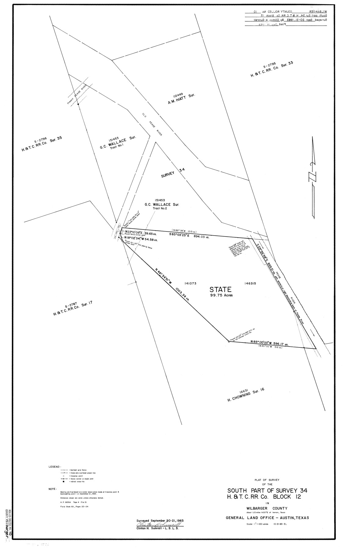
Wilbarger County Rolled Sketch 10
Plat of survey of the south part of survey 34, H. & T. C. R.R. Co. Block 12 in Wilbarger County
-
Map/Doc
8259
-
Collection
General Map Collection
-
Object Dates
1983/10/21 (Creation Date)
1983/12/19 (File Date)
1983/9/21 (Survey Date)
-
People and Organizations
Clinton H. Sumrall (Surveyor/Engineer)
-
Counties
Wilbarger
-
Subjects
Surveying Rolled Sketch
-
Height x Width
37.6 x 23.8 inches
95.5 x 60.5 cm
-
Medium
mylar, print
-
Scale
1" = 100 varas
Part of: General Map Collection
Mills County Boundary File 5b

Print $8.00
- Digital $50.00
Mills County Boundary File 5b
Size 14.2 x 8.7 inches
Map/Doc 57307
Travis County Sketch File 22

Print $6.00
- Digital $50.00
Travis County Sketch File 22
1875
Size 8.5 x 8.5 inches
Map/Doc 38327
Shackelford County Sketch File 8

Print $44.00
- Digital $50.00
Shackelford County Sketch File 8
1936
Size 11.5 x 8.8 inches
Map/Doc 59290
Crockett County Working Sketch 38

Print $20.00
- Digital $50.00
Crockett County Working Sketch 38
1928
Size 28.7 x 16.6 inches
Map/Doc 68371
Flight Mission No. CRC-2R, Frame 178, Chambers County

Print $20.00
- Digital $50.00
Flight Mission No. CRC-2R, Frame 178, Chambers County
1956
Size 18.6 x 22.4 inches
Map/Doc 84756
Wilbarger County Working Sketch 14

Print $20.00
- Digital $50.00
Wilbarger County Working Sketch 14
1955
Size 24.8 x 21.7 inches
Map/Doc 72552
Flight Mission No. CRC-3R, Frame 56, Chambers County

Print $20.00
- Digital $50.00
Flight Mission No. CRC-3R, Frame 56, Chambers County
1956
Size 18.6 x 22.3 inches
Map/Doc 84828
Camp County Working Sketch 3

Print $20.00
- Digital $50.00
Camp County Working Sketch 3
1982
Size 32.1 x 24.4 inches
Map/Doc 67879
Webb County Boundary File 4

Print $8.00
- Digital $50.00
Webb County Boundary File 4
Size 11.2 x 8.8 inches
Map/Doc 59761
Atascosa County Rolled Sketch 18

Print $20.00
- Digital $50.00
Atascosa County Rolled Sketch 18
1955
Size 17.6 x 23.9 inches
Map/Doc 5098
A Pocket Guide to Austin, Texas - Area Map and Downtown Map

A Pocket Guide to Austin, Texas - Area Map and Downtown Map
Size 17.0 x 20.1 inches
Map/Doc 94385
Located Line of the Panhandle & Gulf Ry. through State Lands, Public School and University, in Upton County Texas, Right of Way 200 feet wide

Print $40.00
- Digital $50.00
Located Line of the Panhandle & Gulf Ry. through State Lands, Public School and University, in Upton County Texas, Right of Way 200 feet wide
Size 13.3 x 102.6 inches
Map/Doc 64052
You may also like
Webb County Sketch File 50-1

Print $8.00
- Digital $50.00
Webb County Sketch File 50-1
1943
Size 14.5 x 8.9 inches
Map/Doc 39833
Crockett County Rolled Sketch 90

Print $20.00
- Digital $50.00
Crockett County Rolled Sketch 90
1975
Size 25.4 x 37.3 inches
Map/Doc 5631
Real County Working Sketch 14

Print $20.00
- Digital $50.00
Real County Working Sketch 14
1933
Size 30.2 x 30.5 inches
Map/Doc 71906
General Highway Map, San Augustine County, Texas

Print $20.00
General Highway Map, San Augustine County, Texas
1961
Size 24.6 x 18.1 inches
Map/Doc 79645
Flight Mission No. CUG-3P, Frame 138, Kleberg County

Print $20.00
- Digital $50.00
Flight Mission No. CUG-3P, Frame 138, Kleberg County
1956
Size 18.6 x 22.4 inches
Map/Doc 86273
Carta Etnografica

Print $20.00
- Digital $50.00
Carta Etnografica
1897
Size 26.2 x 34.1 inches
Map/Doc 96798
[Gulf, Colorado & Santa Fe]
![64574, [Gulf, Colorado & Santa Fe], General Map Collection](https://historictexasmaps.com/wmedia_w700/maps/64574.tif.jpg)
Print $40.00
- Digital $50.00
[Gulf, Colorado & Santa Fe]
Size 32.8 x 126.0 inches
Map/Doc 64574
San Patricio County Rolled Sketch 7B

Print $20.00
- Digital $50.00
San Patricio County Rolled Sketch 7B
1870
Size 42.3 x 29.1 inches
Map/Doc 7573
Chambers County Sketch File 8

Print $4.00
- Digital $50.00
Chambers County Sketch File 8
Size 8.0 x 10.7 inches
Map/Doc 17544
Chambers County Rolled Sketch 17

Print $20.00
- Digital $50.00
Chambers County Rolled Sketch 17
1936
Size 38.0 x 32.8 inches
Map/Doc 5425
Hartley County Boundary File 5

Print $6.00
- Digital $50.00
Hartley County Boundary File 5
Size 12.7 x 8.2 inches
Map/Doc 54515
Bastrop County Sketch File 5

Print $4.00
- Digital $50.00
Bastrop County Sketch File 5
Size 8.1 x 10.2 inches
Map/Doc 14048