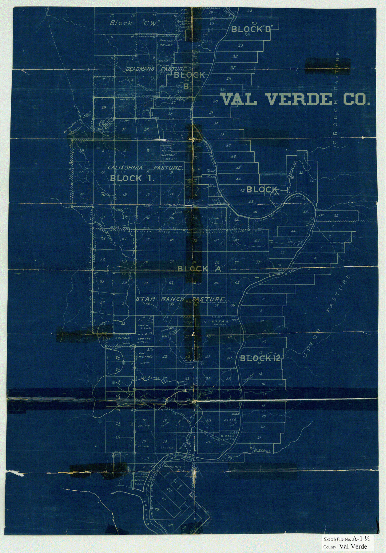
Val Verde County Sketch File A1 1/2
[Sketch of surveys along Devil's River northwest from Del Rio]
-
Map/Doc
12539
-
Collection
General Map Collection
-
Counties
Val Verde
-
Subjects
Surveying Sketch File
-
Height x Width
24.8 x 17.3 inches
63.0 x 43.9 cm
-
Medium
blueprint/diazo
-
Features
Deadman's Creek
Road from Ft. Stockton
Almond's Ranch
Old California Well
Satan's Creek
Hall's Ranch
Evans Creek
Baranco Blanco Creek
9 Mile Waterhole
California Creek
San Pedro Creek
Devil's River
Rio Grande
Part of: General Map Collection
Presidio County Sketch File R

Print $18.00
- Digital $50.00
Presidio County Sketch File R
Size 10.3 x 8.4 inches
Map/Doc 34590
Montgomery County Sketch File 29

Print $8.00
- Digital $50.00
Montgomery County Sketch File 29
1932
Size 11.2 x 8.6 inches
Map/Doc 31884
Brewster County Sketch File NS-3

Print $40.00
- Digital $50.00
Brewster County Sketch File NS-3
1913
Size 30.9 x 15.6 inches
Map/Doc 10986
Gray County Sketch File 3

Print $6.00
- Digital $50.00
Gray County Sketch File 3
1885
Size 12.9 x 8.3 inches
Map/Doc 24415
Controlled Mosaic by Jack Amman Photogrammetric Engineers, Inc - Sheet 54

Print $20.00
- Digital $50.00
Controlled Mosaic by Jack Amman Photogrammetric Engineers, Inc - Sheet 54
1954
Size 20.0 x 24.0 inches
Map/Doc 83513
Brown County Sketch File 2

Print $4.00
- Digital $50.00
Brown County Sketch File 2
Size 11.8 x 8.1 inches
Map/Doc 16582
Part of the boundary between the United States and Texas: from Sabine River northward to the 36th mile mound (A.2)

Print $2.00
- Digital $50.00
Part of the boundary between the United States and Texas: from Sabine River northward to the 36th mile mound (A.2)
1842
Size 12.5 x 7.3 inches
Map/Doc 65387
Bandera County Rolled Sketch 3

Print $20.00
- Digital $50.00
Bandera County Rolled Sketch 3
1947
Size 29.3 x 35.8 inches
Map/Doc 5115
Flight Mission No. BRA-16M, Frame 121, Jefferson County

Print $20.00
- Digital $50.00
Flight Mission No. BRA-16M, Frame 121, Jefferson County
1953
Size 18.4 x 22.4 inches
Map/Doc 85731
Map of Galveston, Turtle & East Bays & portions of the Gulf of Mexico in Chambers & Galveston Counties, Texas showing subdivision for mineral development

Print $40.00
- Digital $50.00
Map of Galveston, Turtle & East Bays & portions of the Gulf of Mexico in Chambers & Galveston Counties, Texas showing subdivision for mineral development
1945
Size 46.3 x 52.8 inches
Map/Doc 3068
Gregg County Working Sketch 19

Print $20.00
- Digital $50.00
Gregg County Working Sketch 19
1957
Size 31.7 x 37.3 inches
Map/Doc 63286
Kenedy County Rolled Sketch 10

Print $20.00
- Digital $50.00
Kenedy County Rolled Sketch 10
1915
Size 21.7 x 35.7 inches
Map/Doc 6470
You may also like
Concho County Sketch File 42

Print $8.00
- Digital $50.00
Concho County Sketch File 42
1948
Size 14.4 x 8.9 inches
Map/Doc 19200
Layout of the porciones as described in the Visita General of Reynosa, 1767

Layout of the porciones as described in the Visita General of Reynosa, 1767
2009
Size 11.0 x 8.5 inches
Map/Doc 94045
Sutton County Working Sketch 63

Print $20.00
- Digital $50.00
Sutton County Working Sketch 63
1961
Size 26.0 x 29.9 inches
Map/Doc 62406
Flight Mission No. CGI-3N, Frame 145, Cameron County

Print $20.00
- Digital $50.00
Flight Mission No. CGI-3N, Frame 145, Cameron County
1954
Size 18.6 x 22.3 inches
Map/Doc 84618
Fort Bend County Rolled Sketch 16A

Print $60.00
- Digital $50.00
Fort Bend County Rolled Sketch 16A
1890
Size 10.6 x 16.6 inches
Map/Doc 44755
The Land Offices. No. 11, Victoria, December 22, 1836

Print $20.00
The Land Offices. No. 11, Victoria, December 22, 1836
2020
Size 21.8 x 21.7 inches
Map/Doc 96424
Stonewall County Rolled Sketch 36A

Print $20.00
- Digital $50.00
Stonewall County Rolled Sketch 36A
Size 17.6 x 22.4 inches
Map/Doc 76403
Kent County Working Sketch 8

Print $20.00
- Digital $50.00
Kent County Working Sketch 8
1952
Size 27.2 x 37.1 inches
Map/Doc 70015
Kinney County Sketch File 24

Print $6.00
- Digital $50.00
Kinney County Sketch File 24
1928
Size 14.2 x 8.8 inches
Map/Doc 29164
[Val Verde County]
![63097, [Val Verde County], General Map Collection](https://historictexasmaps.com/wmedia_w700/maps/63097.tif.jpg)
Print $20.00
- Digital $50.00
[Val Verde County]
1898
Size 41.1 x 37.1 inches
Map/Doc 63097
Roberts County Working Sketch 18

Print $20.00
- Digital $50.00
Roberts County Working Sketch 18
1975
Size 35.6 x 39.7 inches
Map/Doc 63544
Terrell County Working Sketch 41

Print $20.00
- Digital $50.00
Terrell County Working Sketch 41
1957
Size 29.1 x 38.2 inches
Map/Doc 62134