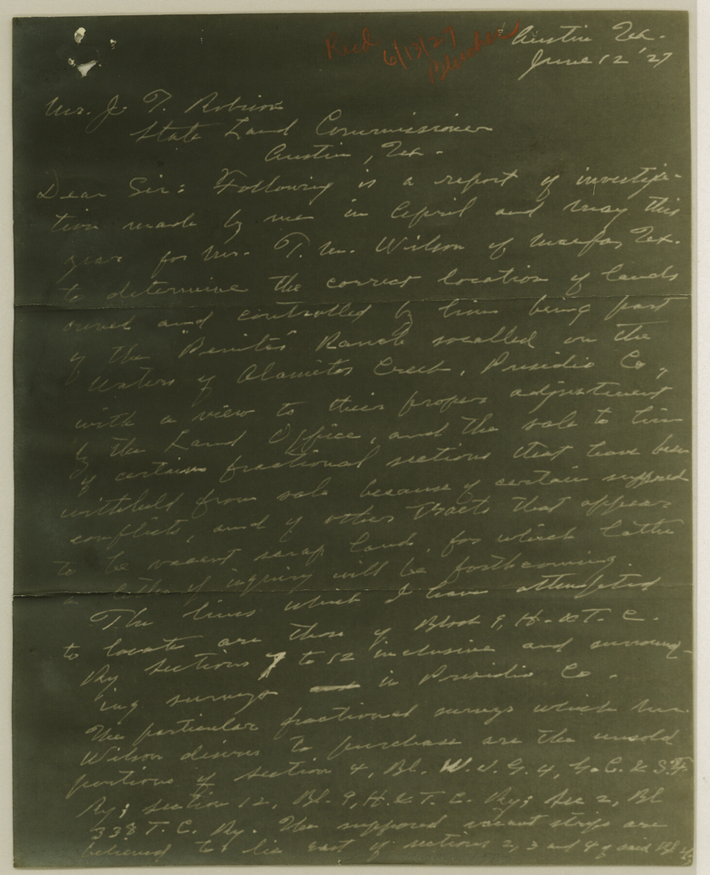
Presidio County Sketch File R
[Report of surveys around the Penitas ranch south of Marfa]
-
Map/Doc
34590
-
Collection
General Map Collection
-
Object Dates
6/13/1927 (File Date)
6/12/1927 (Correspondence Date)
-
People and Organizations
W.L. Rider (Surveyor/Engineer)
D.L. Reavis (Surveyor/Engineer)
Joseph Wilkins Tays (Surveyor/Engineer)
-
Counties
Presidio
-
Subjects
Surveying Sketch File
-
Height x Width
10.3 x 8.4 inches
26.2 x 21.3 cm
-
Medium
photostat
-
Comments
See Presidio County Sketch File R1 (34599) for typed version of report.
-
Features
Benita's Ranch
Alamitos Creek
Related maps
Presidio County Sketch File R1

Print $12.00
- Digital $50.00
Presidio County Sketch File R1
1927
Size 11.3 x 8.7 inches
Map/Doc 34599
Part of: General Map Collection
Flight Mission No. DIX-8P, Frame 84, Aransas County

Print $20.00
- Digital $50.00
Flight Mission No. DIX-8P, Frame 84, Aransas County
1956
Size 18.6 x 22.3 inches
Map/Doc 83909
Menard County Working Sketch 30

Print $20.00
- Digital $50.00
Menard County Working Sketch 30
1974
Size 47.9 x 38.8 inches
Map/Doc 70977
Maps of Gulf Intracoastal Waterway, Texas - Sabine River to the Rio Grande and connecting waterways including ship channels

Print $20.00
- Digital $50.00
Maps of Gulf Intracoastal Waterway, Texas - Sabine River to the Rio Grande and connecting waterways including ship channels
1966
Size 14.5 x 22.3 inches
Map/Doc 61933
Map of the Lands Surveyed by the Memphis, El Paso & Pacific R.R. Company

Print $20.00
- Digital $50.00
Map of the Lands Surveyed by the Memphis, El Paso & Pacific R.R. Company
1860
Size 20.1 x 20.8 inches
Map/Doc 4848
Young County Sketch File 13

Print $4.00
- Digital $50.00
Young County Sketch File 13
1891
Size 8.3 x 10.0 inches
Map/Doc 40878
La Salle County Rolled Sketch 4

Print $20.00
- Digital $50.00
La Salle County Rolled Sketch 4
1937
Size 20.9 x 27.5 inches
Map/Doc 6569
[Sketch for Mineral Application 17237 / Mineral File 11855 - Neches River, Joe A. Sanders]
![2819, [Sketch for Mineral Application 17237 / Mineral File 11855 - Neches River, Joe A. Sanders], General Map Collection](https://historictexasmaps.com/wmedia_w700/maps/2819.tif.jpg)
Print $2.00
- Digital $50.00
[Sketch for Mineral Application 17237 / Mineral File 11855 - Neches River, Joe A. Sanders]
1927
Size 12.8 x 8.2 inches
Map/Doc 2819
Limestone County Sketch File 10b

Print $22.00
- Digital $50.00
Limestone County Sketch File 10b
1875
Size 15.0 x 14.1 inches
Map/Doc 30175
Randall County Sketch File 10

Print $4.00
- Digital $50.00
Randall County Sketch File 10
1941
Size 11.4 x 8.8 inches
Map/Doc 34972
Burleson County

Print $20.00
- Digital $50.00
Burleson County
1920
Size 40.6 x 45.7 inches
Map/Doc 4896
Mason County Boundary File 5

Print $20.00
- Digital $50.00
Mason County Boundary File 5
Size 9.7 x 7.0 inches
Map/Doc 56862
[Galveston, Harrisburg & San Antonio Railway]
![64406, [Galveston, Harrisburg & San Antonio Railway], General Map Collection](https://historictexasmaps.com/wmedia_w700/maps/64406.tif.jpg)
Print $20.00
- Digital $50.00
[Galveston, Harrisburg & San Antonio Railway]
1892
Size 13.5 x 33.6 inches
Map/Doc 64406
You may also like
Flight Mission No. CLL-1N, Frame 182, Willacy County

Print $20.00
- Digital $50.00
Flight Mission No. CLL-1N, Frame 182, Willacy County
1954
Size 18.4 x 22.0 inches
Map/Doc 87052
Presidio County Rolled Sketch 35

Print $20.00
- Digital $50.00
Presidio County Rolled Sketch 35
Size 44.7 x 32.1 inches
Map/Doc 9774
Palo Pinto County Working Sketch 27

Print $20.00
- Digital $50.00
Palo Pinto County Working Sketch 27
2006
Map/Doc 83609
Bandera County Sketch File 35

Print $2.00
- Digital $50.00
Bandera County Sketch File 35
Size 11.2 x 8.7 inches
Map/Doc 14033
Dimmit County Working Sketch 50

Print $20.00
- Digital $50.00
Dimmit County Working Sketch 50
1981
Size 34.0 x 39.0 inches
Map/Doc 68711
Dimmit County Sketch File 2

Print $6.00
- Digital $50.00
Dimmit County Sketch File 2
Size 8.6 x 7.9 inches
Map/Doc 21055
Map of Townsite of Swearingen, Cottle County, Texas

Print $20.00
- Digital $50.00
Map of Townsite of Swearingen, Cottle County, Texas
1919
Size 28.1 x 17.1 inches
Map/Doc 4463
Flight Mission No. CUG-2P, Frame 25, Kleberg County

Print $20.00
- Digital $50.00
Flight Mission No. CUG-2P, Frame 25, Kleberg County
1956
Size 18.5 x 22.2 inches
Map/Doc 86189
Burleson County Working Sketch 5

Print $20.00
- Digital $50.00
Burleson County Working Sketch 5
1980
Size 34.8 x 27.6 inches
Map/Doc 67724
Fisher County Sketch File 18

Print $12.00
- Digital $50.00
Fisher County Sketch File 18
1901
Size 8.2 x 5.5 inches
Map/Doc 22589
Houston County Sketch File 27

Print $20.00
- Digital $50.00
Houston County Sketch File 27
Size 18.8 x 21.6 inches
Map/Doc 11788
Webb County Rolled Sketch 78A

Print $20.00
- Digital $50.00
Webb County Rolled Sketch 78A
Size 28.4 x 23.0 inches
Map/Doc 90053