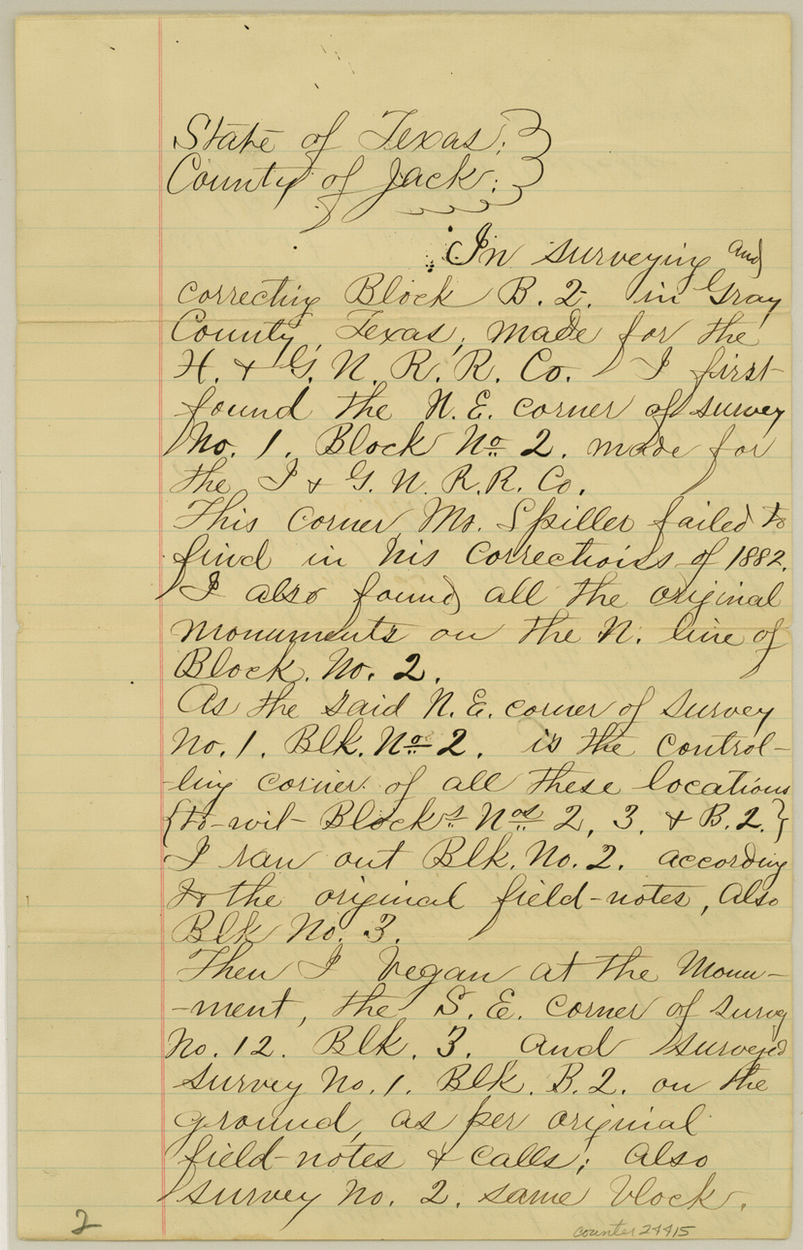
Gray County Sketch File 3
[Statement in regard to corrected field notes in Block B2]
-
Map/Doc
24415
-
Collection
General Map Collection
-
Object Dates
1885/4/10 (Creation Date)
1885/4/28 (File Date)
-
People and Organizations
F.M. Crutcher (Surveyor/Engineer)
-
Counties
Gray
-
Subjects
Surveying Sketch File
-
Height x Width
12.9 x 8.3 inches
32.8 x 21.1 cm
-
Medium
paper, manuscript
Part of: General Map Collection
Harris County Sketch File 21

Print $4.00
- Digital $50.00
Harris County Sketch File 21
1862
Size 13.1 x 8.2 inches
Map/Doc 25373
Taylor County Rolled Sketch 27A

Print $20.00
- Digital $50.00
Taylor County Rolled Sketch 27A
Size 30.5 x 21.4 inches
Map/Doc 7919
Jackson County Rolled Sketch 3C

Print $59.00
- Digital $50.00
Jackson County Rolled Sketch 3C
1913
Size 23.7 x 21.8 inches
Map/Doc 6339
Coast of Texas and its defences

Print $20.00
- Digital $50.00
Coast of Texas and its defences
Size 27.6 x 18.2 inches
Map/Doc 72685
Johnson County Working Sketch 27

Print $20.00
- Digital $50.00
Johnson County Working Sketch 27
2006
Size 37.3 x 44.0 inches
Map/Doc 83651
Concho County

Print $40.00
- Digital $50.00
Concho County
1947
Size 48.1 x 37.3 inches
Map/Doc 95464
Polk County Working Sketch 3

Print $40.00
- Digital $50.00
Polk County Working Sketch 3
1911
Size 25.4 x 56.0 inches
Map/Doc 71618
Culberson County Sketch File WJ1

Print $6.00
- Digital $50.00
Culberson County Sketch File WJ1
1927
Size 11.2 x 8.9 inches
Map/Doc 20154
El Paso County Sketch File 19

Print $30.00
- Digital $50.00
El Paso County Sketch File 19
1905
Size 13.3 x 8.7 inches
Map/Doc 22009
[Northern boundary line of McMullen's claim]
![313, [Northern boundary line of McMullen's claim], General Map Collection](https://historictexasmaps.com/wmedia_w700/maps/313.tif.jpg)
Print $2.00
- Digital $50.00
[Northern boundary line of McMullen's claim]
1847
Size 13.5 x 8.0 inches
Map/Doc 313
Jones County Sketch File 1

Print $20.00
- Digital $50.00
Jones County Sketch File 1
1857
Size 17.8 x 30.3 inches
Map/Doc 11894
Jefferson County Rolled Sketch 60

Print $20.00
- Digital $50.00
Jefferson County Rolled Sketch 60
1885
Size 31.0 x 35.6 inches
Map/Doc 9315
You may also like
Mason County Sketch File 17a

Print $6.00
- Digital $50.00
Mason County Sketch File 17a
1887
Size 10.3 x 10.9 inches
Map/Doc 30707
Presidio County Sketch File 111

Print $4.00
- Digital $50.00
Presidio County Sketch File 111
1885
Size 14.3 x 9.1 inches
Map/Doc 34824
Map of the Pitchfork Ranch

Print $20.00
- Digital $50.00
Map of the Pitchfork Ranch
1915
Size 39.7 x 35.6 inches
Map/Doc 75827
[Sketch of Part of B. S. & F. Block 9]
![93090, [Sketch of Part of B. S. & F. Block 9], Twichell Survey Records](https://historictexasmaps.com/wmedia_w700/maps/93090-1.tif.jpg)
Print $2.00
- Digital $50.00
[Sketch of Part of B. S. & F. Block 9]
Size 7.6 x 7.4 inches
Map/Doc 93090
Childress County Rolled Sketch 8

Print $20.00
- Digital $50.00
Childress County Rolled Sketch 8
1889
Size 12.4 x 22.2 inches
Map/Doc 5442
Jeff Davis County Rolled Sketch 11

Print $20.00
- Digital $50.00
Jeff Davis County Rolled Sketch 11
1914
Size 17.9 x 14.4 inches
Map/Doc 6364
Pecos County Working Sketch 57

Print $20.00
- Digital $50.00
Pecos County Working Sketch 57
1949
Size 24.2 x 26.4 inches
Map/Doc 71529
Blocks No. 8, 9 & 10 Houston & Great Northern Rail Road Company Surveys in Pecos County, Texas

Print $20.00
- Digital $50.00
Blocks No. 8, 9 & 10 Houston & Great Northern Rail Road Company Surveys in Pecos County, Texas
1891
Size 24.5 x 38.7 inches
Map/Doc 3955
Galveston County Sketch File 70

Print $26.00
- Digital $50.00
Galveston County Sketch File 70
1983
Size 11.3 x 8.7 inches
Map/Doc 23928
Connected Map of Austin's Colony

Print $20.00
- Digital $50.00
Connected Map of Austin's Colony
1892
Size 47.3 x 43.3 inches
Map/Doc 76075
Bosque County Sketch File 11

Print $4.00
- Digital $50.00
Bosque County Sketch File 11
1863
Size 10.2 x 8.3 inches
Map/Doc 14759
Lynn County Working Sketch 3

Print $20.00
- Digital $50.00
Lynn County Working Sketch 3
1953
Size 30.8 x 30.9 inches
Map/Doc 70673