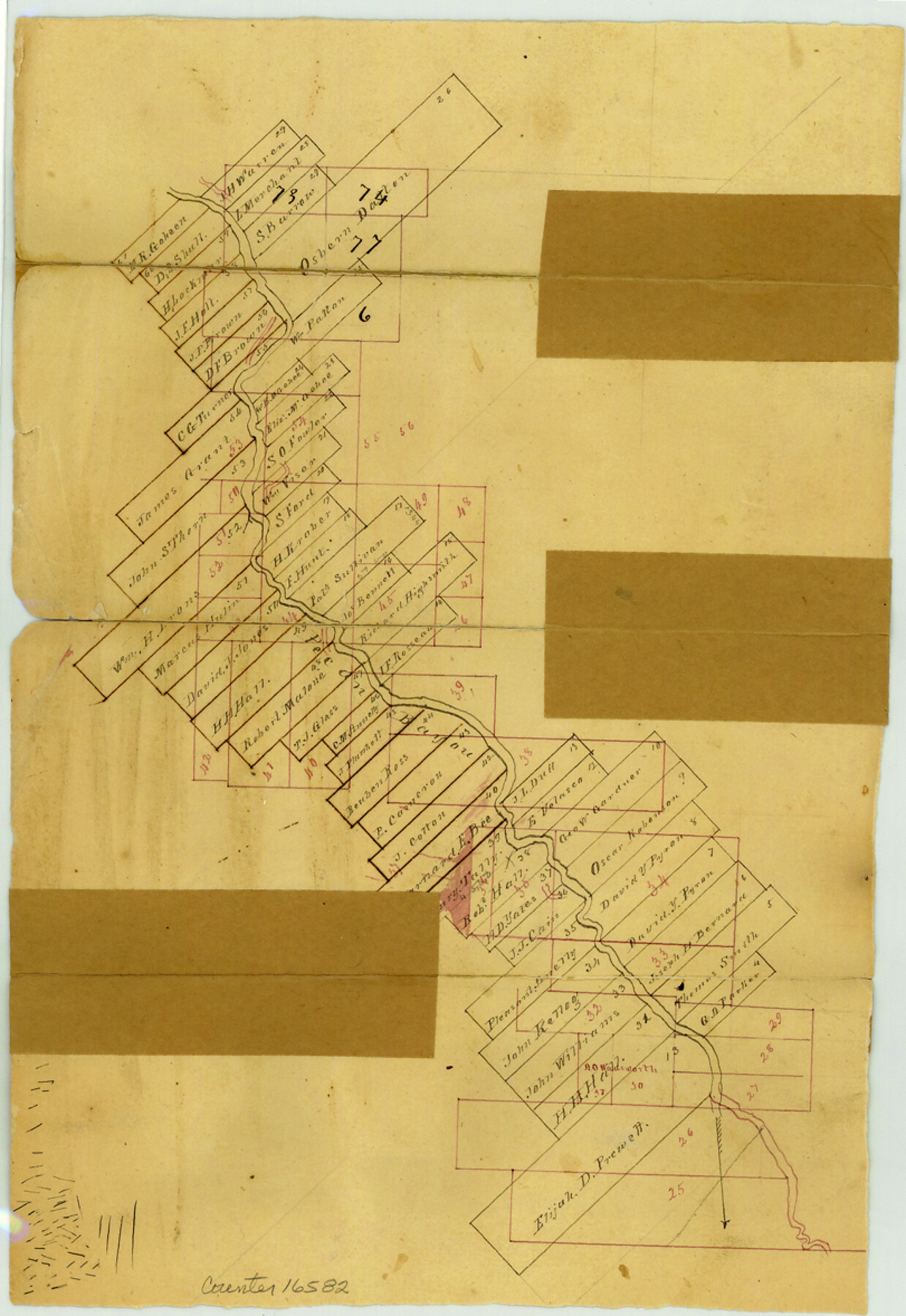
Brown County Sketch File 2
[Office sketch of surveys on both banks of Pecan Bayou north and south of Brownwood]
-
Map/Doc
16582
-
Collection
General Map Collection
-
Counties
Brown
-
Subjects
Surveying Sketch File
-
Height x Width
11.8 x 8.1 inches
30.0 x 20.6 cm
-
Medium
paper, manuscript
-
Features
Pecan Bayou
Part of: General Map Collection
Limestone County Working Sketch 2

Print $20.00
- Digital $50.00
Limestone County Working Sketch 2
Size 17.3 x 15.9 inches
Map/Doc 70552
Gaines County Working Sketch 3

Print $20.00
- Digital $50.00
Gaines County Working Sketch 3
1939
Size 45.6 x 43.8 inches
Map/Doc 69303
Zapata County Sketch File 8

Print $40.00
- Digital $50.00
Zapata County Sketch File 8
1917
Size 59.5 x 26.5 inches
Map/Doc 10438
[Galveston, Harrisburg & San Antonio Railway]
![64405, [Galveston, Harrisburg & San Antonio Railway], General Map Collection](https://historictexasmaps.com/wmedia_w700/maps/64405.tif.jpg)
Print $20.00
- Digital $50.00
[Galveston, Harrisburg & San Antonio Railway]
1892
Size 13.5 x 33.6 inches
Map/Doc 64405
Flight Mission No. DAG-14K, Frame 43, Matagorda County

Print $20.00
- Digital $50.00
Flight Mission No. DAG-14K, Frame 43, Matagorda County
1952
Size 18.4 x 22.4 inches
Map/Doc 86301
Gaines County Working Sketch 15

Print $40.00
- Digital $50.00
Gaines County Working Sketch 15
1958
Size 66.3 x 34.0 inches
Map/Doc 69315
Andrews County

Print $20.00
- Digital $50.00
Andrews County
1895
Size 24.9 x 26.4 inches
Map/Doc 3231
Chambers County Sketch File 23

Print $2.00
- Digital $50.00
Chambers County Sketch File 23
1878
Size 10.0 x 7.9 inches
Map/Doc 17597
Gulf Intracoastal Waterway, Tex. - Aransas Bay to Corpus Christi Bay - Modified Route of Main Channel/Dredging

Print $20.00
- Digital $50.00
Gulf Intracoastal Waterway, Tex. - Aransas Bay to Corpus Christi Bay - Modified Route of Main Channel/Dredging
1958
Size 31.3 x 42.6 inches
Map/Doc 61894
Angelina County Sketch File 14

Print $2.00
- Digital $50.00
Angelina County Sketch File 14
Size 7.6 x 6.9 inches
Map/Doc 12959
Dickens County Working Sketch 1

Print $20.00
- Digital $50.00
Dickens County Working Sketch 1
Size 15.5 x 15.5 inches
Map/Doc 68648
Map of west half of Sabine Lake, Jefferson Co., showing subdivision for mineral development

Print $20.00
- Digital $50.00
Map of west half of Sabine Lake, Jefferson Co., showing subdivision for mineral development
1956
Size 37.9 x 28.4 inches
Map/Doc 2897
You may also like
Menard County Boundary File 7

Print $6.00
- Digital $50.00
Menard County Boundary File 7
Size 10.5 x 8.1 inches
Map/Doc 57089
El Paso County Sketch File 42

Print $16.00
- Digital $50.00
El Paso County Sketch File 42
1996
Size 14.3 x 8.9 inches
Map/Doc 22241
Kinney County Sketch File D

Print $20.00
- Digital $50.00
Kinney County Sketch File D
1885
Size 25.1 x 35.6 inches
Map/Doc 11953
Fractional Township No. 6 South Range No. 7 West of the Indian Meridian, Indian Territory

Print $20.00
- Digital $50.00
Fractional Township No. 6 South Range No. 7 West of the Indian Meridian, Indian Territory
1898
Size 19.4 x 24.3 inches
Map/Doc 75157
Kendall County Working Sketch 22

Print $20.00
- Digital $50.00
Kendall County Working Sketch 22
1971
Size 41.6 x 34.7 inches
Map/Doc 66694
Map of Crockett Co.

Print $20.00
- Digital $50.00
Map of Crockett Co.
1901
Size 31.7 x 42.4 inches
Map/Doc 1475
San Patricio County Rolled Sketch 20

Print $20.00
- Digital $50.00
San Patricio County Rolled Sketch 20
1953
Size 37.6 x 31.9 inches
Map/Doc 7578
Stephens County Sketch File 10c

Print $6.00
- Digital $50.00
Stephens County Sketch File 10c
Size 7.8 x 11.5 inches
Map/Doc 37052
Map of Shamrock Cemetery Located in Southwest 10 acres of Southeast 1/4 Section 43, Block 17

Print $20.00
- Digital $50.00
Map of Shamrock Cemetery Located in Southwest 10 acres of Southeast 1/4 Section 43, Block 17
Size 22.8 x 24.0 inches
Map/Doc 92134
McCulloch County Sketch File 9

Print $6.00
- Digital $50.00
McCulloch County Sketch File 9
1883
Size 7.3 x 8.7 inches
Map/Doc 31184
Presidio County

Print $40.00
- Digital $50.00
Presidio County
1875
Size 98.1 x 58.7 inches
Map/Doc 16792
Chambers County Working Sketch 5

Print $20.00
- Digital $50.00
Chambers County Working Sketch 5
1938
Size 20.9 x 31.6 inches
Map/Doc 67988