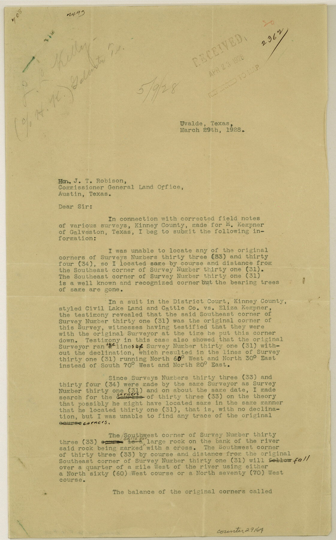
Kinney County Sketch File 24
[Letter in regard to location of the Kempner Lands]
-
Map/Doc
29164
-
Collection
General Map Collection
-
Object Dates
3/29/1928 (Creation Date)
4/23/1928 (File Date)
-
People and Organizations
E.R. Benson (Surveyor/Engineer)
-
Counties
Kinney
-
Subjects
Surveying Sketch File
-
Height x Width
14.2 x 8.8 inches
36.1 x 22.4 cm
-
Medium
paper, print
Part of: General Map Collection
Mason County Rolled Sketch 4

Print $20.00
- Digital $50.00
Mason County Rolled Sketch 4
1983
Size 23.3 x 26.9 inches
Map/Doc 6677
San Augustine County Working Sketch 5

Print $20.00
- Digital $50.00
San Augustine County Working Sketch 5
1935
Size 39.0 x 37.4 inches
Map/Doc 63692
Map of Wise County Texas

Print $20.00
- Digital $50.00
Map of Wise County Texas
1912
Size 31.3 x 28.8 inches
Map/Doc 4644
Galveston County NRC Article 33.136 Sketch 97

Print $414.00
Galveston County NRC Article 33.136 Sketch 97
2024
Map/Doc 97407
Harris County NRC Article 33.136 Sketch 14

Print $50.00
- Digital $50.00
Harris County NRC Article 33.136 Sketch 14
Size 24.0 x 36.0 inches
Map/Doc 94816
Van Zandt County Sketch File 43

Print $4.00
- Digital $50.00
Van Zandt County Sketch File 43
1874
Size 12.7 x 8.1 inches
Map/Doc 39497
Liberty County Rolled Sketch C

Print $20.00
- Digital $50.00
Liberty County Rolled Sketch C
1941
Size 39.5 x 35.4 inches
Map/Doc 9571
Real County Working Sketch 81

Print $20.00
- Digital $50.00
Real County Working Sketch 81
1984
Size 19.9 x 17.1 inches
Map/Doc 71973
Uvalde County Working Sketch 57

Print $20.00
- Digital $50.00
Uvalde County Working Sketch 57
1985
Size 38.4 x 43.0 inches
Map/Doc 72127
General Homes Free Houston Area Map

General Homes Free Houston Area Map
Size 27.1 x 42.5 inches
Map/Doc 94393
Harris County Rolled Sketch R

Print $40.00
- Digital $50.00
Harris County Rolled Sketch R
1915
Size 20.3 x 93.8 inches
Map/Doc 9114
Armstrong County Working Sketch 3

Print $20.00
- Digital $50.00
Armstrong County Working Sketch 3
1904
Size 46.1 x 40.8 inches
Map/Doc 67234
You may also like
Erath County Working Sketch 14

Print $20.00
- Digital $50.00
Erath County Working Sketch 14
1959
Size 24.7 x 21.9 inches
Map/Doc 69095
Duval County Sketch File 60

Print $6.00
- Digital $50.00
Duval County Sketch File 60
1940
Size 11.3 x 9.0 inches
Map/Doc 21428
[Surveys in the Bexar District along the Guadalupe River]
![124, [Surveys in the Bexar District along the Guadalupe River], General Map Collection](https://historictexasmaps.com/wmedia_w700/maps/124.tif.jpg)
Print $3.00
- Digital $50.00
[Surveys in the Bexar District along the Guadalupe River]
1841
Size 17.2 x 10.8 inches
Map/Doc 124
Carte du Canada et de la Louisiane qui forment la Nouvelle France et des colonies angloises ou sont representez les pays contestez

Print $20.00
- Digital $50.00
Carte du Canada et de la Louisiane qui forment la Nouvelle France et des colonies angloises ou sont representez les pays contestez
1756
Size 21.5 x 29.6 inches
Map/Doc 97415
Lubbock County

Print $20.00
- Digital $50.00
Lubbock County
1879
Size 21.3 x 19.1 inches
Map/Doc 4583
Flight Mission No. BRE-1P, Frame 10, Nueces County

Print $20.00
- Digital $50.00
Flight Mission No. BRE-1P, Frame 10, Nueces County
1956
Size 18.4 x 22.5 inches
Map/Doc 86618
Map of Kendall County

Print $20.00
- Digital $50.00
Map of Kendall County
1899
Size 36.7 x 34.4 inches
Map/Doc 4999
The Republic County of San Augustine. Boundaries Defined, December 14, 1837

Print $20.00
The Republic County of San Augustine. Boundaries Defined, December 14, 1837
2020
Size 18.8 x 21.7 inches
Map/Doc 96271
Hale County Sketch File 19

Print $4.00
- Digital $50.00
Hale County Sketch File 19
Size 8.4 x 8.8 inches
Map/Doc 24751
Travis County Rolled Sketch 38

Print $20.00
- Digital $50.00
Travis County Rolled Sketch 38
Size 31.9 x 30.3 inches
Map/Doc 8038
Burnet County Boundary File 8

Print $88.00
- Digital $50.00
Burnet County Boundary File 8
Size 8.7 x 32.2 inches
Map/Doc 50908
[H. & T. C. RR. Company, Block 47]
![91162, [H. & T. C. RR. Company, Block 47], Twichell Survey Records](https://historictexasmaps.com/wmedia_w700/maps/91162-1.tif.jpg)
Print $20.00
- Digital $50.00
[H. & T. C. RR. Company, Block 47]
1921
Size 13.1 x 20.6 inches
Map/Doc 91162