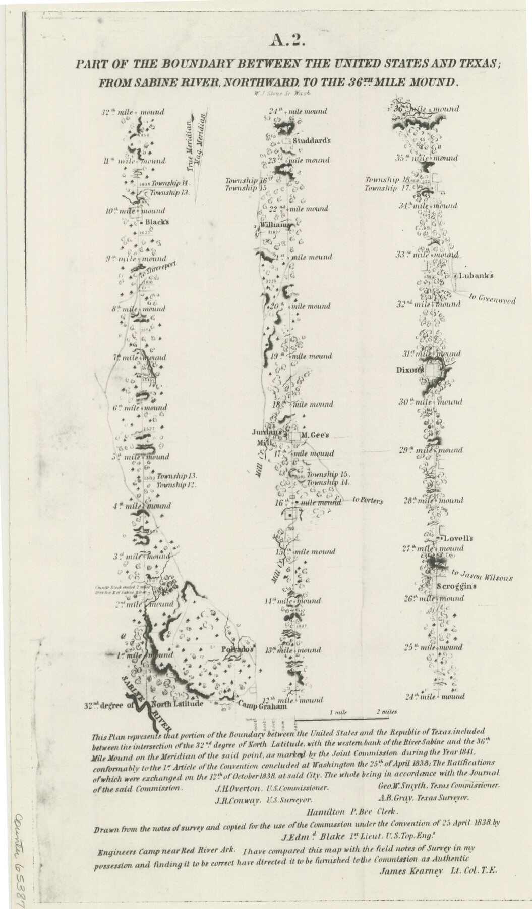
Part of the boundary between the United States and Texas: from Sabine River northward to the 36th mile mound (A.2)
K-7-65
-
Map/Doc
65387
-
Collection
General Map Collection
-
Object Dates
1842 (Creation Date)
-
People and Organizations
Joint Boundary Commission (Author)
J.E. Blake (Draftsman)
J.R. Conway (Surveyor/Engineer)
A.B. Gray (Surveyor/Engineer)
-
Subjects
Texas Boundaries
-
Height x Width
12.5 x 7.3 inches
31.8 x 18.5 cm
-
Comments
Shows the boundary between the United States and the Republic of Texas between the intersection of the 32nd degree of North Latitude, with the western bank of the River Sabine and the 36th Mile Mound on the Meridian of the said point, as marked by the Joi
Part of: General Map Collection
Travis County Rolled Sketch 55

Print $40.00
- Digital $50.00
Travis County Rolled Sketch 55
Size 43.1 x 50.5 inches
Map/Doc 10020
Collingsworth County

Print $20.00
- Digital $50.00
Collingsworth County
1892
Size 26.5 x 20.8 inches
Map/Doc 66759
Terrell County Rolled Sketch 51A

Print $20.00
- Digital $50.00
Terrell County Rolled Sketch 51A
1957
Size 29.1 x 20.6 inches
Map/Doc 7968
Map of Caldwell County

Print $20.00
- Digital $50.00
Map of Caldwell County
1871
Size 16.9 x 19.9 inches
Map/Doc 4591
Brewster County Rolled Sketch 148A

Print $20.00
- Digital $50.00
Brewster County Rolled Sketch 148A
1994
Size 28.0 x 36.3 inches
Map/Doc 5314
Presidio County Rolled Sketch 116

Print $20.00
- Digital $50.00
Presidio County Rolled Sketch 116
1981
Size 30.9 x 25.0 inches
Map/Doc 9795
University Lands Situated in Robertson County

Print $20.00
- Digital $50.00
University Lands Situated in Robertson County
1841
Size 22.8 x 26.2 inches
Map/Doc 281
[Surveys along the Bosque River]
![260, [Surveys along the Bosque River], General Map Collection](https://historictexasmaps.com/wmedia_w700/maps/260.tif.jpg)
Print $2.00
- Digital $50.00
[Surveys along the Bosque River]
1846
Size 9.3 x 7.8 inches
Map/Doc 260
Duval County Sketch File 39

Print $20.00
- Digital $50.00
Duval County Sketch File 39
Size 32.1 x 23.9 inches
Map/Doc 11395
Map of Augustine Cty.

Print $20.00
- Digital $50.00
Map of Augustine Cty.
1839
Size 22.9 x 14.6 inches
Map/Doc 165
The Texas and Pacific Ry. Co., Station Map, Loraine, Texas

Print $20.00
- Digital $50.00
The Texas and Pacific Ry. Co., Station Map, Loraine, Texas
Size 11.6 x 18.6 inches
Map/Doc 64683
Pecos County Sketch File 100

Print $20.00
- Digital $50.00
Pecos County Sketch File 100
1959
Size 16.4 x 29.9 inches
Map/Doc 12186
You may also like
Myrick Farms Lubbock & Hockley Counties

Print $20.00
- Digital $50.00
Myrick Farms Lubbock & Hockley Counties
Size 21.3 x 21.5 inches
Map/Doc 92830
Flight Mission No. CLL-1N, Frame 196, Willacy County

Print $20.00
- Digital $50.00
Flight Mission No. CLL-1N, Frame 196, Willacy County
1954
Size 18.5 x 22.2 inches
Map/Doc 87066
Kent County Working Sketch 25

Print $20.00
- Digital $50.00
Kent County Working Sketch 25
1989
Size 18.8 x 18.5 inches
Map/Doc 69641
Morris County Rolled Sketch 2A

Print $20.00
- Digital $50.00
Morris County Rolled Sketch 2A
Size 24.3 x 19.2 inches
Map/Doc 10284
Ward County Rolled Sketch 18

Print $20.00
- Digital $50.00
Ward County Rolled Sketch 18
1949
Size 31.6 x 34.0 inches
Map/Doc 10109
Dallas County Working Sketch 8

Print $20.00
- Digital $50.00
Dallas County Working Sketch 8
1953
Size 20.6 x 26.4 inches
Map/Doc 68574
Hardeman County Working Sketch 14

Print $20.00
- Digital $50.00
Hardeman County Working Sketch 14
Size 30.8 x 42.2 inches
Map/Doc 63395
Uvalde County Working Sketch 42

Print $20.00
- Digital $50.00
Uvalde County Working Sketch 42
1978
Size 34.5 x 27.9 inches
Map/Doc 72112
Houston County Working Sketch 5

Print $20.00
- Digital $50.00
Houston County Working Sketch 5
Size 24.9 x 28.1 inches
Map/Doc 66235
Val Verde County Working Sketch 9

Print $20.00
- Digital $50.00
Val Verde County Working Sketch 9
1917
Size 19.4 x 30.9 inches
Map/Doc 72144
Port Facilities at Texas City, Tex.

Print $20.00
- Digital $50.00
Port Facilities at Texas City, Tex.
Size 13.9 x 15.9 inches
Map/Doc 97161
Presidio County Working Sketch 30

Print $20.00
- Digital $50.00
Presidio County Working Sketch 30
1946
Size 32.3 x 40.9 inches
Map/Doc 71707