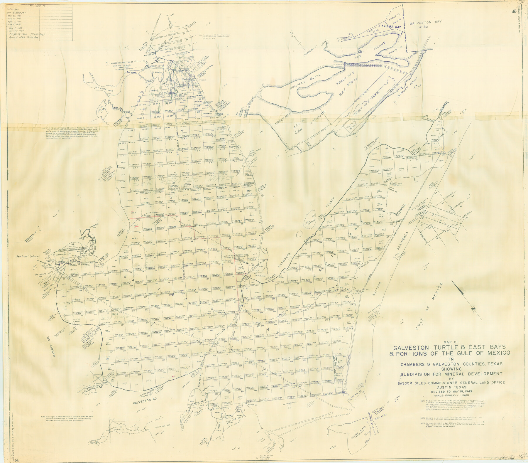
Map of Galveston, Turtle & East Bays & portions of the Gulf of Mexico in Chambers & Galveston Counties, Texas showing subdivision for mineral development
K-3-77
-
Map/Doc
3068
-
Collection
General Map Collection
-
Object Dates
1945 (Creation Date)
-
People and Organizations
General Land Office (Publisher)
Bascom Giles (GLO Commissioner)
-
Counties
Chambers Galveston
-
Subjects
Energy Offshore Submerged Area
-
Height x Width
46.3 x 52.8 inches
117.6 x 134.1 cm
Part of: General Map Collection
Real County Working Sketch 67

Print $20.00
- Digital $50.00
Real County Working Sketch 67
1970
Size 21.2 x 16.4 inches
Map/Doc 71959
Flight Mission No. DQO-7K, Frame 100, Galveston County

Print $20.00
- Digital $50.00
Flight Mission No. DQO-7K, Frame 100, Galveston County
1952
Size 18.6 x 22.7 inches
Map/Doc 85115
Anderson County Sketch File 15

Print $40.00
- Digital $50.00
Anderson County Sketch File 15
1849
Size 13.6 x 15.6 inches
Map/Doc 10800
Abandoned and Canceled Surveys - Volume 1 of 3, Counties A-D

Abandoned and Canceled Surveys - Volume 1 of 3, Counties A-D
Map/Doc 83248
Burnet County Boundary File 12

Print $14.00
- Digital $50.00
Burnet County Boundary File 12
Size 8.2 x 6.0 inches
Map/Doc 50949
Comal County Working Sketch 5

Print $20.00
- Digital $50.00
Comal County Working Sketch 5
1950
Size 19.0 x 21.4 inches
Map/Doc 68171
Neches River, Watershed of the Neches River

Print $6.00
- Digital $50.00
Neches River, Watershed of the Neches River
1925
Size 34.6 x 28.3 inches
Map/Doc 65085
Grayson County Working Sketch 24

Print $20.00
- Digital $50.00
Grayson County Working Sketch 24
1977
Size 34.5 x 42.1 inches
Map/Doc 63263

San Jacinto County Rolled Sketch 5

Print $20.00
- Digital $50.00
San Jacinto County Rolled Sketch 5
Size 13.7 x 18.6 inches
Map/Doc 8386

Coke County Working Sketch 27

Print $20.00
- Digital $50.00
Coke County Working Sketch 27
1962
Size 17.4 x 27.7 inches
Map/Doc 68064
You may also like
Flight Mission No. CLL-3N, Frame 44, Willacy County

Print $20.00
- Digital $50.00
Flight Mission No. CLL-3N, Frame 44, Willacy County
1954
Size 18.4 x 22.0 inches
Map/Doc 87102
Wichita County Working Sketch 17

Print $20.00
- Digital $50.00
Wichita County Working Sketch 17
1940
Size 25.6 x 26.1 inches
Map/Doc 72527
Flight Mission No. BQY-4M, Frame 43, Harris County

Print $20.00
- Digital $50.00
Flight Mission No. BQY-4M, Frame 43, Harris County
1953
Size 18.6 x 22.3 inches
Map/Doc 85258
[Surveys along Eight Mile Creek, Harrison District]
![278, [Surveys along Eight Mile Creek, Harrison District], General Map Collection](https://historictexasmaps.com/wmedia_w700/maps/278.tif.jpg)
Print $3.00
- Digital $50.00
[Surveys along Eight Mile Creek, Harrison District]
Size 12.6 x 9.3 inches
Map/Doc 278
Crockett County Working Sketch 68

Print $40.00
- Digital $50.00
Crockett County Working Sketch 68
1959
Size 23.7 x 55.6 inches
Map/Doc 68401
2008 Official Travel Map Texas

Digital $50.00
2008 Official Travel Map Texas
Size 33.4 x 36.5 inches
Map/Doc 94310
Uvalde County Boundary File 1a

Print $12.00
- Digital $50.00
Uvalde County Boundary File 1a
Size 14.5 x 8.9 inches
Map/Doc 59551
Jefferson County Rolled Sketch 48

Print $20.00
- Digital $50.00
Jefferson County Rolled Sketch 48
Size 15.3 x 24.9 inches
Map/Doc 6405
Wood County Sketch File 15

Print $5.00
- Digital $50.00
Wood County Sketch File 15
1835
Size 11.0 x 16.3 inches
Map/Doc 40694
Liberty County Sketch File 63

Print $138.00
- Digital $50.00
Liberty County Sketch File 63
1983
Size 11.1 x 8.8 inches
Map/Doc 30087
Ward County State of Texas

Print $20.00
- Digital $50.00
Ward County State of Texas
1888
Size 22.6 x 26.0 inches
Map/Doc 4641
Coryell County Working Sketch 27

Print $20.00
- Digital $50.00
Coryell County Working Sketch 27
1988
Size 15.5 x 20.0 inches
Map/Doc 68234