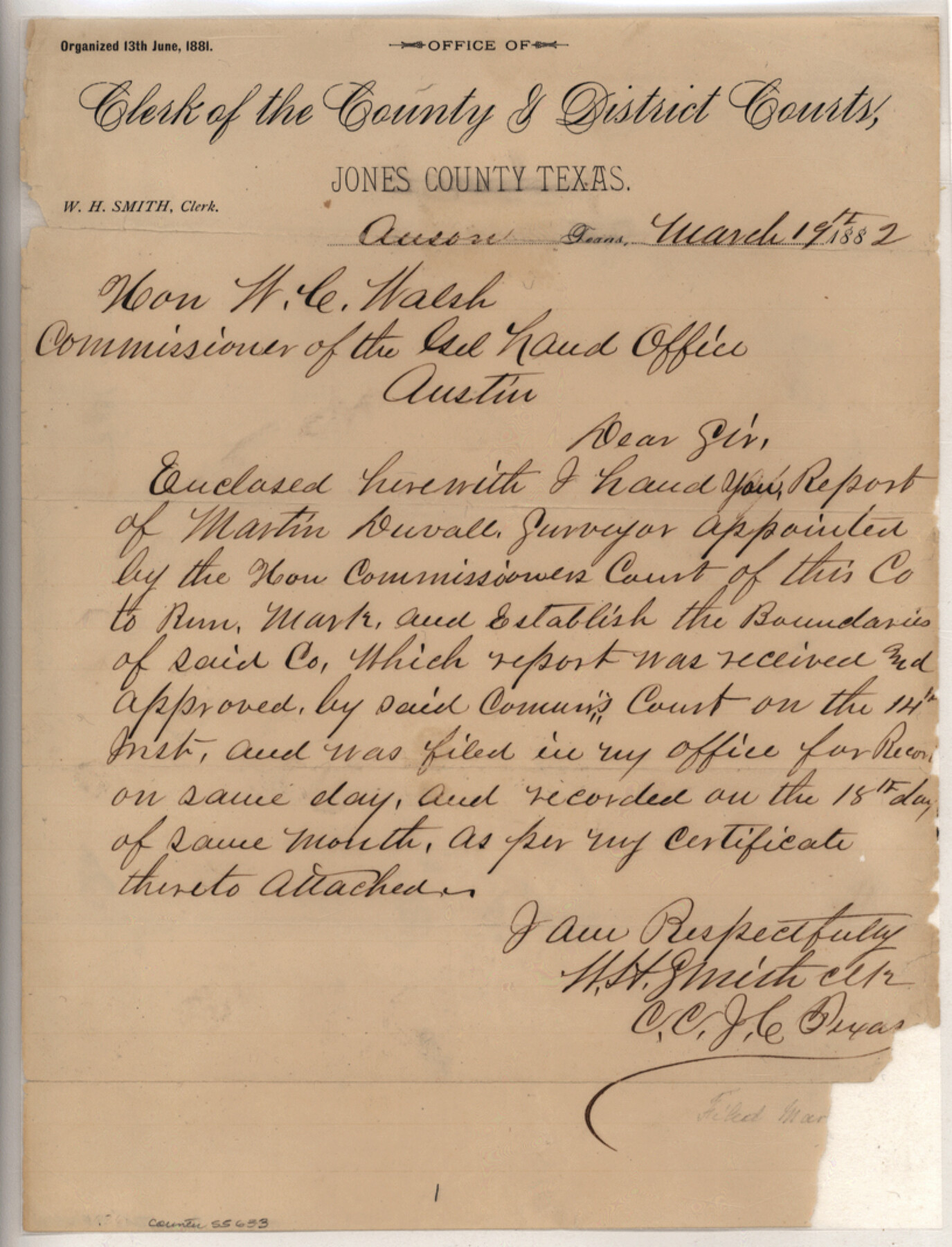
Jones County Boundary File 1
[Fieldnotes of the Boundary lines of Jones County]
-
Map/Doc
55633
-
Collection
General Map Collection
-
Object Dates
1882/3/19 (Creation Date)
1882/3/24 (File Date)
-
People and Organizations
W.H. Smith (Author)
-
Counties
Jones
-
Subjects
County Boundaries
-
Height x Width
10.7 x 8.2 inches
27.2 x 20.8 cm
Part of: General Map Collection
Map of Austin's Li[ttle Colony Above the] San [Antonio Road]
![215, Map of Austin's Li[ttle Colony Above the] San [Antonio Road], General Map Collection](https://historictexasmaps.com/wmedia_w700/maps/215.tif.jpg)
Print $20.00
- Digital $50.00
Map of Austin's Li[ttle Colony Above the] San [Antonio Road]
1831
Size 14.2 x 19.3 inches
Map/Doc 215
Cameron County Boundary File 3

Print $26.00
- Digital $50.00
Cameron County Boundary File 3
Size 14.4 x 8.4 inches
Map/Doc 51097
Maps of Gulf Intracoastal Waterway, Texas - Sabine River to the Rio Grande and connecting waterways including ship channels

Print $20.00
- Digital $50.00
Maps of Gulf Intracoastal Waterway, Texas - Sabine River to the Rio Grande and connecting waterways including ship channels
1966
Size 14.6 x 22.3 inches
Map/Doc 61916
Flight Mission No. CGI-3N, Frame 182, Cameron County

Print $20.00
- Digital $50.00
Flight Mission No. CGI-3N, Frame 182, Cameron County
1954
Size 18.7 x 22.3 inches
Map/Doc 84646
Houston County Sketch File 42

Print $6.00
- Digital $50.00
Houston County Sketch File 42
1846
Size 11.5 x 9.5 inches
Map/Doc 26830
Marion County Rolled Sketch JB

Print $40.00
- Digital $50.00
Marion County Rolled Sketch JB
Size 51.9 x 23.1 inches
Map/Doc 9488
Bexar County Sketch File 27

Print $4.00
- Digital $50.00
Bexar County Sketch File 27
1860
Size 8.6 x 6.5 inches
Map/Doc 14490
Presidio County Rolled Sketch 102

Print $20.00
- Digital $50.00
Presidio County Rolled Sketch 102
1957
Size 19.3 x 13.8 inches
Map/Doc 7385
Presidio County Rolled Sketch 5

Print $20.00
- Digital $50.00
Presidio County Rolled Sketch 5
Size 23.1 x 22.2 inches
Map/Doc 7329
Wilbarger County Sketch File 17

Print $4.00
- Digital $50.00
Wilbarger County Sketch File 17
1886
Size 14.2 x 8.7 inches
Map/Doc 40207
Tom Green County Sketch File 37a

Print $24.00
- Digital $50.00
Tom Green County Sketch File 37a
1881
Size 18.5 x 24.0 inches
Map/Doc 12437
Jefferson County Working Sketch 8

Print $20.00
- Digital $50.00
Jefferson County Working Sketch 8
1931
Size 34.9 x 18.2 inches
Map/Doc 66551
You may also like
Hutchinson County Sketch File 32

Print $20.00
- Digital $50.00
Hutchinson County Sketch File 32
1924
Size 16.7 x 18.0 inches
Map/Doc 11820
Cass County Rolled Sketch OPD

Print $20.00
- Digital $50.00
Cass County Rolled Sketch OPD
1936
Size 29.6 x 26.1 inches
Map/Doc 5484
Hunt County Working Sketch 7

Print $20.00
- Digital $50.00
Hunt County Working Sketch 7
1955
Size 43.2 x 25.2 inches
Map/Doc 66354
Martin County Working Sketch 18

Print $20.00
- Digital $50.00
Martin County Working Sketch 18
1982
Size 39.9 x 37.4 inches
Map/Doc 70836
Live Oak County Working Sketch 2

Print $20.00
- Digital $50.00
Live Oak County Working Sketch 2
1891
Size 17.9 x 18.2 inches
Map/Doc 70587
Lynn County Rolled Sketch 17

Print $20.00
- Digital $50.00
Lynn County Rolled Sketch 17
1994
Size 45.2 x 35.8 inches
Map/Doc 9475
Brewster County Working Sketch 4

Print $20.00
- Digital $50.00
Brewster County Working Sketch 4
1908
Size 15.7 x 20.5 inches
Map/Doc 67537
Parker County Sketch File 34

Print $20.00
- Digital $50.00
Parker County Sketch File 34
1878
Size 21.3 x 13.6 inches
Map/Doc 12148
Yoakum County Rolled Sketch 7

Print $20.00
- Digital $50.00
Yoakum County Rolled Sketch 7
2012
Size 25.9 x 18.7 inches
Map/Doc 93291
[T. & P. Block 35, Townships 4N and 5N]
![90629, [T. & P. Block 35, Townships 4N and 5N], Twichell Survey Records](https://historictexasmaps.com/wmedia_w700/maps/90629-1.tif.jpg)
Print $20.00
- Digital $50.00
[T. & P. Block 35, Townships 4N and 5N]
Size 26.3 x 34.7 inches
Map/Doc 90629
Flight Mission No. CUG-2P, Frame 22, Kleberg County

Print $20.00
- Digital $50.00
Flight Mission No. CUG-2P, Frame 22, Kleberg County
1956
Size 18.7 x 22.4 inches
Map/Doc 86186
Boundary Between the United States & Mexico Agreed upon by the Joint Commission under the Treaty of Guadalupe Hidalgo

Print $20.00
- Digital $50.00
Boundary Between the United States & Mexico Agreed upon by the Joint Commission under the Treaty of Guadalupe Hidalgo
1853
Size 18.2 x 26.4 inches
Map/Doc 72883