Webb County Sketch File 14
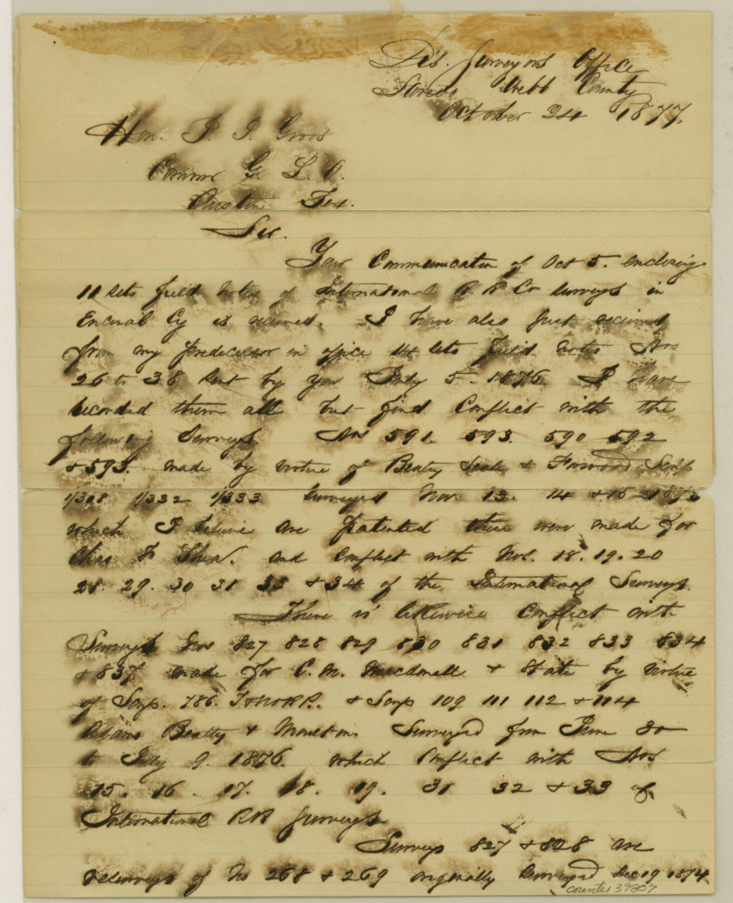
[Surveyor's statement regarding conflict between surveys near the Webb-La Salle County line]
-
Map/Doc
39807
-
Collection
General Map Collection
-
Object Dates
10/24/1877 (Creation Date)
-
People and Organizations
Samuel M. Jarvis (Surveyor/Engineer)
-
Counties
Webb La Salle
-
Subjects
Surveying Sketch File
-
Height x Width
10.0 x 8.2 inches
25.4 x 20.8 cm
-
Medium
paper, manuscript
Part of: General Map Collection
McCulloch County Rolled Sketch 5

Print $20.00
- Digital $50.00
McCulloch County Rolled Sketch 5
Size 25.7 x 20.9 inches
Map/Doc 6716
Travis County Sketch File 68

Print $20.00
- Digital $50.00
Travis County Sketch File 68
1949
Size 24.9 x 26.0 inches
Map/Doc 12475
Nueces County Sketch File 29

Print $40.00
- Digital $50.00
Nueces County Sketch File 29
1907
Size 17.2 x 14.2 inches
Map/Doc 32598
Jim Wells County Working Sketch 10

Print $20.00
- Digital $50.00
Jim Wells County Working Sketch 10
1952
Size 18.7 x 17.8 inches
Map/Doc 66608
Lampasas County Working Sketch 11

Print $20.00
- Digital $50.00
Lampasas County Working Sketch 11
1964
Size 38.3 x 42.8 inches
Map/Doc 70288
Sterling County Sketch File 14

Print $20.00
- Digital $50.00
Sterling County Sketch File 14
Size 18.9 x 16.4 inches
Map/Doc 12360
Harris County Sketch File 11

Print $18.00
- Digital $50.00
Harris County Sketch File 11
1895
Size 11.3 x 8.8 inches
Map/Doc 25342
Zapata County Working Sketch 11

Print $20.00
- Digital $50.00
Zapata County Working Sketch 11
1958
Size 38.1 x 28.7 inches
Map/Doc 62062
Reeves County

Print $20.00
- Digital $50.00
Reeves County
1903
Size 47.3 x 35.6 inches
Map/Doc 66997
Kerr County Sketch File 5

Print $4.00
- Digital $50.00
Kerr County Sketch File 5
1878
Size 14.2 x 8.4 inches
Map/Doc 28865
Rio Grande Rectification Project, El Paso and Juarez Valley

Print $20.00
- Digital $50.00
Rio Grande Rectification Project, El Paso and Juarez Valley
1935
Size 10.7 x 29.7 inches
Map/Doc 60863
Flight Mission No. CLL-1N, Frame 191, Willacy County

Print $20.00
- Digital $50.00
Flight Mission No. CLL-1N, Frame 191, Willacy County
1954
Size 18.3 x 22.0 inches
Map/Doc 87061
You may also like
Terrell County Rolled Sketch 45

Print $40.00
- Digital $50.00
Terrell County Rolled Sketch 45
1953
Size 33.5 x 51.7 inches
Map/Doc 9991
Newton County Sketch File 17

Print $3.00
- Digital $50.00
Newton County Sketch File 17
1884
Size 15.5 x 10.6 inches
Map/Doc 32392
Map of Newton Co.

Print $20.00
- Digital $50.00
Map of Newton Co.
1918
Size 46.4 x 39.4 inches
Map/Doc 81987
Grayson County Working Sketch 3

Print $20.00
- Digital $50.00
Grayson County Working Sketch 3
1939
Size 28.2 x 40.5 inches
Map/Doc 63242
Houston County Sketch File 41

Print $6.00
- Digital $50.00
Houston County Sketch File 41
1845
Size 16.0 x 10.2 inches
Map/Doc 26828
Right of Way and Track Map, Houston & Texas Central R.R. operated by the T. and N. O. R.R., Fort Worth Branch

Print $40.00
- Digital $50.00
Right of Way and Track Map, Houston & Texas Central R.R. operated by the T. and N. O. R.R., Fort Worth Branch
1918
Size 30.7 x 57.3 inches
Map/Doc 64782
Reeves County Working Sketch 5

Print $20.00
- Digital $50.00
Reeves County Working Sketch 5
1938
Size 38.0 x 32.4 inches
Map/Doc 63448
Atascosa County Sketch File 13

Print $4.00
- Digital $50.00
Atascosa County Sketch File 13
1867
Size 12.8 x 8.2 inches
Map/Doc 13771
Intracoastal Waterway in Texas - Corpus Christi to Point Isabel including Arroyo Colorado to Mo. Pac. R.R. Bridge Near Harlingen

Print $20.00
- Digital $50.00
Intracoastal Waterway in Texas - Corpus Christi to Point Isabel including Arroyo Colorado to Mo. Pac. R.R. Bridge Near Harlingen
1933
Size 28.0 x 41.0 inches
Map/Doc 61875
Waller County Sketch File 3

Print $4.00
- Digital $50.00
Waller County Sketch File 3
Size 13.0 x 8.4 inches
Map/Doc 39598
Amistad International Reservoir on Rio Grande 64

Print $20.00
- Digital $50.00
Amistad International Reservoir on Rio Grande 64
1949
Size 28.4 x 39.6 inches
Map/Doc 73349
The Federal Aid Highway System Progress Map

Print $20.00
The Federal Aid Highway System Progress Map
1931
Size 31.4 x 22.1 inches
Map/Doc 79745