Orange County NRC Article 33.136 Sketch 6

Print $42.00
Orange County NRC Article 33.136 Sketch 6
2025
97430
Orange County NRC Article 33.136 Sketch 5

Print $62.00
- Digital $50.00
Orange County NRC Article 33.136 Sketch 5
2014
Size: 26.1 x 22.7 inches
94946
Orange County NRC Article 33.136 Sketch 4

Print $24.00
- Digital $50.00
Orange County NRC Article 33.136 Sketch 4
2011
Size: 22.6 x 31.2 inches
93271
Orange County NRC Article 33.136 Sketch 3

Print $16.00
- Digital $50.00
Orange County NRC Article 33.136 Sketch 3
2011
Size: 11.0 x 8.5 inches
93267
Orange County NRC Article 33.136 Sketch 2

Print $9.00
- Digital $50.00
Orange County NRC Article 33.136 Sketch 2
2011
Size: 9.7 x 15.5 inches
93263
Orange County Working Sketch 54a

Print $40.00
- Digital $50.00
Orange County Working Sketch 54a
2008
Size: 22.9 x 48.0 inches
88742
Orange County Working Sketch 54b

Print $40.00
- Digital $50.00
Orange County Working Sketch 54b
2008
Size: 38.0 x 50.3 inches
88743
Orange County Working Sketch 53

Print $20.00
- Digital $50.00
Orange County Working Sketch 53
2007
Size: 34.1 x 46.0 inches
87371
Orange County Working Sketch 52

Print $20.00
- Digital $50.00
Orange County Working Sketch 52
2006
Size: 31.9 x 47.5 inches
83069
Orange County NRC Article 33.136 Sketch 1

Print $20.00
- Digital $50.00
Orange County NRC Article 33.136 Sketch 1
2004
Size: 23.8 x 34.5 inches
81979
Sabine Pass and Lake

Print $40.00
- Digital $50.00
Sabine Pass and Lake
1992
Size: 49.2 x 28.6 inches
69828
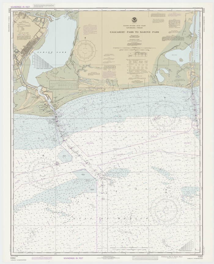
Calcasieu Pass to Sabine Pass

Print $20.00
- Digital $50.00
Calcasieu Pass to Sabine Pass
1992
Size: 44.5 x 35.8 inches
69815
Orange County Working Sketch 51

Print $20.00
- Digital $50.00
Orange County Working Sketch 51
1992
Size: 29.6 x 22.0 inches
71383
Orange County Working Sketch 50

Print $20.00
- Digital $50.00
Orange County Working Sketch 50
1991
Size: 36.0 x 43.6 inches
71382
Orange County Working Sketch 49

Print $20.00
- Digital $50.00
Orange County Working Sketch 49
1991
Size: 29.7 x 31.8 inches
71381
Orange County Working Sketch 48

Print $20.00
- Digital $50.00
Orange County Working Sketch 48
1991
Size: 13.3 x 19.9 inches
71380
Sabine and Neches Rivers

Print $20.00
- Digital $50.00
Sabine and Neches Rivers
1987
Size: 19.6 x 44.7 inches
69820
Orange County Working Sketch 47

Print $20.00
- Digital $50.00
Orange County Working Sketch 47
1987
Size: 27.5 x 26.5 inches
71379
Mississippi River to Galveston

Print $40.00
- Digital $50.00
Mississippi River to Galveston
1986
Size: 36.8 x 49.9 inches
69948
Orange County Rolled Sketch 32

Print $20.00
- Digital $50.00
Orange County Rolled Sketch 32
1982
Size: 33.6 x 22.5 inches
7188
Calcasieu Pass to Sabine Pass
Print $20.00
- Digital $50.00
Calcasieu Pass to Sabine Pass
1982
Size: 45.0 x 36.6 inches
69814
Orange County Working Sketch 45

Print $20.00
- Digital $50.00
Orange County Working Sketch 45
1982
Size: 25.6 x 24.2 inches
71377
Orange County Working Sketch 46

Print $3.00
- Digital $50.00
Orange County Working Sketch 46
1982
Size: 10.8 x 9.9 inches
71378
Orange County Working Sketch 44

Print $20.00
- Digital $50.00
Orange County Working Sketch 44
1980
Size: 16.5 x 22.0 inches
71376
Orange County Working Sketch 43

Print $20.00
- Digital $50.00
Orange County Working Sketch 43
1980
Size: 18.3 x 18.4 inches
71375
Orange County Working Sketch 41

Print $20.00
- Digital $50.00
Orange County Working Sketch 41
1979
Size: 28.0 x 18.2 inches
71373
Orange County Working Sketch 42

Print $20.00
- Digital $50.00
Orange County Working Sketch 42
1979
Size: 19.6 x 25.4 inches
71374
Orange County Working Sketch 40

Print $20.00
- Digital $50.00
Orange County Working Sketch 40
1979
Size: 19.2 x 12.1 inches
71372
Revised map of west half of Sabine Lake and Sabine Pass, showing subdivision for mineral development; Jefferson and Orange Counties

Print $40.00
- Digital $50.00
Revised map of west half of Sabine Lake and Sabine Pass, showing subdivision for mineral development; Jefferson and Orange Counties
1979
Size: 72.1 x 41.5 inches
1935
Calcasieu Pass to Sabine Pass

Print $20.00
- Digital $50.00
Calcasieu Pass to Sabine Pass
1976
Size: 44.6 x 35.3 inches
69813
Orange County NRC Article 33.136 Sketch 6
Print $42.00
Orange County NRC Article 33.136 Sketch 6
2025
-
Map/Doc
97430
-
Creation Date
2025
Orange County NRC Article 33.136 Sketch 5
Print $62.00
- Digital $50.00
Orange County NRC Article 33.136 Sketch 5
2014
-
Size
26.1 x 22.7 inches
-
Map/Doc
94946
-
Creation Date
2014
Orange County NRC Article 33.136 Sketch 4
Print $24.00
- Digital $50.00
Orange County NRC Article 33.136 Sketch 4
2011
-
Size
22.6 x 31.2 inches
-
Map/Doc
93271
-
Creation Date
2011
Orange County NRC Article 33.136 Sketch 3
Print $16.00
- Digital $50.00
Orange County NRC Article 33.136 Sketch 3
2011
-
Size
11.0 x 8.5 inches
-
Map/Doc
93267
-
Creation Date
2011
Orange County NRC Article 33.136 Sketch 2
Print $9.00
- Digital $50.00
Orange County NRC Article 33.136 Sketch 2
2011
-
Size
9.7 x 15.5 inches
-
Map/Doc
93263
-
Creation Date
2011
Orange County Working Sketch 54a
Print $40.00
- Digital $50.00
Orange County Working Sketch 54a
2008
-
Size
22.9 x 48.0 inches
-
Map/Doc
88742
-
Creation Date
2008
Orange County Working Sketch 54b
Print $40.00
- Digital $50.00
Orange County Working Sketch 54b
2008
-
Size
38.0 x 50.3 inches
-
Map/Doc
88743
-
Creation Date
2008
Orange County Working Sketch 53
Print $20.00
- Digital $50.00
Orange County Working Sketch 53
2007
-
Size
34.1 x 46.0 inches
-
Map/Doc
87371
-
Creation Date
2007
Orange County Working Sketch 52
Print $20.00
- Digital $50.00
Orange County Working Sketch 52
2006
-
Size
31.9 x 47.5 inches
-
Map/Doc
83069
-
Creation Date
2006
Orange County NRC Article 33.136 Sketch 1
Print $20.00
- Digital $50.00
Orange County NRC Article 33.136 Sketch 1
2004
-
Size
23.8 x 34.5 inches
-
Map/Doc
81979
-
Creation Date
2004
Sabine Pass and Lake
Print $40.00
- Digital $50.00
Sabine Pass and Lake
1992
-
Size
49.2 x 28.6 inches
-
Map/Doc
69828
-
Creation Date
1992
Calcasieu Pass to Sabine Pass
Print $20.00
- Digital $50.00
Calcasieu Pass to Sabine Pass
1992
-
Size
44.5 x 35.8 inches
-
Map/Doc
69815
-
Creation Date
1992
Orange County Working Sketch 51
Print $20.00
- Digital $50.00
Orange County Working Sketch 51
1992
-
Size
29.6 x 22.0 inches
-
Map/Doc
71383
-
Creation Date
1992
Orange County Working Sketch 50
Print $20.00
- Digital $50.00
Orange County Working Sketch 50
1991
-
Size
36.0 x 43.6 inches
-
Map/Doc
71382
-
Creation Date
1991
Orange County Working Sketch 49
Print $20.00
- Digital $50.00
Orange County Working Sketch 49
1991
-
Size
29.7 x 31.8 inches
-
Map/Doc
71381
-
Creation Date
1991
Orange County Working Sketch 48
Print $20.00
- Digital $50.00
Orange County Working Sketch 48
1991
-
Size
13.3 x 19.9 inches
-
Map/Doc
71380
-
Creation Date
1991
Sabine and Neches Rivers
Print $20.00
- Digital $50.00
Sabine and Neches Rivers
1987
-
Size
19.6 x 44.7 inches
-
Map/Doc
69820
-
Creation Date
1987
Orange County Working Sketch 47
Print $20.00
- Digital $50.00
Orange County Working Sketch 47
1987
-
Size
27.5 x 26.5 inches
-
Map/Doc
71379
-
Creation Date
1987
Mississippi River to Galveston
Print $40.00
- Digital $50.00
Mississippi River to Galveston
1986
-
Size
36.8 x 49.9 inches
-
Map/Doc
69948
-
Creation Date
1986
Orange County Rolled Sketch 32
Print $20.00
- Digital $50.00
Orange County Rolled Sketch 32
1982
-
Size
33.6 x 22.5 inches
-
Map/Doc
7188
-
Creation Date
1982
Calcasieu Pass to Sabine Pass
Print $20.00
- Digital $50.00
Calcasieu Pass to Sabine Pass
1982
-
Size
45.0 x 36.6 inches
-
Map/Doc
69814
-
Creation Date
1982
Orange County Working Sketch 45
Print $20.00
- Digital $50.00
Orange County Working Sketch 45
1982
-
Size
25.6 x 24.2 inches
-
Map/Doc
71377
-
Creation Date
1982
Orange County Working Sketch 46
Print $3.00
- Digital $50.00
Orange County Working Sketch 46
1982
-
Size
10.8 x 9.9 inches
-
Map/Doc
71378
-
Creation Date
1982
Orange County Working Sketch 44
Print $20.00
- Digital $50.00
Orange County Working Sketch 44
1980
-
Size
16.5 x 22.0 inches
-
Map/Doc
71376
-
Creation Date
1980
Orange County Working Sketch 43
Print $20.00
- Digital $50.00
Orange County Working Sketch 43
1980
-
Size
18.3 x 18.4 inches
-
Map/Doc
71375
-
Creation Date
1980
Orange County Working Sketch 41
Print $20.00
- Digital $50.00
Orange County Working Sketch 41
1979
-
Size
28.0 x 18.2 inches
-
Map/Doc
71373
-
Creation Date
1979
Orange County Working Sketch 42
Print $20.00
- Digital $50.00
Orange County Working Sketch 42
1979
-
Size
19.6 x 25.4 inches
-
Map/Doc
71374
-
Creation Date
1979
Orange County Working Sketch 40
Print $20.00
- Digital $50.00
Orange County Working Sketch 40
1979
-
Size
19.2 x 12.1 inches
-
Map/Doc
71372
-
Creation Date
1979
Revised map of west half of Sabine Lake and Sabine Pass, showing subdivision for mineral development; Jefferson and Orange Counties
Print $40.00
- Digital $50.00
Revised map of west half of Sabine Lake and Sabine Pass, showing subdivision for mineral development; Jefferson and Orange Counties
1979
-
Size
72.1 x 41.5 inches
-
Map/Doc
1935
-
Creation Date
1979
Calcasieu Pass to Sabine Pass
Print $20.00
- Digital $50.00
Calcasieu Pass to Sabine Pass
1976
-
Size
44.6 x 35.3 inches
-
Map/Doc
69813
-
Creation Date
1976