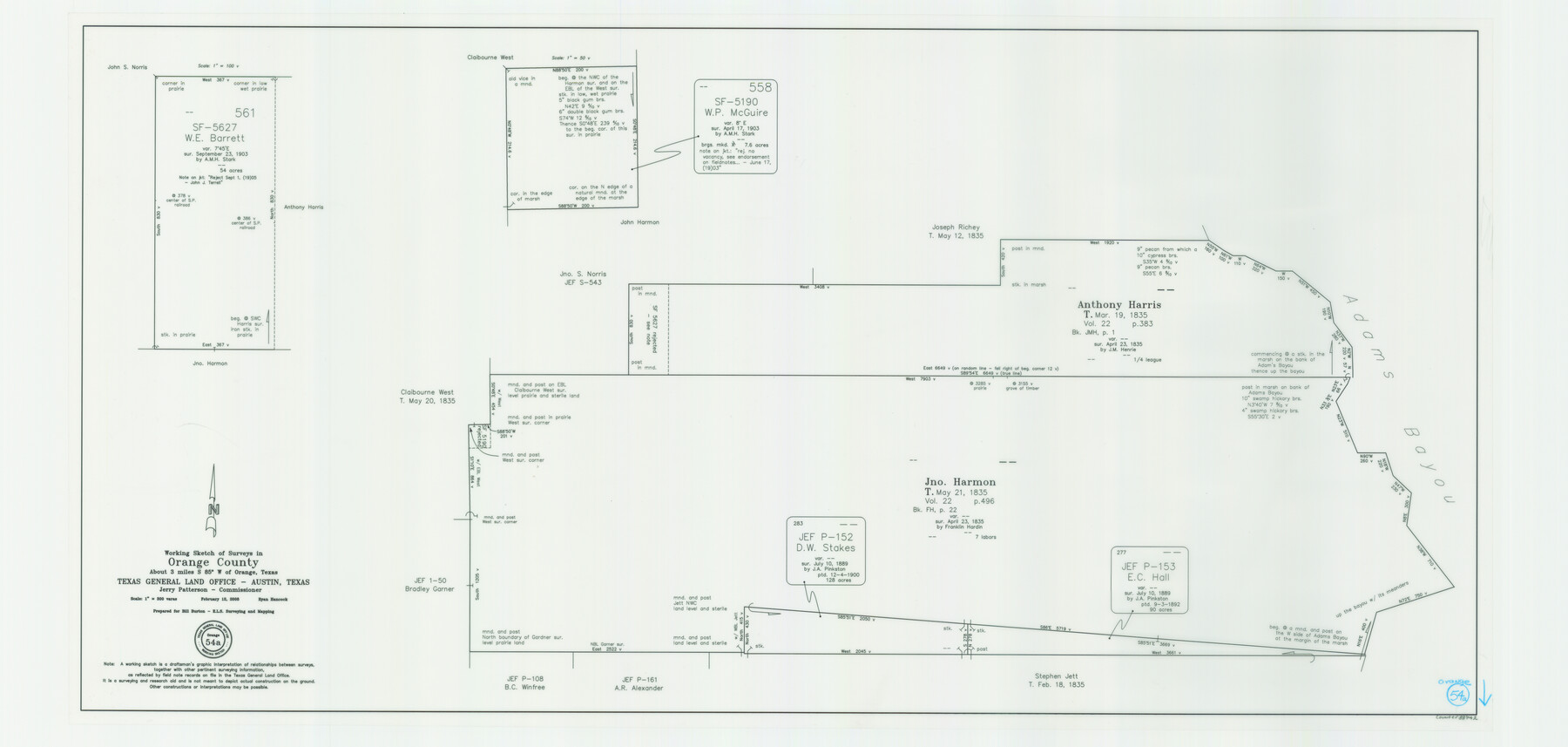
Orange County Working Sketch 54a
-
Map/Doc
88742
-
Collection
General Map Collection
-
Object Dates
2/12/2008 (Creation Date)
-
People and Organizations
Jerry E. Patterson (GLO Commissioner)
Ryan Hancock (Draftsman)
-
Counties
Orange
-
Subjects
Surveying Working Sketch
-
Height x Width
22.9 x 48.0 inches
58.2 x 121.9 cm
-
Scale
1" = 300 varas
-
Comments
Surveys located about three miles South 85 degrees West of Orange, Texas.
Part of: General Map Collection
Duval County Rolled Sketch Pressly No. 1A

Print $20.00
- Digital $50.00
Duval County Rolled Sketch Pressly No. 1A
1935
Size 25.4 x 37.6 inches
Map/Doc 5769
Trinity County Working Sketch 4

Print $20.00
- Digital $50.00
Trinity County Working Sketch 4
1908
Size 21.3 x 18.5 inches
Map/Doc 69452
Gulf of Mexico

Print $20.00
- Digital $50.00
Gulf of Mexico
1900
Size 18.2 x 28.0 inches
Map/Doc 72648
Northwest Part Crockett County

Print $20.00
- Digital $50.00
Northwest Part Crockett County
1983
Size 29.9 x 39.1 inches
Map/Doc 77252
Roberts County Working Sketch 20

Print $20.00
- Digital $50.00
Roberts County Working Sketch 20
1977
Size 25.6 x 32.9 inches
Map/Doc 63546
Dickens County Sketch File 22

Print $8.00
- Digital $50.00
Dickens County Sketch File 22
1913
Size 11.2 x 9.1 inches
Map/Doc 20985
Montague County Working Sketch 27

Print $20.00
- Digital $50.00
Montague County Working Sketch 27
1956
Size 35.8 x 24.9 inches
Map/Doc 71093
Wise County Sketch File 51

Print $2.00
- Digital $50.00
Wise County Sketch File 51
Size 8.5 x 3.9 inches
Map/Doc 40618
Sutton County Sketch File 52

Print $6.00
- Digital $50.00
Sutton County Sketch File 52
1948
Size 11.2 x 8.8 inches
Map/Doc 37529
Starr County Rolled Sketch 30

Print $20.00
- Digital $50.00
Starr County Rolled Sketch 30
1941
Size 14.9 x 21.5 inches
Map/Doc 7813
Nueces County Rolled Sketch 130

Print $20.00
- Digital $50.00
Nueces County Rolled Sketch 130
2000
Size 17.2 x 23.8 inches
Map/Doc 7165
You may also like

Brazos River, Brazos River Sheet 6

Print $4.00
- Digital $50.00
Brazos River, Brazos River Sheet 6
1926
Size 29.0 x 24.3 inches
Map/Doc 65299

Chambers County Rolled Sketch 26

Print $20.00
- Digital $50.00
Chambers County Rolled Sketch 26
1947
Size 12.7 x 19.9 inches
Map/Doc 5428
Fisher County Rolled Sketch 7

Print $20.00
- Digital $50.00
Fisher County Rolled Sketch 7
1873
Size 47.1 x 43.5 inches
Map/Doc 8891
Flight Mission No. DCL-7C, Frame 40, Kenedy County

Print $20.00
- Digital $50.00
Flight Mission No. DCL-7C, Frame 40, Kenedy County
1943
Size 15.4 x 15.2 inches
Map/Doc 86028
Glasscock County Sketch File 5

Print $20.00
- Digital $50.00
Glasscock County Sketch File 5
1929
Size 23.0 x 22.7 inches
Map/Doc 11561
Shackelford County Sketch File 2

Print $4.00
- Digital $50.00
Shackelford County Sketch File 2
1870
Size 9.3 x 9.0 inches
Map/Doc 36572
Reeves County Rolled Sketch 10

Print $20.00
- Digital $50.00
Reeves County Rolled Sketch 10
Size 22.4 x 42.0 inches
Map/Doc 7480
Val Verde County Sketch File M

Print $18.00
- Digital $50.00
Val Verde County Sketch File M
1920
Size 14.5 x 9.1 inches
Map/Doc 39275
Erath County Working Sketch 32

Print $20.00
- Digital $50.00
Erath County Working Sketch 32
1971
Size 32.0 x 25.8 inches
Map/Doc 69113
Angelina River, Mud Creek, Sheet 2

Print $4.00
- Digital $50.00
Angelina River, Mud Creek, Sheet 2
1937
Size 26.4 x 18.9 inches
Map/Doc 65076