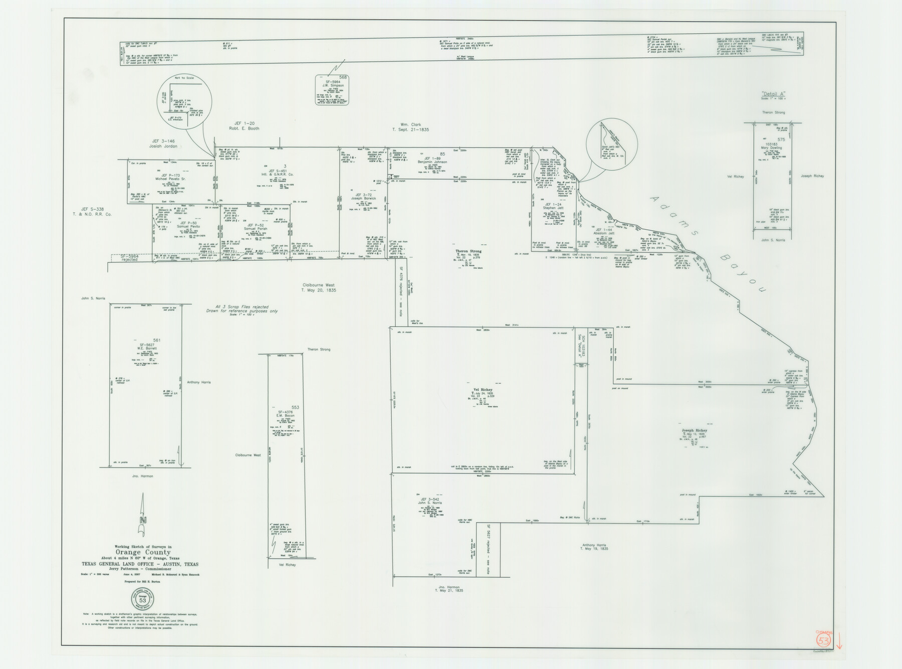
Orange County Working Sketch 53
-
Map/Doc
87371
-
Collection
General Map Collection
-
Object Dates
6/4/2007 (Creation Date)
-
People and Organizations
Jerry E. Patterson (GLO Commissioner)
Ryan Hancock (Draftsman)
Michael Mokarzel (Draftsman)
-
Counties
Orange
-
Subjects
Surveying Working Sketch
-
Height x Width
34.1 x 46.0 inches
86.6 x 116.8 cm
-
Scale
1" = 300 varas
-
Comments
Surveys located about 4 miles North 60 degrees West of Orange, Texas.
Part of: General Map Collection
Haskell County Rolled Sketch 10

Print $20.00
- Digital $50.00
Haskell County Rolled Sketch 10
1981
Size 33.2 x 14.3 inches
Map/Doc 6169

Webb County Working Sketch 78

Print $20.00
- Digital $50.00
Webb County Working Sketch 78
1977
Size 35.0 x 42.1 inches
Map/Doc 72445
Grant of Miguel Rabago

Print $2.00
- Digital $50.00
Grant of Miguel Rabago
Size 8.6 x 8.4 inches
Map/Doc 76047
Post Route Map of the State of Texas, Showing Post Offices with the Intermediate Distances on Mail Routes

Print $40.00
- Digital $50.00
Post Route Map of the State of Texas, Showing Post Offices with the Intermediate Distances on Mail Routes
1908
Size 52.5 x 35.1 inches
Map/Doc 3163

Sutton County Boundary File 3

Print $22.00
- Digital $50.00
Sutton County Boundary File 3
Size 14.2 x 8.7 inches
Map/Doc 59024
Oldham County Sketch File 4

Print $20.00
- Digital $50.00
Oldham County Sketch File 4
1883
Size 13.7 x 22.5 inches
Map/Doc 12111
Flight Mission No. DAH-9M, Frame 158, Orange County

Print $20.00
- Digital $50.00
Flight Mission No. DAH-9M, Frame 158, Orange County
1953
Size 18.4 x 22.3 inches
Map/Doc 86857
Matagorda County Rolled Sketch 37A

Print $40.00
- Digital $50.00
Matagorda County Rolled Sketch 37A
Size 48.7 x 41.1 inches
Map/Doc 10195
Flight Mission No. DQO-11K, Frame 20, Galveston County

Print $20.00
- Digital $50.00
Flight Mission No. DQO-11K, Frame 20, Galveston County
1952
Size 18.8 x 22.4 inches
Map/Doc 85215
Topographical Map of the Rio Grande, Sheet No. 16

Print $20.00
- Digital $50.00
Topographical Map of the Rio Grande, Sheet No. 16
1912
Map/Doc 89540
You may also like
Culberson County Rolled Sketch 23

Print $20.00
- Digital $50.00
Culberson County Rolled Sketch 23
1888
Size 24.1 x 35.2 inches
Map/Doc 5655
Henderson County Working Sketch 39

Print $20.00
- Digital $50.00
Henderson County Working Sketch 39
1982
Size 24.3 x 19.0 inches
Map/Doc 66172
Andrews County Rolled Sketch 15

Print $20.00
- Digital $50.00
Andrews County Rolled Sketch 15
1934
Size 27.9 x 22.4 inches
Map/Doc 77166
Upshur County Sketch File 22

Print $8.00
- Digital $50.00
Upshur County Sketch File 22
2015
Size 11.0 x 8.5 inches
Map/Doc 93774
[University Lands in El Paso County]
![2426, [University Lands in El Paso County], General Map Collection](https://historictexasmaps.com/wmedia_w700/maps/2426.tif.jpg)
Print $20.00
- Digital $50.00
[University Lands in El Paso County]
1886
Size 29.0 x 43.4 inches
Map/Doc 2426
Harrison County Sketch File 9

Print $4.00
- Digital $50.00
Harrison County Sketch File 9
1862
Size 8.3 x 11.1 inches
Map/Doc 26048

Brazos River, Koy Bridge Sheet/Mill Creek

Print $20.00
- Digital $50.00
Brazos River, Koy Bridge Sheet/Mill Creek
1933
Size 44.0 x 27.3 inches
Map/Doc 65290
Galveston County NRC Article 33.136 Sketch 97

Print $414.00
Galveston County NRC Article 33.136 Sketch 97
2024
Map/Doc 97407
[McLennan County School Land Leagues Nos. 3 and 4]
![90879, [McLennan County School Land Leagues Nos. 3 and 4], Twichell Survey Records](https://historictexasmaps.com/wmedia_w700/maps/90879-2.tif.jpg)
Print $20.00
- Digital $50.00
[McLennan County School Land Leagues Nos. 3 and 4]
1919
Size 9.1 x 18.6 inches
Map/Doc 90879
Palo Pinto County Working Sketch 22

Print $20.00
- Digital $50.00
Palo Pinto County Working Sketch 22
1985
Map/Doc 71405
Palo Pinto County

Print $40.00
- Digital $50.00
Palo Pinto County
1941
Size 49.4 x 40.4 inches
Map/Doc 95606