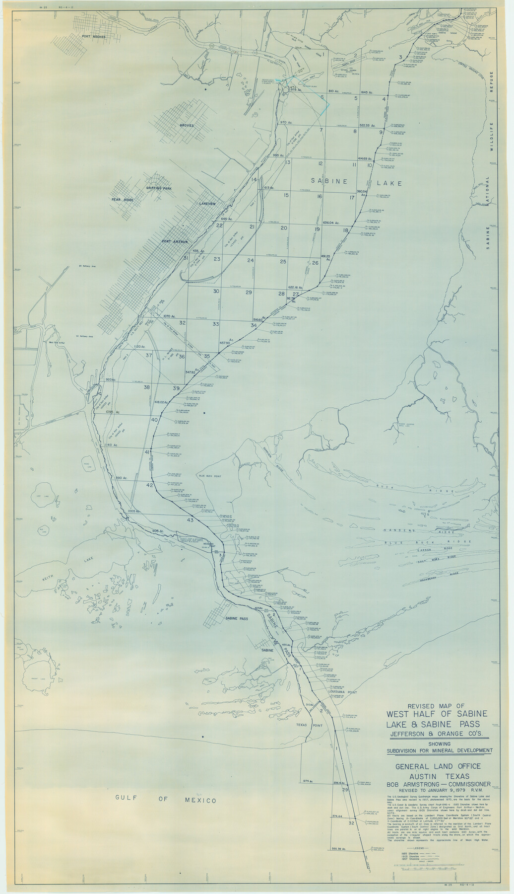
Revised map of west half of Sabine Lake and Sabine Pass, showing subdivision for mineral development; Jefferson and Orange Counties
-
Map/Doc
1935
-
Collection
General Map Collection
-
Object Dates
1/9/1979 (Creation Date)
-
People and Organizations
General Land Office (Publisher)
-
Counties
Jefferson Orange
-
Subjects
Energy Offshore Submerged Area
-
Height x Width
72.1 x 41.5 inches
183.1 x 105.4 cm
-
Medium
tracing
-
Scale
1" = 2000 feet
-
Comments
Gulf coast and submerged state lands. Revised January 9, 1979.
"#25" and "RG-4-12" in lower right and upper left margins.
Part of: General Map Collection
Map of section no. 4 of a survey of Padre Island made for the Office of the Attorney General of the State of Texas

Print $40.00
- Digital $50.00
Map of section no. 4 of a survey of Padre Island made for the Office of the Attorney General of the State of Texas
1941
Size 82.6 x 40.8 inches
Map/Doc 2260
Nacogdoches County Working Sketch 4

Print $20.00
- Digital $50.00
Nacogdoches County Working Sketch 4
1946
Size 22.2 x 23.2 inches
Map/Doc 71220
Map of Tyler County

Print $20.00
- Digital $50.00
Map of Tyler County
1863
Size 21.0 x 22.3 inches
Map/Doc 4099
Kerr County Boundary File 2

Print $46.00
- Digital $50.00
Kerr County Boundary File 2
Size 15.6 x 26.5 inches
Map/Doc 55984
Cottle County Working Sketch 20

Print $20.00
- Digital $50.00
Cottle County Working Sketch 20
1982
Size 19.9 x 37.0 inches
Map/Doc 68330
Rains County Working Sketch Graphic Index

Print $20.00
- Digital $50.00
Rains County Working Sketch Graphic Index
1942
Size 31.3 x 29.5 inches
Map/Doc 76675
Hutchinson County Rolled Sketch 43

Print $40.00
- Digital $50.00
Hutchinson County Rolled Sketch 43
1992
Size 38.0 x 49.4 inches
Map/Doc 6311
Cottle County Working Sketch 12

Print $20.00
- Digital $50.00
Cottle County Working Sketch 12
1959
Size 39.1 x 25.7 inches
Map/Doc 68322
Kimble County Working Sketch 93

Print $20.00
- Digital $50.00
Kimble County Working Sketch 93
1983
Size 31.5 x 37.8 inches
Map/Doc 70161
Liberty County Working Sketch 68

Print $20.00
- Digital $50.00
Liberty County Working Sketch 68
1972
Size 27.4 x 24.6 inches
Map/Doc 70528
West Part of Jeff Davis Co.

Print $20.00
- Digital $50.00
West Part of Jeff Davis Co.
1977
Size 31.0 x 41.1 inches
Map/Doc 77328
McCulloch County Working Sketch 1

Print $20.00
- Digital $50.00
McCulloch County Working Sketch 1
1944
Size 29.8 x 29.9 inches
Map/Doc 70676
You may also like
La Salle County

Print $20.00
- Digital $50.00
La Salle County
1923
Size 47.5 x 42.5 inches
Map/Doc 73215
Flight Mission No. CRK-3P, Frame 125, Refugio County

Print $20.00
- Digital $50.00
Flight Mission No. CRK-3P, Frame 125, Refugio County
1956
Size 18.5 x 22.5 inches
Map/Doc 86913
Upton County Rolled Sketch 2

Print $20.00
- Digital $50.00
Upton County Rolled Sketch 2
1884
Size 26.2 x 36.1 inches
Map/Doc 8065
Flight Mission No. CUG-3P, Frame 160, Kleberg County

Print $20.00
- Digital $50.00
Flight Mission No. CUG-3P, Frame 160, Kleberg County
1956
Size 18.4 x 22.1 inches
Map/Doc 86280
Lee County Boundary File 2

Print $25.00
- Digital $50.00
Lee County Boundary File 2
Size 14.2 x 8.6 inches
Map/Doc 56269
Rains County Working Sketch 11

Print $20.00
- Digital $50.00
Rains County Working Sketch 11
Size 40.1 x 35.1 inches
Map/Doc 71837
Blanco County Boundary File 7

Print $58.00
- Digital $50.00
Blanco County Boundary File 7
Size 14.3 x 8.5 inches
Map/Doc 50565
Duval County Boundary File 3h

Print $4.00
- Digital $50.00
Duval County Boundary File 3h
Size 10.0 x 8.0 inches
Map/Doc 52749
Duval County Working Sketch 56

Print $20.00
- Digital $50.00
Duval County Working Sketch 56
1989
Size 26.7 x 27.2 inches
Map/Doc 68780
Outer Continental Shelf Leasing Maps (Louisiana Offshore Operations)

Print $20.00
- Digital $50.00
Outer Continental Shelf Leasing Maps (Louisiana Offshore Operations)
1954
Size 16.2 x 16.3 inches
Map/Doc 76107
Newton County Working Sketch 45

Print $20.00
- Digital $50.00
Newton County Working Sketch 45
1996
Size 16.4 x 24.0 inches
Map/Doc 71291
[West half of County]
![93188, [West half of County], Twichell Survey Records](https://historictexasmaps.com/wmedia_w700/maps/93188-1.tif.jpg)
Print $40.00
- Digital $50.00
[West half of County]
1914
Size 38.7 x 97.9 inches
Map/Doc 93188