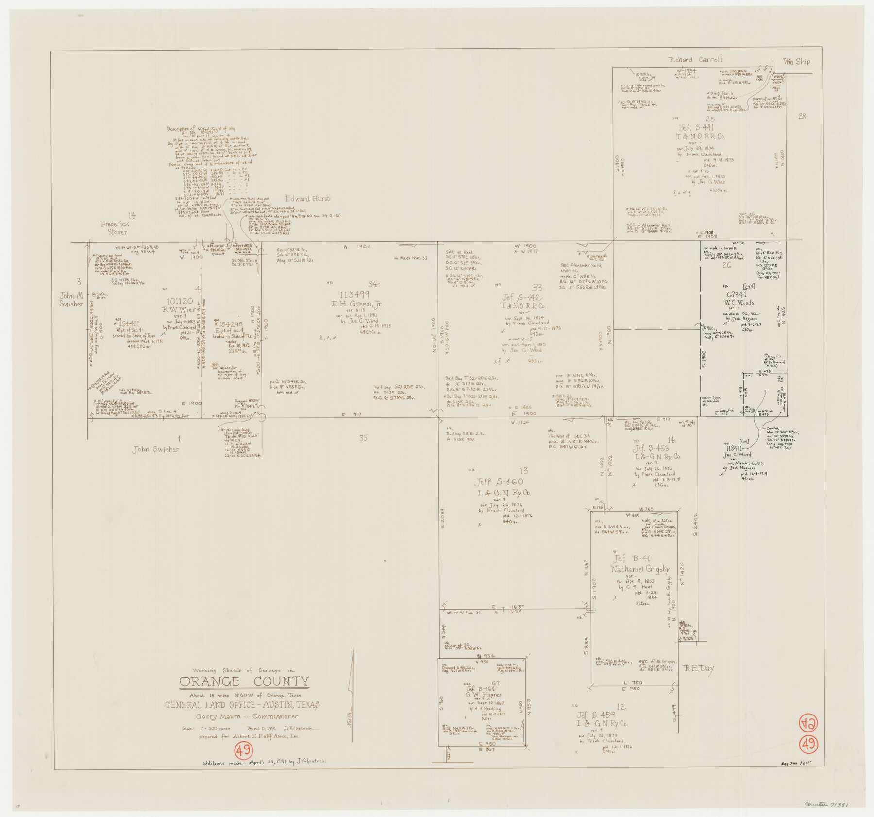
Orange County Working Sketch 49
-
Map/Doc
71381
-
Collection
General Map Collection
-
Object Dates
4/11/1991 (Creation Date)
-
People and Organizations
Joan Kilpatrick (Draftsman)
-
Counties
Orange
-
Subjects
Surveying Working Sketch
-
Height x Width
29.7 x 31.8 inches
75.4 x 80.8 cm
-
Scale
1" = 300 varas
Part of: General Map Collection
Lamb County Sketch File 12

Print $16.00
- Digital $50.00
Lamb County Sketch File 12
Size 8.6 x 7.7 inches
Map/Doc 29363
Webb County Working Sketch 64

Print $20.00
- Digital $50.00
Webb County Working Sketch 64
1962
Size 12.8 x 26.1 inches
Map/Doc 72430
Gaines County Rolled Sketch 13

Print $40.00
- Digital $50.00
Gaines County Rolled Sketch 13
Size 70.1 x 23.1 inches
Map/Doc 9029
Dickens County Working Sketch 2

Print $20.00
- Digital $50.00
Dickens County Working Sketch 2
1914
Size 19.1 x 16.6 inches
Map/Doc 68649
Crockett County Working Sketch 38

Print $20.00
- Digital $50.00
Crockett County Working Sketch 38
1928
Size 28.7 x 16.6 inches
Map/Doc 68371
Panola County Rolled Sketch 3

Print $1246.00
- Digital $50.00
Panola County Rolled Sketch 3
1949
Size 10.3 x 15.2 inches
Map/Doc 47978
Sectional Map No. 2 of the lands and the line of the Texas & Pacific Ry. Co. in Howard, Martin, Andrews, Midland and Tom Green Counties

Print $20.00
- Digital $50.00
Sectional Map No. 2 of the lands and the line of the Texas & Pacific Ry. Co. in Howard, Martin, Andrews, Midland and Tom Green Counties
1885
Size 19.1 x 23.3 inches
Map/Doc 4862
[Beaumont, Sour Lake and Western Ry. Right of Way and Alignment - Frisco]
![64129, [Beaumont, Sour Lake and Western Ry. Right of Way and Alignment - Frisco], General Map Collection](https://historictexasmaps.com/wmedia_w700/maps/64129.tif.jpg)
Print $20.00
- Digital $50.00
[Beaumont, Sour Lake and Western Ry. Right of Way and Alignment - Frisco]
1910
Size 20.1 x 45.9 inches
Map/Doc 64129
Kimble County Sketch File 26

Print $4.00
- Digital $50.00
Kimble County Sketch File 26
1912
Size 7.8 x 13.0 inches
Map/Doc 28969
Hansford County Boundary File 2

Print $14.00
- Digital $50.00
Hansford County Boundary File 2
Size 9.3 x 4.9 inches
Map/Doc 54245
[Surveys in Austin's Colony along Buffalo Bayou and the San Jacinto River]
![51, [Surveys in Austin's Colony along Buffalo Bayou and the San Jacinto River], General Map Collection](https://historictexasmaps.com/wmedia_w700/maps/51.tif.jpg)
Print $20.00
- Digital $50.00
[Surveys in Austin's Colony along Buffalo Bayou and the San Jacinto River]
1824
Size 23.7 x 17.6 inches
Map/Doc 51
Val Verde County Working Sketch 55

Print $20.00
- Digital $50.00
Val Verde County Working Sketch 55
1957
Size 20.1 x 28.6 inches
Map/Doc 72190
You may also like
Flight Mission No. DQN-5K, Frame 59, Calhoun County

Print $20.00
- Digital $50.00
Flight Mission No. DQN-5K, Frame 59, Calhoun County
1953
Size 18.7 x 22.3 inches
Map/Doc 84402
Tascotal Mesa Quadrangle

Print $20.00
- Digital $50.00
Tascotal Mesa Quadrangle
1917
Size 17.0 x 20.7 inches
Map/Doc 90134
Trinity River, Crandell Sheet/East Fork of Trinity River

Print $20.00
- Digital $50.00
Trinity River, Crandell Sheet/East Fork of Trinity River
1921
Size 42.0 x 35.5 inches
Map/Doc 65188
Baylor County Boundary File 2

Print $44.00
- Digital $50.00
Baylor County Boundary File 2
Size 8.9 x 25.9 inches
Map/Doc 50359
Armstrong County Sketch File 5

Print $40.00
- Digital $50.00
Armstrong County Sketch File 5
1887
Size 19.7 x 22.9 inches
Map/Doc 10841
Dickens County Working Sketch 10

Print $40.00
- Digital $50.00
Dickens County Working Sketch 10
1965
Size 62.2 x 39.5 inches
Map/Doc 68658
Presidio County Rolled Sketch 79

Print $20.00
- Digital $50.00
Presidio County Rolled Sketch 79
Size 22.2 x 27.0 inches
Map/Doc 7365
Il Texas: La Ferrovia New York Texas-Messicana, La Colonizzazione Italiana della costa del Texas

Print $20.00
- Digital $50.00
Il Texas: La Ferrovia New York Texas-Messicana, La Colonizzazione Italiana della costa del Texas
1881
Size 17.6 x 22.0 inches
Map/Doc 97406
Coast Chart No. 210 Aransas Pass and Corpus Christi Bay with the coast to latitude 27° 12' Texas

Print $20.00
- Digital $50.00
Coast Chart No. 210 Aransas Pass and Corpus Christi Bay with the coast to latitude 27° 12' Texas
1913
Size 26.8 x 18.2 inches
Map/Doc 72808
Flight Mission No. DQO-7K, Frame 102, Galveston County

Print $20.00
- Digital $50.00
Flight Mission No. DQO-7K, Frame 102, Galveston County
1952
Size 18.6 x 22.5 inches
Map/Doc 85117
The Chief Justice County of Victoria. September 20, 1837

Print $20.00
The Chief Justice County of Victoria. September 20, 1837
2020
Size 23.3 x 21.7 inches
Map/Doc 96075
Coleman County Working Sketch 10

Print $20.00
- Digital $50.00
Coleman County Working Sketch 10
1950
Size 30.1 x 29.1 inches
Map/Doc 68076