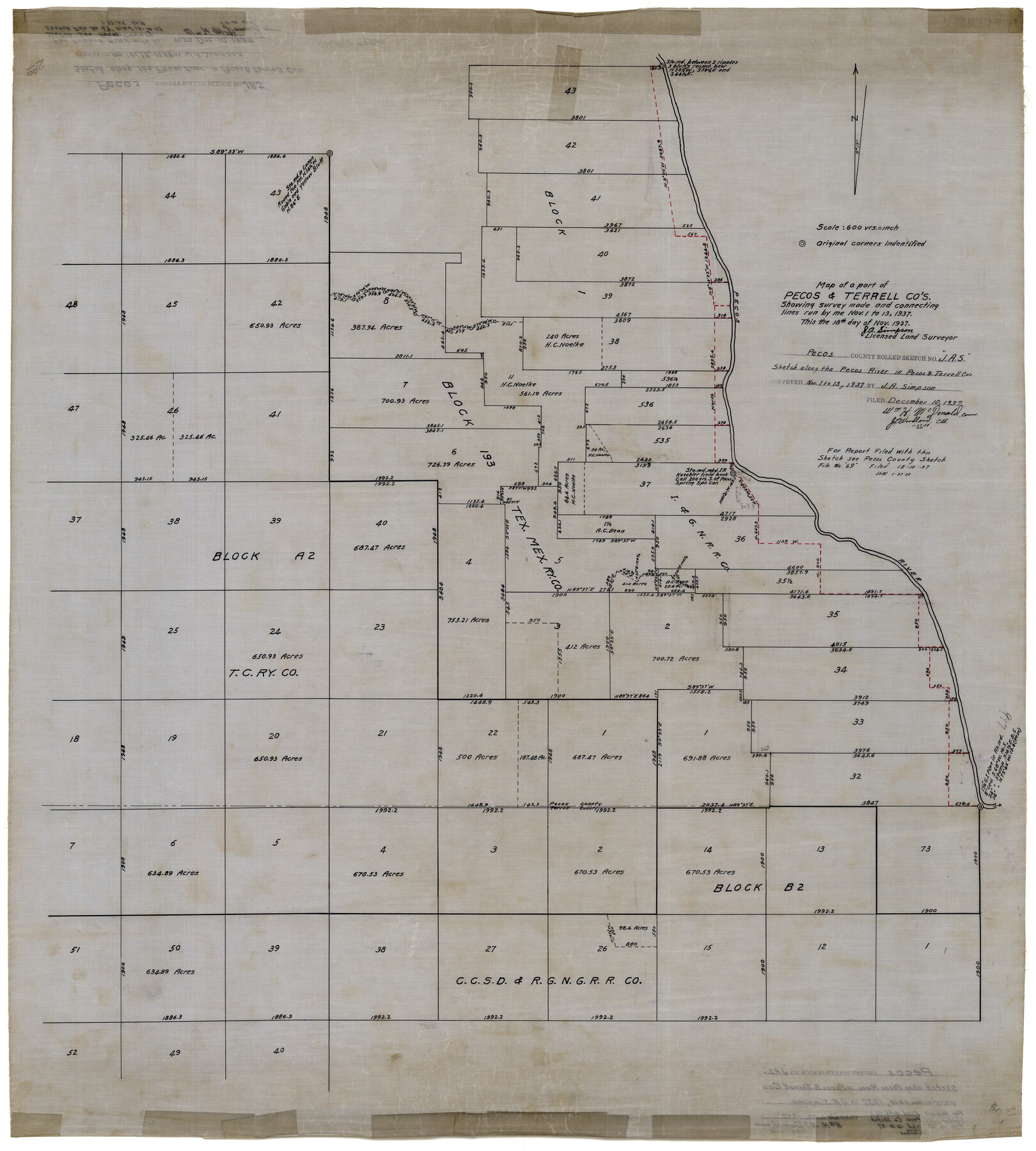
Pecos County Rolled Sketch JAS
Map of a part of Pecos & Terrell Cos. showing surveys made and connecting lines run
-
Map/Doc
9744
-
Collection
General Map Collection
-
Object Dates
1937/12/10 (File Date)
1937/11/18 (Creation Date)
1937/11/13 (Survey Date)
-
People and Organizations
J.A. Simpson (Surveyor/Engineer)
-
Counties
Pecos Terrell
-
Subjects
Surveying Rolled Sketch
-
Height x Width
34.9 x 31.4 inches
88.6 x 79.8 cm
-
Medium
linen, manuscript
-
Scale
1" = 600 varas
-
Comments
See Pecos County Sketch File 69 (33869) for report.
Related maps
Pecos County Sketch File 69

Print $6.00
- Digital $50.00
Pecos County Sketch File 69
Size 11.1 x 8.8 inches
Map/Doc 33869
Pecos County Rolled Sketch 159

Print $46.00
- Digital $50.00
Pecos County Rolled Sketch 159
1964
Size 31.9 x 38.3 inches
Map/Doc 7285
Part of: General Map Collection
Uvalde County Sketch File 12A

Print $20.00
- Digital $50.00
Uvalde County Sketch File 12A
1887
Size 19.2 x 30.0 inches
Map/Doc 12527
Fannin County Sketch File 22

Print $6.00
- Digital $50.00
Fannin County Sketch File 22
1883
Size 10.9 x 9.5 inches
Map/Doc 22489
Donley County Boundary File 9

Print $50.00
- Digital $50.00
Donley County Boundary File 9
1903
Size 13.0 x 8.1 inches
Map/Doc 62233
Lubbock County Sketch File 4 and A

Print $40.00
- Digital $50.00
Lubbock County Sketch File 4 and A
Size 22.7 x 29.8 inches
Map/Doc 12016
Flight Mission No. BQR-4K, Frame 62, Brazoria County

Print $20.00
- Digital $50.00
Flight Mission No. BQR-4K, Frame 62, Brazoria County
1952
Size 18.9 x 22.5 inches
Map/Doc 83995
Navigation Maps of Gulf Intracoastal Waterway, Port Arthur to Brownsville, Texas

Print $4.00
- Digital $50.00
Navigation Maps of Gulf Intracoastal Waterway, Port Arthur to Brownsville, Texas
1951
Size 16.7 x 21.5 inches
Map/Doc 65418
Andrews County Working Sketch 13

Print $20.00
- Digital $50.00
Andrews County Working Sketch 13
1956
Size 37.3 x 30.6 inches
Map/Doc 67059
Edwards County Working Sketch 113

Print $20.00
- Digital $50.00
Edwards County Working Sketch 113
1972
Size 39.1 x 36.0 inches
Map/Doc 68989
Presidio County Sketch File 63

Print $4.00
- Digital $50.00
Presidio County Sketch File 63
1939
Size 20.7 x 22.3 inches
Map/Doc 11718
Map of Kendall County

Print $20.00
- Digital $50.00
Map of Kendall County
1899
Size 36.7 x 34.4 inches
Map/Doc 4999
Controlled Mosaic by Jack Amman Photogrammetric Engineers, Inc - Sheet 14

Print $20.00
- Digital $50.00
Controlled Mosaic by Jack Amman Photogrammetric Engineers, Inc - Sheet 14
1954
Size 20.0 x 24.0 inches
Map/Doc 83458
Controlled Mosaic by Jack Amman Photogrammetric Engineers, Inc - Sheet 28

Print $20.00
- Digital $50.00
Controlled Mosaic by Jack Amman Photogrammetric Engineers, Inc - Sheet 28
1954
Size 21.1 x 24.1 inches
Map/Doc 83480
You may also like

Garza County Rolled Sketch 6B

Print $20.00
- Digital $50.00
Garza County Rolled Sketch 6B
Size 27.6 x 36.4 inches
Map/Doc 5996
Bivin's Addition to Amarillo, Texas, Survey 187, Block 2, A. B. & M., Potter County

Print $20.00
- Digital $50.00
Bivin's Addition to Amarillo, Texas, Survey 187, Block 2, A. B. & M., Potter County
Size 20.1 x 23.0 inches
Map/Doc 91739
Jackson County Sketch File 11

Print $20.00
- Digital $50.00
Jackson County Sketch File 11
1922
Size 15.7 x 30.1 inches
Map/Doc 11837

Sabine River, Toll Bridge Sheet

Print $40.00
- Digital $50.00
Sabine River, Toll Bridge Sheet
1933
Size 27.8 x 51.9 inches
Map/Doc 65136
Atascosa County Boundary File 4

Print $80.00
- Digital $50.00
Atascosa County Boundary File 4
Size 30.6 x 59.2 inches
Map/Doc 50177
Map of Leon County

Print $20.00
- Digital $50.00
Map of Leon County
1871
Size 25.4 x 23.2 inches
Map/Doc 4579

Colorado County Working Sketch 15

Print $40.00
- Digital $50.00
Colorado County Working Sketch 15
1949
Size 31.4 x 63.3 inches
Map/Doc 68115
Flight Mission No. DAH-9M, Frame 198, Orange County

Print $20.00
- Digital $50.00
Flight Mission No. DAH-9M, Frame 198, Orange County
1953
Size 18.6 x 22.5 inches
Map/Doc 86866
King County Working Sketch 14

Print $20.00
- Digital $50.00
King County Working Sketch 14
1979
Size 27.7 x 32.5 inches
Map/Doc 70178