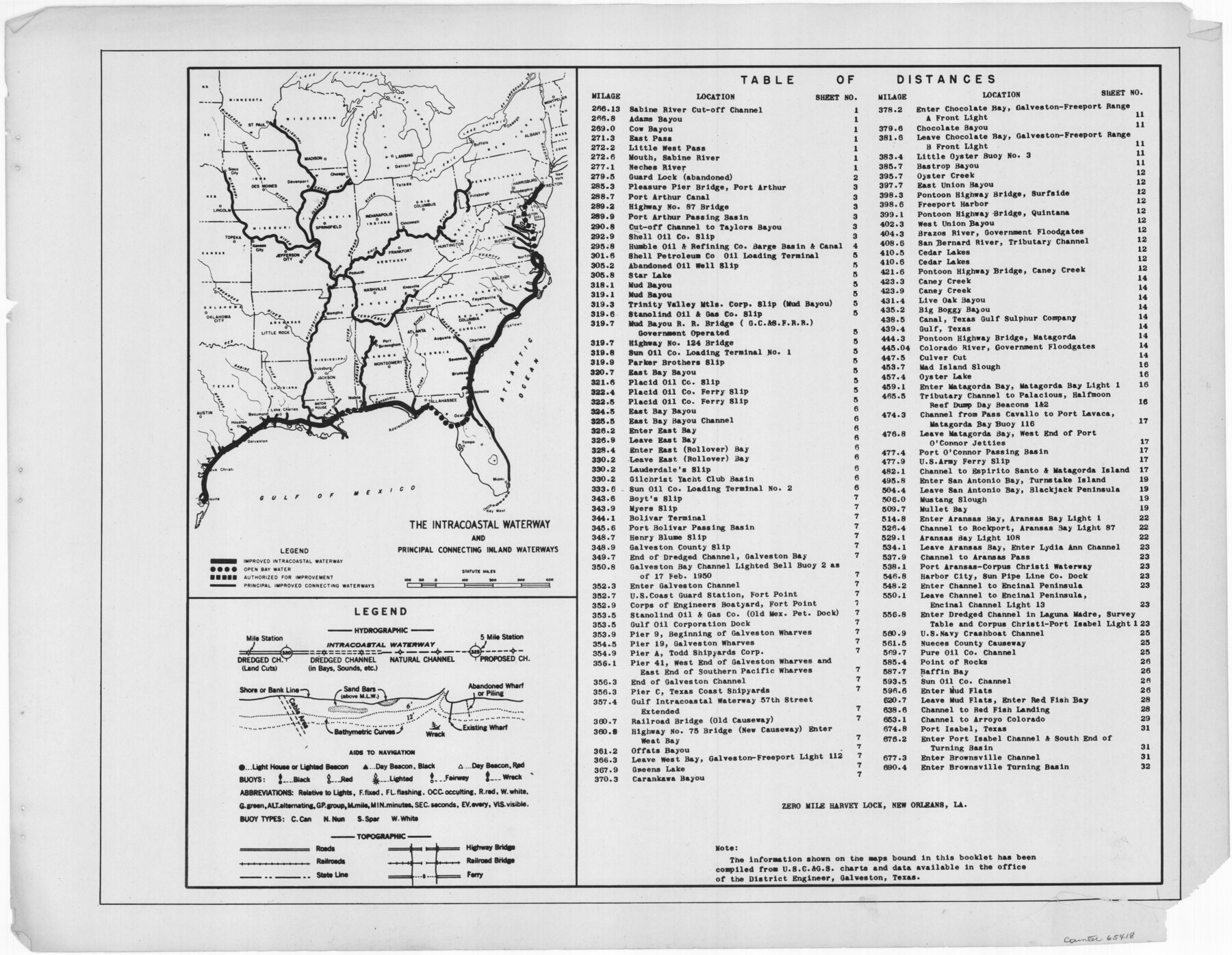
Navigation Maps of Gulf Intracoastal Waterway, Port Arthur to Brownsville, Texas
K-7-68
-
Map/Doc
65418
-
Collection
General Map Collection
-
Object Dates
1951 (Creation Date)
-
People and Organizations
Corps of Engineers (Publisher)
-
Subjects
Intracoastal Waterways
-
Height x Width
16.7 x 21.5 inches
42.4 x 54.6 cm
Part of: General Map Collection
Map of Maryland, Virginia, North Carolina and South Carolina

Print $20.00
- Digital $50.00
Map of Maryland, Virginia, North Carolina and South Carolina
1885
Size 12.2 x 9.0 inches
Map/Doc 93517
Runnels County Rolled Sketch 50

Print $20.00
- Digital $50.00
Runnels County Rolled Sketch 50
Size 31.3 x 26.7 inches
Map/Doc 7535

Bee County Boundary File 5

Print $12.00
- Digital $50.00
Bee County Boundary File 5
Size 9.1 x 9.0 inches
Map/Doc 50452

Rio Grande Rectification Project, El Paso and Juarez Valley

Print $20.00
- Digital $50.00
Rio Grande Rectification Project, El Paso and Juarez Valley
1935
Size 10.8 x 29.6 inches
Map/Doc 60872

Andrews County Rolled Sketch 38

Print $40.00
- Digital $50.00
Andrews County Rolled Sketch 38
1963
Size 38.3 x 50.3 inches
Map/Doc 8400
Wichita County Sketch File 6

Print $40.00
- Digital $50.00
Wichita County Sketch File 6
Size 12.3 x 12.2 inches
Map/Doc 40045
Concho County Rolled Sketch 4

Print $20.00
- Digital $50.00
Concho County Rolled Sketch 4
1948
Size 47.3 x 43.6 inches
Map/Doc 8649
Flight Mission No. BQR-3K, Frame 154, Brazoria County

Print $20.00
- Digital $50.00
Flight Mission No. BQR-3K, Frame 154, Brazoria County
1952
Size 18.7 x 22.3 inches
Map/Doc 83981
Hays County Sketch File 18

Print $4.00
- Digital $50.00
Hays County Sketch File 18
1878
Size 13.0 x 8.1 inches
Map/Doc 26235
You may also like
Flight Mission No. DCL-6C, Frame 5, Kenedy County

Print $20.00
- Digital $50.00
Flight Mission No. DCL-6C, Frame 5, Kenedy County
1943
Size 18.4 x 22.4 inches
Map/Doc 85865
Jones County Boundary File 1

Print $78.00
- Digital $50.00
Jones County Boundary File 1
1882
Size 10.7 x 8.2 inches
Map/Doc 55633
Matagorda County Aerial Photograph Index Sheet 5

Print $20.00
- Digital $50.00
Matagorda County Aerial Photograph Index Sheet 5
1953
Size 23.6 x 19.5 inches
Map/Doc 83726
Jasper County Sketch File 33

Print $20.00
- Digital $50.00
Jasper County Sketch File 33
1938
Size 23.0 x 17.6 inches
Map/Doc 11854

Sutton County Sketch File 56

Print $8.00
Sutton County Sketch File 56
1953
Size 11.2 x 9.0 inches
Map/Doc 37538
2008 Official Travel Map, Texas

2008 Official Travel Map, Texas
Size 33.5 x 36.4 inches
Map/Doc 94344
Duval County Sketch File 5

Print $20.00
- Digital $50.00
Duval County Sketch File 5
1860
Size 20.8 x 29.6 inches
Map/Doc 11381
Williamson County

Print $40.00
- Digital $50.00
Williamson County
1888
Size 39.3 x 57.1 inches
Map/Doc 16929
University Lands, Blocks 34 to 37, Terrell County

Print $20.00
- Digital $50.00
University Lands, Blocks 34 to 37, Terrell County
1938
Size 32.5 x 40.0 inches
Map/Doc 2417
Flight Mission No. DAH-10M, Frame 45, Orange County

Print $20.00
- Digital $50.00
Flight Mission No. DAH-10M, Frame 45, Orange County
1953
Size 18.8 x 22.5 inches
Map/Doc 86880
San Augustine County Working Sketch 13

Print $20.00
- Digital $50.00
San Augustine County Working Sketch 13
1952
Size 34.0 x 27.6 inches
Map/Doc 63701