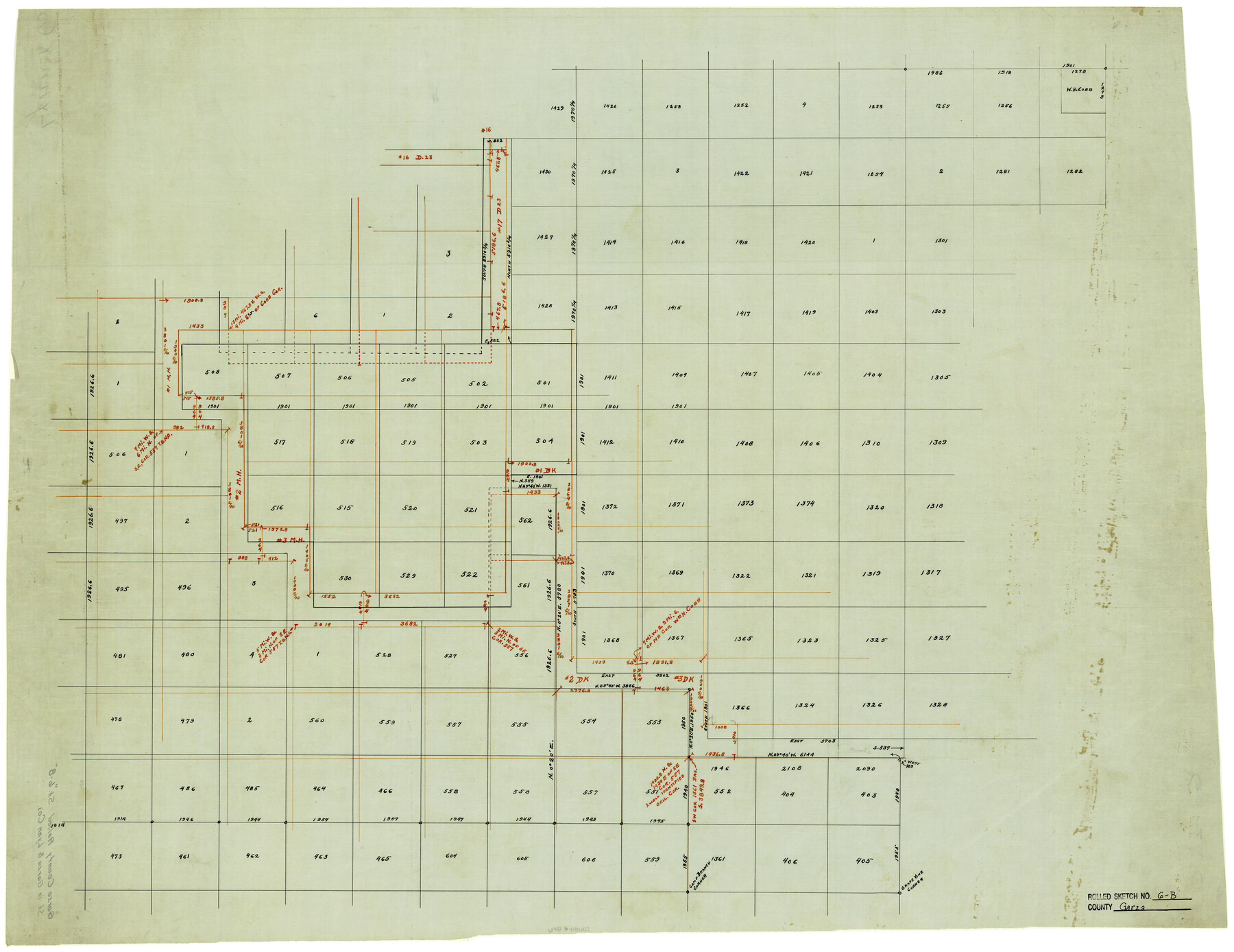
Garza County Rolled Sketch 6B
[Sketch in Garza & Lynn Counties]
-
Map/Doc
5996
-
Collection
General Map Collection
-
Counties
Garza Lynn
-
Subjects
Surveying Rolled Sketch
-
Height x Width
27.6 x 36.4 inches
70.1 x 92.5 cm
-
Medium
linen, manuscript
Part of: General Map Collection
Parker County Rolled Sketch 4

Print $20.00
- Digital $50.00
Parker County Rolled Sketch 4
Size 28.0 x 34.1 inches
Map/Doc 7205
Colorado River, Grape Creek Sheet/Proposed Dam Site

Print $4.00
- Digital $50.00
Colorado River, Grape Creek Sheet/Proposed Dam Site
1937
Size 20.1 x 23.8 inches
Map/Doc 65304
Brewster County Rolled Sketch 59D

Print $20.00
- Digital $50.00
Brewster County Rolled Sketch 59D
Size 33.3 x 47.3 inches
Map/Doc 5231
Galveston County NRC Article 33.136 Location Key Sheet

Print $20.00
- Digital $50.00
Galveston County NRC Article 33.136 Location Key Sheet
1974
Size 27.0 x 23.0 inches
Map/Doc 77025
Flight Mission No. BRA-7M, Frame 79, Jefferson County

Print $20.00
- Digital $50.00
Flight Mission No. BRA-7M, Frame 79, Jefferson County
1953
Size 16.0 x 15.8 inches
Map/Doc 85501
Map of Upshur County

Print $20.00
- Digital $50.00
Map of Upshur County
Size 18.5 x 23.2 inches
Map/Doc 76755
Victoria County Working Sketch 6

Print $20.00
- Digital $50.00
Victoria County Working Sketch 6
1944
Size 36.3 x 33.9 inches
Map/Doc 72276
Wise County Sketch File 26

Print $22.00
- Digital $50.00
Wise County Sketch File 26
1855
Size 8.1 x 14.3 inches
Map/Doc 40574

Wilbarger County Sketch File 1

Print $4.00
- Digital $50.00
Wilbarger County Sketch File 1
Size 8.2 x 12.8 inches
Map/Doc 40162
Fort Bend County Working Sketch 32

Print $20.00
- Digital $50.00
Fort Bend County Working Sketch 32
2000
Size 36.5 x 42.5 inches
Map/Doc 69238

You may also like
Map of Chicago, Rock Island & Texas Railway through Montague and Wise Counties, Texas

Print $40.00
- Digital $50.00
Map of Chicago, Rock Island & Texas Railway through Montague and Wise Counties, Texas
1893
Size 20.2 x 124.5 inches
Map/Doc 64468

![93119, [Capitol Lands], Twichell Survey Records](https://historictexasmaps.com/wmedia_w700/maps/93119-1.tif.jpg)
Texas Takes Shape: A History in Maps from the General Land Office

Price $48.71
Texas Takes Shape: A History in Maps from the General Land Office
Map/Doc 97432
Travis County Appraisal District Plat Map 2_0601

Print $20.00
- Digital $50.00
Travis County Appraisal District Plat Map 2_0601
Size 21.5 x 26.4 inches
Map/Doc 94235
Crockett County Working Sketch 27

Print $20.00
- Digital $50.00
Crockett County Working Sketch 27
1923
Size 29.4 x 27.2 inches
Map/Doc 68360
Lipscomb County, Texas

Print $20.00
- Digital $50.00
Lipscomb County, Texas
Size 13.7 x 15.0 inches
Map/Doc 91304
Parker County Sketch File 9a

Print $4.00
- Digital $50.00
Parker County Sketch File 9a
1859
Size 9.0 x 7.7 inches
Map/Doc 33540
Culberson County Sketch File 11a

Print $4.00
- Digital $50.00
Culberson County Sketch File 11a
1926
Size 14.3 x 8.7 inches
Map/Doc 20172
Eastland County Sketch File 22

Print $33.00
- Digital $50.00
Eastland County Sketch File 22
1964
Size 11.0 x 17.0 inches
Map/Doc 21626
[Atlas D, Table of Contents]
![78350, [Atlas D, Table of Contents], General Map Collection](https://historictexasmaps.com/wmedia_w700/maps/78350.tif.jpg)
Print $20.00
- Digital $50.00
[Atlas D, Table of Contents]
Size 18.3 x 9.5 inches
Map/Doc 78350
Montague County Sketch File 6

Print $4.00
- Digital $50.00
Montague County Sketch File 6
1856
Size 8.0 x 8.4 inches
Map/Doc 31717