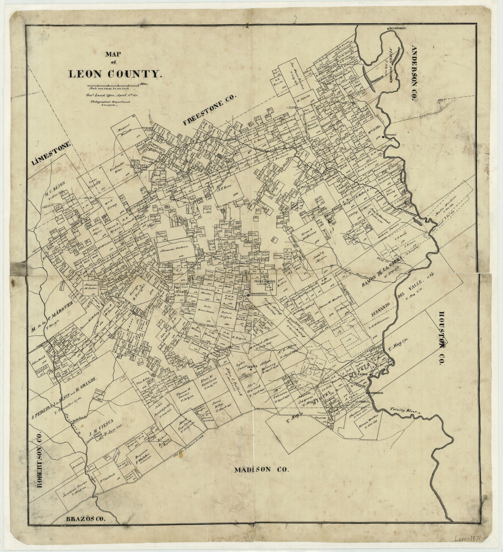
Map of Leon County
-
Map/Doc
4579
-
Collection
General Map Collection
-
Object Dates
1871/4/11 (Creation Date)
-
People and Organizations
Texas General Land Office (Publisher)
Herman Lungkwitz (Draftsman)
-
Counties
Leon
-
Subjects
County
-
Height x Width
25.4 x 23.2 inches
64.5 x 58.9 cm
-
Features
Trinity River
Bone Branch of Buffalo Creek
Lower Keechi Creek
Centerville
Beaver Creek
Brushy Creek
Boggy Creek
Leona
Commerce
Beaverdam Creek
6 Miles Creek
Navasota River
Forky Deer Creek
Caney Creek
Old San Antonio Road
Cairo
Spring Creek
Clover Creek
Birch Creek
Pine Creek
Rasaca Creek
Bliss Branch of Buffalo Creek
Lynn Creek
Lamb's Creek
Aligator [sic] Creek
Silver Creek
Wheelock Creek
Buffalo Creek
Boones Creek
Navarro
Magnolia
Upper Keechi Creek
Irvin Branch [of Upper Keechi Creek]
Part of: General Map Collection
Palo Pinto County Sketch File 21

Print $20.00
- Digital $50.00
Palo Pinto County Sketch File 21
1896
Size 18.5 x 17.5 inches
Map/Doc 12133
Parker County Rolled Sketch 3

Print $20.00
- Digital $50.00
Parker County Rolled Sketch 3
1975
Size 22.7 x 18.3 inches
Map/Doc 7204
Borden - Garza County Line as agreed upon in the 118th Judicial District Court, Howard County, Texas Case No. 13,023

Print $40.00
- Digital $50.00
Borden - Garza County Line as agreed upon in the 118th Judicial District Court, Howard County, Texas Case No. 13,023
1965
Size 19.0 x 102.2 inches
Map/Doc 1697
Dickens County Sketch File E

Print $8.00
- Digital $50.00
Dickens County Sketch File E
Size 11.3 x 8.7 inches
Map/Doc 20843
Potter County Rolled Sketch 8

Print $20.00
- Digital $50.00
Potter County Rolled Sketch 8
1920
Size 26.3 x 30.7 inches
Map/Doc 7321
Atascosa County Rolled Sketch 21

Print $20.00
- Digital $50.00
Atascosa County Rolled Sketch 21
1958
Size 25.0 x 38.0 inches
Map/Doc 5100
Flight Mission No. BRA-8M, Frame 68, Jefferson County

Print $20.00
- Digital $50.00
Flight Mission No. BRA-8M, Frame 68, Jefferson County
1953
Size 18.6 x 22.4 inches
Map/Doc 85588
[Surveys in Robertson's Colony]
![78358, [Surveys in Robertson's Colony], General Map Collection](https://historictexasmaps.com/wmedia_w700/maps/78358.tif.jpg)
Print $20.00
- Digital $50.00
[Surveys in Robertson's Colony]
Size 18.6 x 26.5 inches
Map/Doc 78358
Grimes County Rolled Sketch 2

Print $20.00
- Digital $50.00
Grimes County Rolled Sketch 2
Size 29.2 x 24.3 inches
Map/Doc 6043
Presidio County Working Sketch 83

Print $20.00
- Digital $50.00
Presidio County Working Sketch 83
1969
Size 21.5 x 24.8 inches
Map/Doc 71760
Bowie County Working Sketch 12

Print $20.00
- Digital $50.00
Bowie County Working Sketch 12
1959
Size 31.3 x 23.3 inches
Map/Doc 67416
Culberson County Sketch File 26

Print $8.00
- Digital $50.00
Culberson County Sketch File 26
1949
Size 11.2 x 8.8 inches
Map/Doc 20262
You may also like
Jefferson County Rolled Sketch 2

Print $20.00
- Digital $50.00
Jefferson County Rolled Sketch 2
1904
Size 33.1 x 44.7 inches
Map/Doc 6383
Kent County Boundary File 10

Print $16.00
- Digital $50.00
Kent County Boundary File 10
Size 14.0 x 8.8 inches
Map/Doc 55887
[Blocks M18, M23, I, Z, and Block 47, Sections 16 - 28]
![91175, [Blocks M18, M23, I, Z, and Block 47, Sections 16 - 28], Twichell Survey Records](https://historictexasmaps.com/wmedia_w700/maps/91175-1.tif.jpg)
Print $20.00
- Digital $50.00
[Blocks M18, M23, I, Z, and Block 47, Sections 16 - 28]
Size 18.9 x 24.3 inches
Map/Doc 91175
El Paso County Working Sketch 6

Print $20.00
- Digital $50.00
El Paso County Working Sketch 6
1928
Size 25.4 x 16.7 inches
Map/Doc 69028
Gulf Intracoastal Waterway, Tex. - Aransas Bay to Corpus Christi Bay - Modified Route of Main Channel/Dredging

Print $20.00
- Digital $50.00
Gulf Intracoastal Waterway, Tex. - Aransas Bay to Corpus Christi Bay - Modified Route of Main Channel/Dredging
1958
Size 31.3 x 42.8 inches
Map/Doc 61899
Bee County Working Sketch 23

Print $20.00
- Digital $50.00
Bee County Working Sketch 23
1985
Size 32.6 x 31.1 inches
Map/Doc 67273
McLennan County Boundary File 1

Print $80.00
- Digital $50.00
McLennan County Boundary File 1
Size 19.4 x 12.3 inches
Map/Doc 56937

[Sketch showing PSL Blocks A13, A25-A27, A30-A32, A37, A38, A47-A49 & N/L Univ. Blk. 11]
![89738, [Sketch showing PSL Blocks A13, A25-A27, A30-A32, A37, A38, A47-A49 & N/L Univ. Blk. 11], Twichell Survey Records](https://historictexasmaps.com/wmedia_w700/maps/89738-1.tif.jpg)
Print $40.00
- Digital $50.00
[Sketch showing PSL Blocks A13, A25-A27, A30-A32, A37, A38, A47-A49 & N/L Univ. Blk. 11]
Size 23.6 x 62.4 inches
Map/Doc 89738
Stephens County Working Sketch 16

Print $20.00
- Digital $50.00
Stephens County Working Sketch 16
1968
Size 21.4 x 30.4 inches
Map/Doc 63959
Flight Mission No. DQO-8K, Frame 46, Galveston County

Print $20.00
- Digital $50.00
Flight Mission No. DQO-8K, Frame 46, Galveston County
1952
Size 18.7 x 22.4 inches
Map/Doc 85153
Flight Mission No. CLL-3N, Frame 11, Willacy County

Print $20.00
- Digital $50.00
Flight Mission No. CLL-3N, Frame 11, Willacy County
1954
Size 18.6 x 22.3 inches
Map/Doc 87077