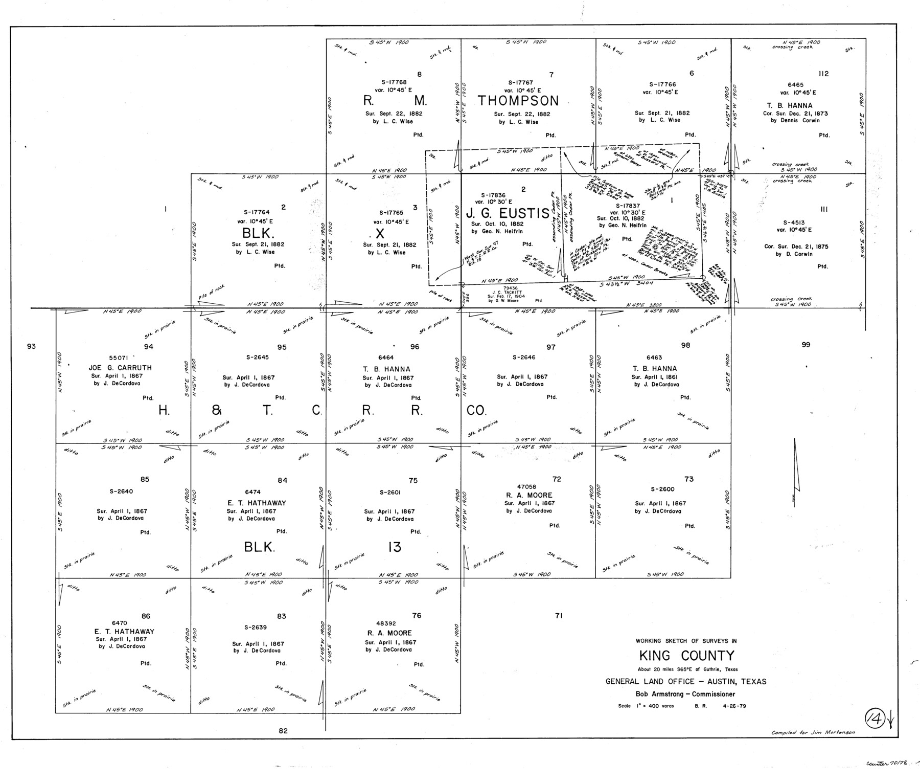
King County Working Sketch 14
-
Map/Doc
70178
-
Collection
General Map Collection
-
Object Dates
4/26/1979 (Creation Date)
-
People and Organizations
Beverly Robison (Draftsman)
-
Counties
King
-
Subjects
Surveying Working Sketch
-
Height x Width
27.7 x 32.5 inches
70.4 x 82.6 cm
-
Scale
1" = 400 varas
Part of: General Map Collection
Hunt County Sketch File 34

Print $6.00
- Digital $50.00
Hunt County Sketch File 34
Size 9.9 x 7.2 inches
Map/Doc 27143
Gillespie County Sketch File 13

Print $4.00
- Digital $50.00
Gillespie County Sketch File 13
1878
Size 8.4 x 10.9 inches
Map/Doc 24153
Flight Mission No. DQN-1K, Frame 152, Calhoun County

Print $20.00
- Digital $50.00
Flight Mission No. DQN-1K, Frame 152, Calhoun County
1953
Size 18.6 x 22.3 inches
Map/Doc 84211
Lavaca County Working Sketch 24

Print $20.00
- Digital $50.00
Lavaca County Working Sketch 24
1985
Size 29.5 x 35.7 inches
Map/Doc 70377
Hardin County Sketch File 61

Print $20.00
- Digital $50.00
Hardin County Sketch File 61
1933
Size 18.9 x 24.6 inches
Map/Doc 11636
Flight Mission No. CRK-8P, Frame 123, Refugio County

Print $20.00
- Digital $50.00
Flight Mission No. CRK-8P, Frame 123, Refugio County
1956
Size 18.4 x 22.1 inches
Map/Doc 86978
Controlled Mosaic by Jack Amman Photogrammetric Engineers, Inc - Sheet 45

Print $20.00
- Digital $50.00
Controlled Mosaic by Jack Amman Photogrammetric Engineers, Inc - Sheet 45
1954
Size 20.0 x 24.0 inches
Map/Doc 83504
In the Supreme Court of the United States, The State of Oklahoma, Complainant vs. The State of Texas, Defendant, The United States of America, Intervener, Red River Valley, Texas and Oklahoma Between the 98th and 100th Meridians in Five Sheets, 1921

Print $40.00
- Digital $50.00
In the Supreme Court of the United States, The State of Oklahoma, Complainant vs. The State of Texas, Defendant, The United States of America, Intervener, Red River Valley, Texas and Oklahoma Between the 98th and 100th Meridians in Five Sheets, 1921
1921
Size 38.4 x 60.0 inches
Map/Doc 75275
Angelina County Sketch File 27

Print $10.00
- Digital $50.00
Angelina County Sketch File 27
1890
Size 14.1 x 8.7 inches
Map/Doc 13073
San Saba County Working Sketch 1

Print $20.00
- Digital $50.00
San Saba County Working Sketch 1
1919
Size 15.3 x 15.3 inches
Map/Doc 63789
Flight Mission No. DAG-21K, Frame 101, Matagorda County

Print $20.00
- Digital $50.00
Flight Mission No. DAG-21K, Frame 101, Matagorda County
1952
Size 18.6 x 22.4 inches
Map/Doc 86430
Flight Mission No. DCL-4C, Frame 64, Kenedy County

Print $20.00
- Digital $50.00
Flight Mission No. DCL-4C, Frame 64, Kenedy County
1943
Size 18.6 x 22.4 inches
Map/Doc 85809
You may also like
North Part Brewster Co.

Print $20.00
- Digital $50.00
North Part Brewster Co.
1914
Size 38.7 x 47.8 inches
Map/Doc 16948
Illinois, Missouri, Iowa, Wisconsin and Minnesota

Print $20.00
- Digital $50.00
Illinois, Missouri, Iowa, Wisconsin and Minnesota
1885
Size 12.2 x 9.0 inches
Map/Doc 93521
Lampasas County Rolled Sketch 2

Print $20.00
- Digital $50.00
Lampasas County Rolled Sketch 2
Size 21.0 x 39.2 inches
Map/Doc 6565
From Citizens of Shelby County for the Creation of a New County to be Called Caddo, April 7, 1838

Print $20.00
From Citizens of Shelby County for the Creation of a New County to be Called Caddo, April 7, 1838
2020
Size 25.5 x 21.7 inches
Map/Doc 96377
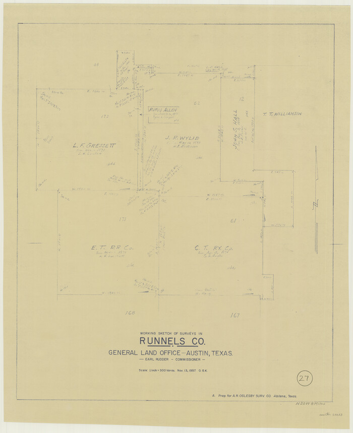
Runnels County Working Sketch 27
Print $20.00
- Digital $50.00
Runnels County Working Sketch 27
1957
Size 27.1 x 22.1 inches
Map/Doc 63623
Denton County Texas

Print $20.00
- Digital $50.00
Denton County Texas
1896
Size 18.4 x 31.6 inches
Map/Doc 4530
Nueces County Sketch File 66

Print $18.00
- Digital $50.00
Nueces County Sketch File 66
1981
Size 14.3 x 8.8 inches
Map/Doc 32989
Sutton County Sketch File 2

Print $4.00
- Digital $50.00
Sutton County Sketch File 2
1898
Size 6.1 x 9.7 inches
Map/Doc 37351
The Mexican Municipality of Austin. Proposed, No Date

Print $20.00
The Mexican Municipality of Austin. Proposed, No Date
2020
Size 17.0 x 21.7 inches
Map/Doc 96014

Anderson County Working Sketch 19

Print $20.00
- Digital $50.00
Anderson County Working Sketch 19
1951
Size 15.5 x 29.2 inches
Map/Doc 67019
Refugio County, Texas

Print $20.00
- Digital $50.00
Refugio County, Texas
1879
Size 19.9 x 29.0 inches
Map/Doc 600