Morris County Rolled Sketch 2A
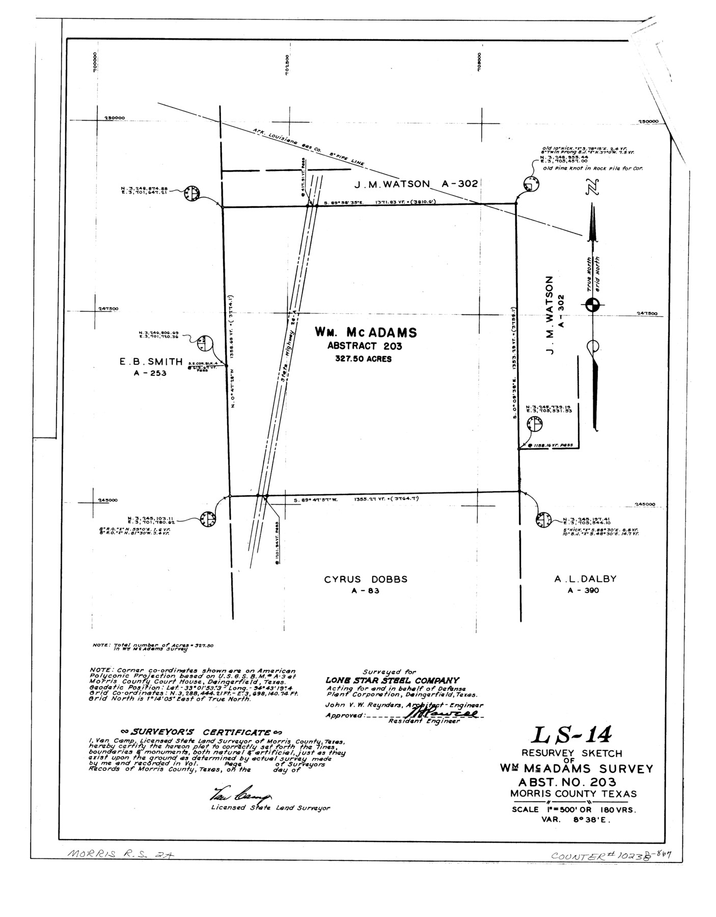
LS-14 - Resurvey sketch of Wm. McAdams survey, abst. no. 203, Morris County, Texas
-
Map/Doc
10238
-
Collection
General Map Collection
-
People and Organizations
Van Camp (Surveyor/Engineer)
-
Counties
Morris
-
Subjects
Surveying Rolled Sketch
-
Height x Width
24.0 x 18.8 inches
61.0 x 47.8 cm
-
Medium
linen, manuscript
-
Scale
1" = 180 varas
-
Comments
See Morris County Rolled Sketch 2 (9550) for map of all retracement surveys made for Lone Star Steel Company.
Related maps
Morris County Rolled Sketch 2

Print $40.00
- Digital $50.00
Morris County Rolled Sketch 2
1944
Size 59.4 x 43.5 inches
Map/Doc 9550
Part of: General Map Collection
Map of Archer County

Print $20.00
- Digital $50.00
Map of Archer County
1886
Size 24.4 x 20.5 inches
Map/Doc 3240
Concho County Working Sketch 12

Print $20.00
- Digital $50.00
Concho County Working Sketch 12
1951
Size 23.0 x 27.2 inches
Map/Doc 68194
Lee County Working Sketch 7

Print $20.00
- Digital $50.00
Lee County Working Sketch 7
1977
Size 27.0 x 16.8 inches
Map/Doc 70386
Jefferson County Sketch file 30

Print $22.00
- Digital $50.00
Jefferson County Sketch file 30
1917
Size 11.2 x 8.8 inches
Map/Doc 28194
Jackson County Sketch File 10x

Print $40.00
- Digital $50.00
Jackson County Sketch File 10x
1914
Size 13.8 x 12.0 inches
Map/Doc 27656
Flight Mission No. BQR-9K, Frame 9, Brazoria County

Print $20.00
- Digital $50.00
Flight Mission No. BQR-9K, Frame 9, Brazoria County
1952
Size 18.6 x 22.3 inches
Map/Doc 84038
Texas, San Antonio Bay, Guadalupe Bay

Print $40.00
- Digital $50.00
Texas, San Antonio Bay, Guadalupe Bay
1934
Size 28.8 x 48.4 inches
Map/Doc 69999
Sutton County Working Sketch 15

Print $40.00
- Digital $50.00
Sutton County Working Sketch 15
1972
Size 37.0 x 81.1 inches
Map/Doc 62358
Flight Mission No. DQO-3K, Frame 39, Galveston County

Print $20.00
- Digital $50.00
Flight Mission No. DQO-3K, Frame 39, Galveston County
1952
Size 18.8 x 22.5 inches
Map/Doc 85080
Erath County Working Sketch 31

Print $20.00
- Digital $50.00
Erath County Working Sketch 31
1970
Size 23.2 x 26.2 inches
Map/Doc 69112
Shelby County Rolled Sketch 9

Print $20.00
- Digital $50.00
Shelby County Rolled Sketch 9
Size 23.0 x 19.1 inches
Map/Doc 7777
Edwards County Sketch File 16b

Print $56.00
- Digital $50.00
Edwards County Sketch File 16b
1907
Size 9.4 x 8.7 inches
Map/Doc 21722
You may also like
Newton County Working Sketch 12

Print $20.00
- Digital $50.00
Newton County Working Sketch 12
1942
Size 24.5 x 28.5 inches
Map/Doc 71258
Floyd County Sketch File 24

Print $6.00
- Digital $50.00
Floyd County Sketch File 24
1915
Size 9.0 x 14.5 inches
Map/Doc 22780
New Hobbs, Lea County, New Mexico

Print $20.00
- Digital $50.00
New Hobbs, Lea County, New Mexico
Size 15.7 x 20.1 inches
Map/Doc 92424
Victoria County Working Sketch 1

Print $20.00
- Digital $50.00
Victoria County Working Sketch 1
1938
Size 33.5 x 36.9 inches
Map/Doc 72271
Comanche County Working Sketch 16

Print $20.00
- Digital $50.00
Comanche County Working Sketch 16
1969
Size 16.5 x 23.8 inches
Map/Doc 68150
Erath County Rolled Sketch 3A

Print $20.00
- Digital $50.00
Erath County Rolled Sketch 3A
1982
Size 21.7 x 27.8 inches
Map/Doc 5865
United States Bathymetric and Fishing Maps including Topographic/Bathymetric Maps

Print $40.00
- Digital $50.00
United States Bathymetric and Fishing Maps including Topographic/Bathymetric Maps
1989
Size 20.4 x 54.4 inches
Map/Doc 73557
Real County Working Sketch 28

Print $20.00
- Digital $50.00
Real County Working Sketch 28
1947
Size 15.7 x 28.3 inches
Map/Doc 71920
Leveland and Adjacent Subdivisions of League 28, Hood County School Land Hockley County, Texas

Print $40.00
- Digital $50.00
Leveland and Adjacent Subdivisions of League 28, Hood County School Land Hockley County, Texas
Size 42.4 x 50.4 inches
Map/Doc 89848
Dickens County Sketch File 2b

Print $14.00
- Digital $50.00
Dickens County Sketch File 2b
Size 8.8 x 13.4 inches
Map/Doc 20952
Val Verde County Sketch File 47

Print $20.00
- Digital $50.00
Val Verde County Sketch File 47
1951
Size 25.1 x 18.7 inches
Map/Doc 12588
Ward County Rolled Sketch 7

Print $40.00
- Digital $50.00
Ward County Rolled Sketch 7
1907
Size 33.9 x 91.0 inches
Map/Doc 10103