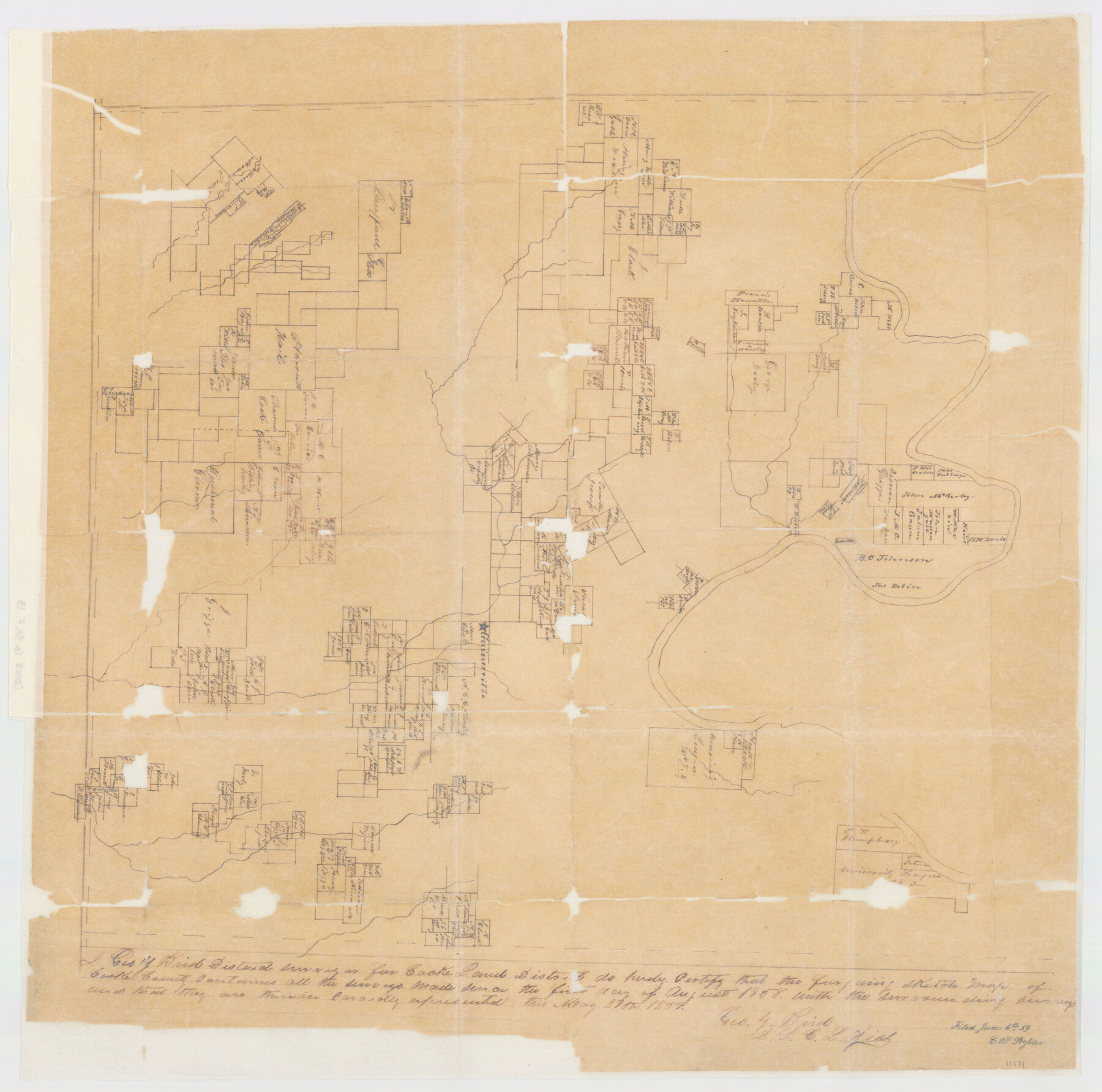
Cooke County Sketch File 13
[Sketch of surveys made in Cooke County since August 1, 1858]
-
Map/Doc
11171
-
Collection
General Map Collection
-
Object Dates
5/27/1859 (Creation Date)
6/6/1859 (File Date)
-
People and Organizations
Geo. Y. Bird (Surveyor/Engineer)
-
Counties
Cooke
-
Subjects
Surveying Sketch File
-
Height x Width
27.1 x 19.0 inches
68.8 x 48.3 cm
-
Medium
paper, manuscript
-
Features
Gainesville
Part of: General Map Collection
1910 Map of the City of Houston and vicinity

Print $20.00
- Digital $50.00
1910 Map of the City of Houston and vicinity
1910
Size 20.5 x 23.4 inches
Map/Doc 97452

Stephens County Sketch File 7

Print $4.00
- Digital $50.00
Stephens County Sketch File 7
1875
Size 8.1 x 9.9 inches
Map/Doc 37025
Grayson County Sketch File 14

Print $23.00
- Digital $50.00
Grayson County Sketch File 14
1873
Size 14.0 x 12.0 inches
Map/Doc 24482
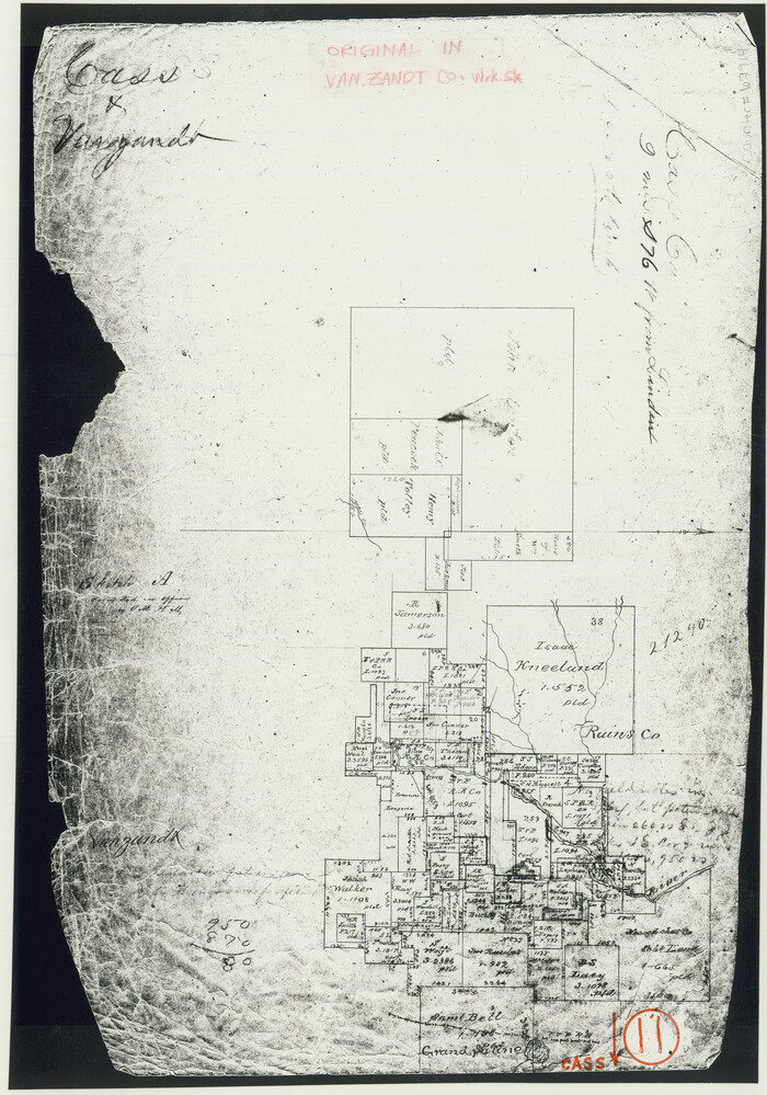
Cass County Working Sketch 11
Print $3.00
- Digital $50.00
Cass County Working Sketch 11
Size 14.8 x 10.3 inches
Map/Doc 67914
Flight Mission No. DAG-21K, Frame 101, Matagorda County

Print $20.00
- Digital $50.00
Flight Mission No. DAG-21K, Frame 101, Matagorda County
1952
Size 18.6 x 22.4 inches
Map/Doc 86430
Houston County Sketch File 39

Print $6.00
- Digital $50.00
Houston County Sketch File 39
1845
Size 17.0 x 10.9 inches
Map/Doc 26824
No. 3 Chart of Channel connecting Corpus Christi Bay with Aransas Bay, Texas

Print $20.00
- Digital $50.00
No. 3 Chart of Channel connecting Corpus Christi Bay with Aransas Bay, Texas
1878
Size 18.3 x 28.0 inches
Map/Doc 72773
King County Boundary File 6

Print $16.00
- Digital $50.00
King County Boundary File 6
Size 9.2 x 6.6 inches
Map/Doc 64927
Flight Mission No. DQN-1K, Frame 44, Calhoun County

Print $20.00
- Digital $50.00
Flight Mission No. DQN-1K, Frame 44, Calhoun County
1953
Size 18.6 x 22.3 inches
Map/Doc 84144
Kinney County Working Sketch 42

Print $20.00
- Digital $50.00
Kinney County Working Sketch 42
1973
Size 20.4 x 33.7 inches
Map/Doc 70224
Sketch showing Mineral Leases in Nueces Bay

Print $20.00
- Digital $50.00
Sketch showing Mineral Leases in Nueces Bay
1942
Size 14.3 x 24.3 inches
Map/Doc 3019
You may also like
Denton County Sketch File 42

Print $4.00
- Digital $50.00
Denton County Sketch File 42
1960
Size 11.4 x 8.9 inches
Map/Doc 20792
[Surveys near Brushy Creek]
![360, [Surveys near Brushy Creek], General Map Collection](https://historictexasmaps.com/wmedia_w700/maps/360.tif.jpg)
Print $2.00
- Digital $50.00
[Surveys near Brushy Creek]
1845
Size 10.0 x 7.9 inches
Map/Doc 360
Liberty County Rolled Sketch 14

Print $20.00
- Digital $50.00
Liberty County Rolled Sketch 14
Size 33.2 x 43.9 inches
Map/Doc 6620
Jeff Davis County Sketch File 44

Print $8.00
- Digital $50.00
Jeff Davis County Sketch File 44
1886
Size 8.5 x 8.0 inches
Map/Doc 28071
Duval County Working Sketch 52

Print $20.00
- Digital $50.00
Duval County Working Sketch 52
1942
Size 22.1 x 25.9 inches
Map/Doc 68776
Uvalde County Working Sketch 3

Print $20.00
- Digital $50.00
Uvalde County Working Sketch 3
1915
Size 37.9 x 34.1 inches
Map/Doc 72073
Real County Working Sketch 67

Print $20.00
- Digital $50.00
Real County Working Sketch 67
1970
Size 21.2 x 16.4 inches
Map/Doc 71959
Rueben M. Ellerd 17,870 acres of land in Bailey and Cochran Cos., Texas

Print $20.00
- Digital $50.00
Rueben M. Ellerd 17,870 acres of land in Bailey and Cochran Cos., Texas
1906
Size 22.4 x 30.0 inches
Map/Doc 90242
Bosque County Working Sketch 31

Print $20.00
- Digital $50.00
Bosque County Working Sketch 31
2010
Size 29.8 x 34.6 inches
Map/Doc 89277
Hutchinson County Rolled Sketch 40

Print $20.00
- Digital $50.00
Hutchinson County Rolled Sketch 40
1981
Size 25.7 x 37.3 inches
Map/Doc 6304
[Santa Rosa Leagues, Brooks & Kenedy Counties, Texas]
![10774, [Santa Rosa Leagues, Brooks & Kenedy Counties, Texas], Maddox Collection](https://historictexasmaps.com/wmedia_w700/maps/10774.tif.jpg)
Print $20.00
- Digital $50.00
[Santa Rosa Leagues, Brooks & Kenedy Counties, Texas]
Size 21.0 x 24.6 inches
Map/Doc 10774
Dimmit County Working Sketch 13

Print $20.00
- Digital $50.00
Dimmit County Working Sketch 13
1941
Size 14.3 x 16.3 inches
Map/Doc 68674