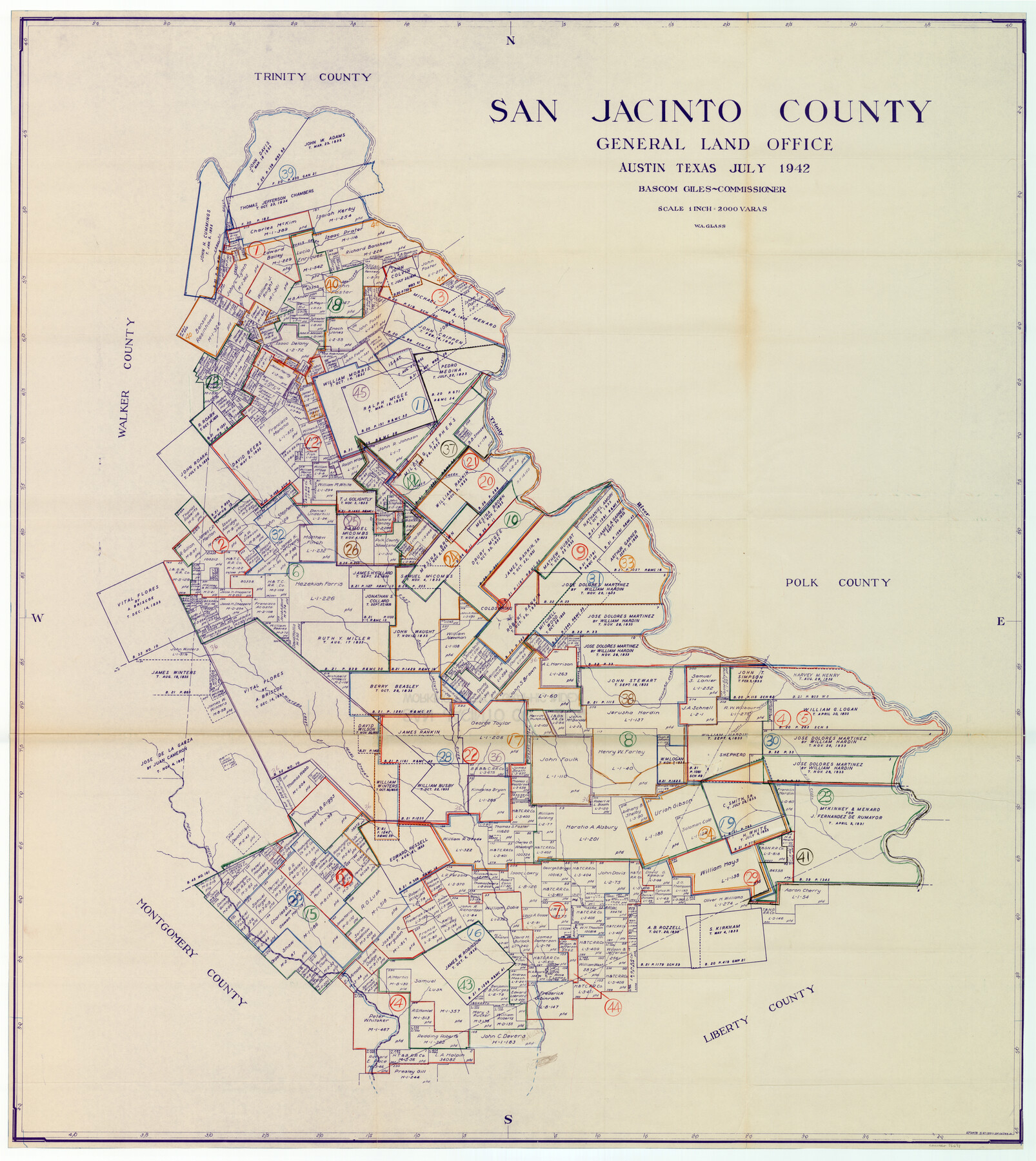
San Jacinto County Working Sketch Graphic Index
-
Map/Doc
76691
-
Collection
General Map Collection
-
Object Dates
7/1942 (Creation Date)
-
People and Organizations
W.A. Glass (Draftsman)
-
Counties
San Jacinto
-
Subjects
County Surveying Working Sketch
-
Height x Width
44.9 x 40.6 inches
114.1 x 103.1 cm
-
Scale
1" = 2000 varas
Part of: General Map Collection
Dickens County Sketch File J

Print $12.00
- Digital $50.00
Dickens County Sketch File J
1904
Size 11.6 x 9.1 inches
Map/Doc 20883
Carte d'un Nouveau Monde, entre le Nouveau Mexique, et la Mer Glacialle

Print $20.00
- Digital $50.00
Carte d'un Nouveau Monde, entre le Nouveau Mexique, et la Mer Glacialle
1698
Size 11.5 x 18.1 inches
Map/Doc 96555
Map of Comanche Co.

Print $20.00
- Digital $50.00
Map of Comanche Co.
1896
Size 41.5 x 44.9 inches
Map/Doc 4918
Ward County Working Sketch 21

Print $20.00
- Digital $50.00
Ward County Working Sketch 21
1953
Size 20.9 x 14.7 inches
Map/Doc 72327
Flight Mission No. DAG-17K, Frame 124, Matagorda County

Print $20.00
- Digital $50.00
Flight Mission No. DAG-17K, Frame 124, Matagorda County
1952
Size 18.6 x 22.3 inches
Map/Doc 86344
Val Verde County Working Sketch 117

Print $20.00
- Digital $50.00
Val Verde County Working Sketch 117
1993
Size 30.9 x 37.0 inches
Map/Doc 82844
Chocolate Bay, West Portion of West Bay and Vicinity, and Galveston Cos. Showing Subdivision for Mineral Development.

Print $40.00
- Digital $50.00
Chocolate Bay, West Portion of West Bay and Vicinity, and Galveston Cos. Showing Subdivision for Mineral Development.
1948
Size 43.0 x 55.9 inches
Map/Doc 3012
Medina County Working Sketch 14

Print $20.00
- Digital $50.00
Medina County Working Sketch 14
1972
Size 21.5 x 30.7 inches
Map/Doc 70929
Flight Mission No. DQN-7K, Frame 89, Calhoun County

Print $20.00
- Digital $50.00
Flight Mission No. DQN-7K, Frame 89, Calhoun County
1953
Size 18.4 x 22.2 inches
Map/Doc 84480
Lamar County State Real Property Sketch 1

Print $20.00
- Digital $50.00
Lamar County State Real Property Sketch 1
2013
Size 24.0 x 36.0 inches
Map/Doc 93659

Edwards County Working Sketch 3

Print $20.00
- Digital $50.00
Edwards County Working Sketch 3
Size 22.6 x 18.3 inches
Map/Doc 68879
You may also like
Hutchinson County Rolled Sketch 27

Print $53.00
- Digital $50.00
Hutchinson County Rolled Sketch 27
1920
Size 33.3 x 27.1 inches
Map/Doc 6289
Tyler County Working Sketch 4

Print $20.00
- Digital $50.00
Tyler County Working Sketch 4
1926
Size 19.4 x 35.8 inches
Map/Doc 69474
Somervell County Working Sketch 2

Print $20.00
- Digital $50.00
Somervell County Working Sketch 2
1951
Size 22.4 x 23.8 inches
Map/Doc 63906
Tracing "A" [showing Rio Grande and settlements along river]
![72888, Tracing "A" [showing Rio Grande and settlements along river], General Map Collection](https://historictexasmaps.com/wmedia_w700/maps/72888.tif.jpg)
Print $20.00
- Digital $50.00
Tracing "A" [showing Rio Grande and settlements along river]
1881
Size 18.2 x 25.9 inches
Map/Doc 72888
Map of Asia engraved to illustrate Mitchell's school and family geography (Inset: Map of Palestine or the Holy Land)

Print $20.00
- Digital $50.00
Map of Asia engraved to illustrate Mitchell's school and family geography (Inset: Map of Palestine or the Holy Land)
1839
Size 9.5 x 11.8 inches
Map/Doc 93506
Pecos County Working Sketch Graphic Index - northwest part - sheet B

Print $20.00
- Digital $50.00
Pecos County Working Sketch Graphic Index - northwest part - sheet B
1975
Size 42.1 x 42.6 inches
Map/Doc 76664
Kleberg County Rolled Sketch 10-28

Print $20.00
- Digital $50.00
Kleberg County Rolled Sketch 10-28
1952
Size 36.2 x 33.9 inches
Map/Doc 9375
Comanche County Working Sketch 11

Print $20.00
- Digital $50.00
Comanche County Working Sketch 11
1955
Size 31.7 x 43.3 inches
Map/Doc 68145
Gray County Sketch File 1

Print $4.00
- Digital $50.00
Gray County Sketch File 1
1882
Size 10.4 x 7.2 inches
Map/Doc 24396
General Highway Map, Bee County, Texas

Print $20.00
General Highway Map, Bee County, Texas
1940
Size 25.0 x 18.4 inches
Map/Doc 79014

Nueces County NRC Article 33.136 Sketch 18

Print $74.00
- Digital $50.00
Nueces County NRC Article 33.136 Sketch 18
2014
Size 22.0 x 34.0 inches
Map/Doc 94714