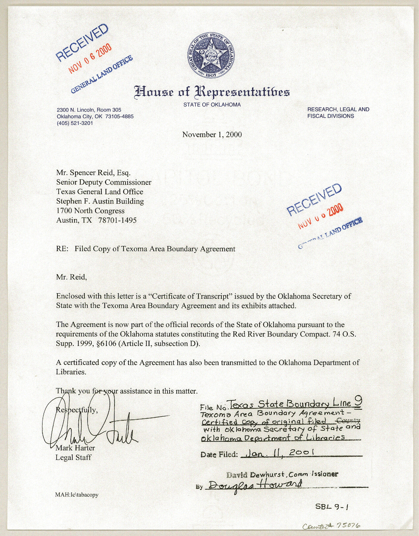
Texas State Boundary Line 9
Texoma Area Boundary Agreement, certified copy of original filed with Oklahoma Secretary of State and Oklahoma Department of Libraries with accompanying USGS topo sheets
-
Map/Doc
75076
-
Collection
General Map Collection
-
Object Dates
2000/10/24 (Creation Date)
-
Subjects
Texas Boundaries
-
Height x Width
11.3 x 8.8 inches
28.7 x 22.4 cm
-
Comments
See maps 97360-97366 for USGS Topo Quadrangles showing the plotted Texoma Area Boundary.
Related maps
Texas State Boundary Line 7

Print $182.00
Texas State Boundary Line 7
2000
Size 11.2 x 8.8 inches
Map/Doc 75018
Texas State Boundary Line 8

Print $170.00
Texas State Boundary Line 8
2000
Size 11.3 x 8.8 inches
Map/Doc 75054
Lebanon Quadrangle

Print $20.00
- Digital $50.00
Lebanon Quadrangle
1999
Size 35.4 x 23.4 inches
Map/Doc 97360
Dexter Quadrangle

Print $20.00
- Digital $50.00
Dexter Quadrangle
1999
Size 35.4 x 23.4 inches
Map/Doc 97361
Gordonville Quadrangle

Print $20.00
- Digital $50.00
Gordonville Quadrangle
1999
Size 35.4 x 23.4 inches
Map/Doc 97362
Pottsboro Quadrangle

Print $20.00
- Digital $50.00
Pottsboro Quadrangle
1999
Size 35.4 x 23.4 inches
Map/Doc 97363
Kingston South Quadrangle

Print $20.00
- Digital $50.00
Kingston South Quadrangle
1999
Size 35.4 x 23.4 inches
Map/Doc 97364
Platter Quadrangle

Print $20.00
- Digital $50.00
Platter Quadrangle
1999
Size 35.4 x 23.4 inches
Map/Doc 97365
Denison Dam Quadrangle

Print $20.00
- Digital $50.00
Denison Dam Quadrangle
1999
Size 35.4 x 23.4 inches
Map/Doc 97366

Part of: General Map Collection
The University of Texas at Austin

The University of Texas at Austin
Size 16.0 x 17.1 inches
Map/Doc 94388
Dallam County

Print $40.00
- Digital $50.00
Dallam County
1901
Size 44.3 x 56.3 inches
Map/Doc 93459
State University and PSL Blocks 1 through 77 in Andrews, Culberson, Crane, Ector, El Paso, Gaines, Loving, Martin, Reeves, Tom Green, Ward County, and Winkler Counties

State University and PSL Blocks 1 through 77 in Andrews, Culberson, Crane, Ector, El Paso, Gaines, Loving, Martin, Reeves, Tom Green, Ward County, and Winkler Counties
Map/Doc 81652
Fractional Township No. 7 South Range No. 7 West of the Indian Meridian, Indian Territory

Print $20.00
- Digital $50.00
Fractional Township No. 7 South Range No. 7 West of the Indian Meridian, Indian Territory
1898
Size 19.2 x 24.4 inches
Map/Doc 75168
Webb County Sketch File 9

Print $25.00
- Digital $50.00
Webb County Sketch File 9
1870
Size 9.5 x 8.5 inches
Map/Doc 39761

Map of Pecos and Reeves Counties

Print $40.00
- Digital $50.00
Map of Pecos and Reeves Counties
1873
Size 45.3 x 115.6 inches
Map/Doc 75930
Baylor County Sketch File 11A

Print $40.00
- Digital $50.00
Baylor County Sketch File 11A
Size 33.9 x 32.0 inches
Map/Doc 10322
[Sketch for Mineral Application 27669 - Trinity River, Frank R. Graves]
![2860, [Sketch for Mineral Application 27669 - Trinity River, Frank R. Graves], General Map Collection](https://historictexasmaps.com/wmedia_w700/maps/2860-1.tif.jpg)
Print $20.00
- Digital $50.00
[Sketch for Mineral Application 27669 - Trinity River, Frank R. Graves]
1934
Size 27.4 x 42.7 inches
Map/Doc 2860
Loving County

Print $20.00
- Digital $50.00
Loving County
1932
Size 32.4 x 44.0 inches
Map/Doc 77358
San Patricio County Sketch File 18

Print $4.00
San Patricio County Sketch File 18
Size 6.2 x 8.3 inches
Map/Doc 36066

You may also like
Webb County Sketch File 6

Print $5.00
- Digital $50.00
Webb County Sketch File 6
1875
Size 7.3 x 13.7 inches
Map/Doc 39735

Menard County Working Sketch 1

Print $20.00
- Digital $50.00
Menard County Working Sketch 1
1905
Size 23.3 x 18.9 inches
Map/Doc 70948
Amistad International Reservoir on Rio Grande 111

Print $20.00
- Digital $50.00
Amistad International Reservoir on Rio Grande 111
1950
Size 28.5 x 41.0 inches
Map/Doc 75542
La Salle County Sketch File 46

Print $20.00
- Digital $50.00
La Salle County Sketch File 46
Size 14.1 x 8.6 inches
Map/Doc 29603
Fayette County Working Sketch Graphic Index

Print $40.00
- Digital $50.00
Fayette County Working Sketch Graphic Index
1978
Size 42.9 x 54.7 inches
Map/Doc 76541

Hudspeth County Working Sketch 31

Print $40.00
- Digital $50.00
Hudspeth County Working Sketch 31
1972
Size 56.2 x 41.2 inches
Map/Doc 66314

Zavala County Sketch File 11

Print $4.00
- Digital $50.00
Zavala County Sketch File 11
1885
Size 14.4 x 8.8 inches
Map/Doc 41270
Culberson County Working Sketch 16

Print $20.00
- Digital $50.00
Culberson County Working Sketch 16
1926
Size 17.5 x 23.4 inches
Map/Doc 68468
McLennan County

Print $20.00
- Digital $50.00
McLennan County
1946
Size 42.5 x 45.8 inches
Map/Doc 73235