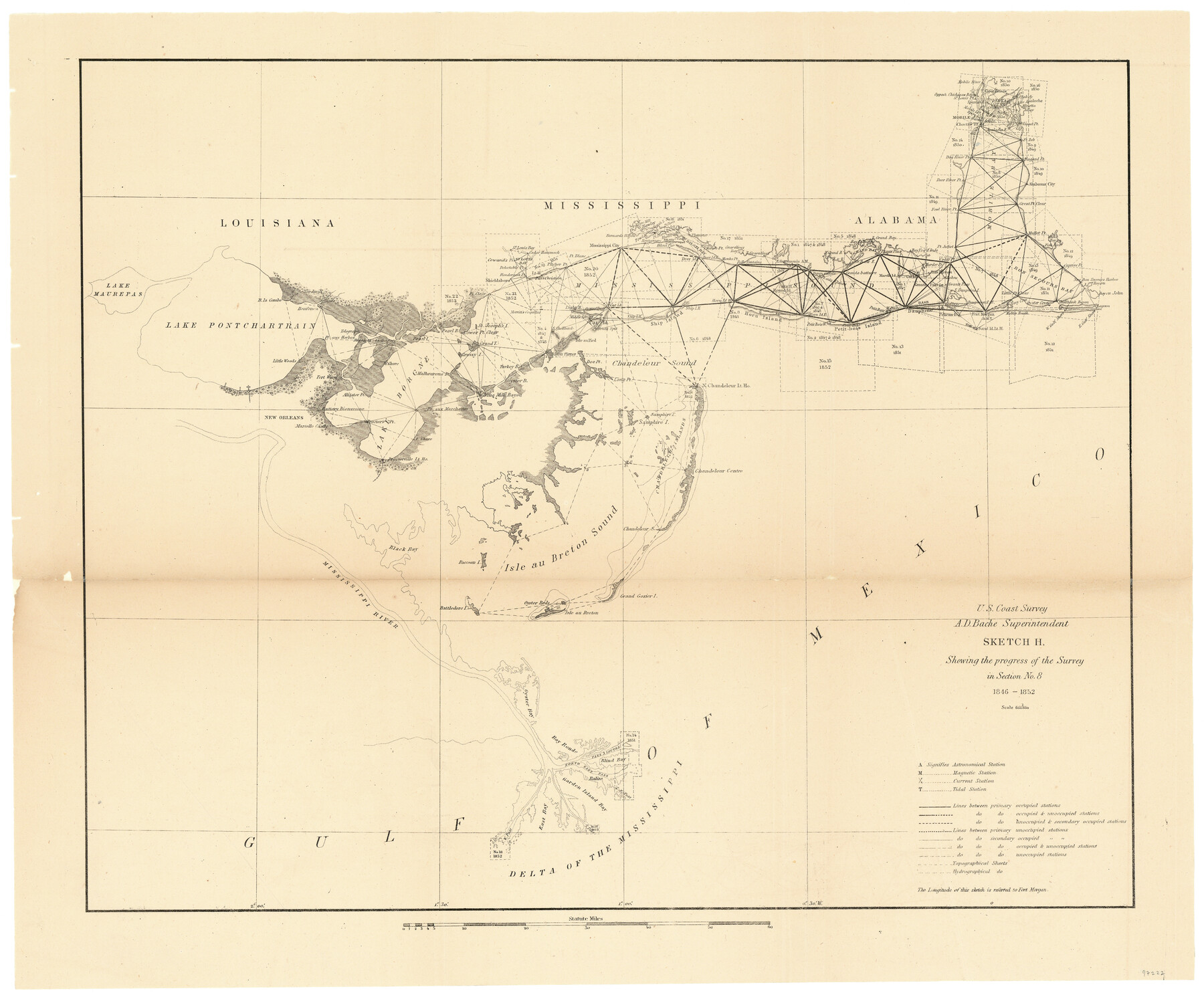
Sketch H Showing the progress of the Survey in Section No. 8
- 
                          Map/Doc
97222
 - 
                            Collection
General Map Collection
 - 
                            Object Dates
1846-1852 (Creation Date)
 - 
                            People and Organizations
A.D. Bache (Superintendent)
U.S. Coast Survey (Publisher)
 - 
                            Subjects
Coastal
 - 
                            Height x Width
17.1 x 20.6 inches
43.4 x 52.3 cm
 - 
                            Comments
Sketch from the book "Report of the Superintendent of the Coast Survey Showing the Progress of the Survey in the year 1852" (81738)
 
Related maps
            Report of the Superintendent of the Coast Survey showing the progress of the survey during the year 1852


            Report of the Superintendent of the Coast Survey showing the progress of the survey during the year 1852
1853
Map/Doc 81738
            Part of: General Map Collection
            Crockett County Sketch File 9


                                            Print $12.00                    
                                             -                         Digital $50.00                                    
                Crockett County Sketch File 9
1881
Size 9.0 x 10.0 inches
                                Map/Doc 19655
            
            Wilbarger County Sketch File 17


                                            Print $4.00                    
                                             -                         Digital $50.00                                    
                Wilbarger County Sketch File 17
1886
Size 14.2 x 8.7 inches
                                Map/Doc 40207
            
            Montgomery County Working Sketch 52


                                            Print $20.00                    
                                             -                         Digital $50.00                                    
                Montgomery County Working Sketch 52
1960
Size 37.8 x 43.3 inches
                                Map/Doc 71159
            
            Jackson County


                                            Print $20.00                    
                                             -                         Digital $50.00                                    
                Jackson County
1840
Size 33.5 x 26.7 inches
                                Map/Doc 4505
            
            Galveston County NRC Article 33.136 Sketch 56


                                            Print $42.00                    
                                             -                         Digital $50.00                                    
                Galveston County NRC Article 33.136 Sketch 56
2009
Size 22.0 x 34.0 inches
                                Map/Doc 94733
            
            Flight Mission No. DAG-28K, Frame 32, Matagorda County


                                            Print $20.00                    
                                             -                         Digital $50.00                                    
                Flight Mission No. DAG-28K, Frame 32, Matagorda County
1953
Size 16.2 x 16.0 inches
                                Map/Doc 86600
            
            Brewster County Rolled Sketch 18B


                                            Print $20.00                    
                                             -                         Digital $50.00                                    
                Brewster County Rolled Sketch 18B
1906
Size 16.2 x 18.1 inches
                                Map/Doc 5197
            
            Crockett County Rolled Sketch 99


                                            Print $20.00                    
                                             -                         Digital $50.00                                    
                Crockett County Rolled Sketch 99
Size 37.2 x 38.2 inches
                                Map/Doc 95401
            
            Motley County Sketch File E1 (S)


                                            Print $8.00                    
                                             -                         Digital $50.00                                    
                Motley County Sketch File E1 (S)
Size 14.3 x 8.7 inches
                                Map/Doc 32175
            
            Brewster County Sketch File NS-5


                                            Print $22.00                    
                                             -                         Digital $50.00                                    
                Brewster County Sketch File NS-5
Size 11.2 x 8.8 inches
                                Map/Doc 15983
            
            Presidio County Sketch File 29


                                            Print $20.00                    
                                             -                         Digital $50.00                                    
                Presidio County Sketch File 29
1890
Size 29.7 x 20.1 inches
                                Map/Doc 11711
            You may also like
            Milam County Rolled Sketch 3A


                                            Print $40.00                    
                                             -                         Digital $50.00                                    
                Milam County Rolled Sketch 3A
1967
Size 49.1 x 38.8 inches
                                Map/Doc 43048
            
            Copy of Surveyor's Field Book, Morris Browning - In Blocks 7, 5 & 4, I&GNRRCo., Hutchinson and Carson Counties, Texas


                                            Print $2.00                    
                                             -                         Digital $50.00                                    
                Copy of Surveyor's Field Book, Morris Browning - In Blocks 7, 5 & 4, I&GNRRCo., Hutchinson and Carson Counties, Texas
1888
Size 6.9 x 8.8 inches
                                Map/Doc 62281
            
            Railroad Track Map, H&TCRRCo., Falls County, Texas


                                            Print $4.00                    
                                             -                         Digital $50.00                                    
                Railroad Track Map, H&TCRRCo., Falls County, Texas
1918
Size 11.7 x 18.5 inches
                                Map/Doc 62842
            
            [Blocks C4, S1, K and C3 in Northern Hale/Southern Swisher Counties]


                                            Print $2.00                    
                                             -                         Digital $50.00                                    
                [Blocks C4, S1, K and C3 in Northern Hale/Southern Swisher Counties]
1906
Size 15.0 x 8.7 inches
                                Map/Doc 91858
            
            Scurry County Rolled Sketch 14


                                            Print $20.00                    
                                             -                         Digital $50.00                                    
                Scurry County Rolled Sketch 14
2016
Size 23.4 x 41.4 inches
                                Map/Doc 95404
            
            [Surveys along the Nueces River, San Patricio District]


                                            Print $2.00                    
                                             -                         Digital $50.00                                    
                [Surveys along the Nueces River, San Patricio District]
1842
Size 11.3 x 7.7 inches
                                Map/Doc 69739
            
            Flight Mission No. BRA-17M, Frame 2, Jefferson County


                                            Print $20.00                    
                                             -                         Digital $50.00                                    
                Flight Mission No. BRA-17M, Frame 2, Jefferson County
1953
Size 18.6 x 22.3 inches
                                Map/Doc 85782
            
            Flight Mission No. DAG-23K, Frame 60, Matagorda County


                                            Print $20.00                    
                                             -                         Digital $50.00                                    
                Flight Mission No. DAG-23K, Frame 60, Matagorda County
1953
Size 15.8 x 15.8 inches
                                Map/Doc 86487
            
            Nouvelle carte du Mexique, du Texas et d'une partie des États Limitrophes


                                            Print $20.00                    
                                             -                         Digital $50.00                                    
                Nouvelle carte du Mexique, du Texas et d'une partie des États Limitrophes
1834
Size 39.5 x 27.2 inches
                                Map/Doc 93764
            
            [Knox County Blk. 44, H&TC]


                                            Print $42.00                    
                                             -                         Digital $50.00                                    
                [Knox County Blk. 44, H&TC]
1892
Size 20.7 x 21.9 inches
                                Map/Doc 89463
            
            Lee County Sketch File 4a


                                            Print $4.00                    
                                             -                         Digital $50.00                                    
                Lee County Sketch File 4a
1860
Size 12.9 x 8.2 inches
                                Map/Doc 29684