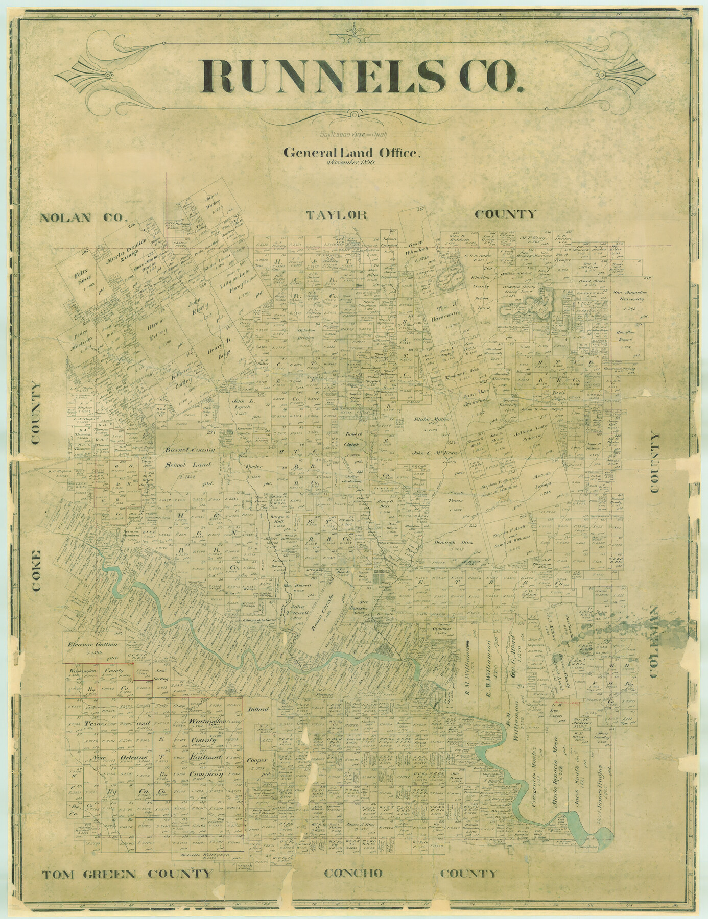
Runnels Co.
-
Map/Doc
16802
-
Collection
General Map Collection
-
Object Dates
1890 (Creation Date)
-
People and Organizations
Texas General Land Office (Publisher)
-
Counties
Runnels
-
Subjects
County
-
Height x Width
50.9 x 39.2 inches
129.3 x 99.6 cm
-
Comments
Adopted by Karl and Marti Gebert.
-
Features
Red Creek
Colorado River
Oath Creek
Janet's Creek
Mary's Creek
Grape Creek
Mustang Creek
Ballinger
Willie's Creek
Quarry Creek
Runnels
Black Creek
Bluff Creek
Valley Creek
Mulatto Creek
Spring Creek
Salt Creek
Oak Creek
Bottomless Lake
Moro Mountain
Table Mountain
Bulger Creek
Fish Creek
Part of: General Map Collection
Milam County Rolled Sketch 3A

Print $40.00
- Digital $50.00
Milam County Rolled Sketch 3A
1967
Size 49.1 x 38.8 inches
Map/Doc 43048
Coke County Boundary File 6

Print $62.00
- Digital $50.00
Coke County Boundary File 6
Size 7.2 x 37.9 inches
Map/Doc 51615
Packery Channel

Print $3.00
- Digital $50.00
Packery Channel
1972
Size 10.6 x 17.8 inches
Map/Doc 2999
Motley County Sketch File 17 (S)

Print $6.00
- Digital $50.00
Motley County Sketch File 17 (S)
1901
Size 14.2 x 8.7 inches
Map/Doc 32189
Stonewall County Rolled Sketch 21

Print $40.00
- Digital $50.00
Stonewall County Rolled Sketch 21
1953
Size 50.8 x 47.9 inches
Map/Doc 9960
Johnson County Rolled Sketch 1

Print $20.00
- Digital $50.00
Johnson County Rolled Sketch 1
1941
Size 19.4 x 33.4 inches
Map/Doc 6446
Bexar County Boundary File 1

Print $26.00
- Digital $50.00
Bexar County Boundary File 1
Size 14.6 x 9.1 inches
Map/Doc 50505
Right of Way and Track Map, the Missouri, Kansas & Texas Ry. Of Texas operated by the Missouri, Kansas & Texas Ry. Of Texas, Houston Division

Print $40.00
- Digital $50.00
Right of Way and Track Map, the Missouri, Kansas & Texas Ry. Of Texas operated by the Missouri, Kansas & Texas Ry. Of Texas, Houston Division
1918
Size 25.6 x 62.5 inches
Map/Doc 64786
Concho County Working Sketch 21

Print $20.00
- Digital $50.00
Concho County Working Sketch 21
1957
Size 36.4 x 36.0 inches
Map/Doc 68203
[Location St. L. & S. W. R. R. Through Cherokee County]
![64044, [Location St. L. & S. W. R. R. Through Cherokee County], General Map Collection](https://historictexasmaps.com/wmedia_w700/maps/64044-1.tif.jpg)
Print $40.00
- Digital $50.00
[Location St. L. & S. W. R. R. Through Cherokee County]
Size 39.2 x 122.1 inches
Map/Doc 64044
Andrews County Rolled Sketch 30

Print $20.00
- Digital $50.00
Andrews County Rolled Sketch 30
Size 20.6 x 18.1 inches
Map/Doc 77174
Hardeman County Working Sketch 5

Print $20.00
- Digital $50.00
Hardeman County Working Sketch 5
Size 23.0 x 35.7 inches
Map/Doc 63386
You may also like
McMullen County Rolled Sketch JR

Print $20.00
- Digital $50.00
McMullen County Rolled Sketch JR
Size 29.6 x 29.6 inches
Map/Doc 6737
Shackelford County Rolled Sketch 2

Print $40.00
- Digital $50.00
Shackelford County Rolled Sketch 2
Size 18.9 x 51.9 inches
Map/Doc 75935
Taylor County Sketch File 16

Print $20.00
- Digital $50.00
Taylor County Sketch File 16
1883
Size 34.3 x 9.0 inches
Map/Doc 12409
Karnes County Sketch File 16

Print $20.00
- Digital $50.00
Karnes County Sketch File 16
1950
Size 14.4 x 30.7 inches
Map/Doc 11905
Sabine River, Toll Bridge Sheet

Print $40.00
- Digital $50.00
Sabine River, Toll Bridge Sheet
1933
Size 27.8 x 51.9 inches
Map/Doc 65136
Map of Fisher and Miller's Colony made from the records in the Office of the District Surveyor of Bexar comprising also all the recent surveys

Print $20.00
- Digital $50.00
Map of Fisher and Miller's Colony made from the records in the Office of the District Surveyor of Bexar comprising also all the recent surveys
1855
Size 27.2 x 39.6 inches
Map/Doc 82026
Intracoastal Waterway in Texas - Corpus Christi to Point Isabel including Arroyo Colorado to Mo. Pac. R.R. Bridge Near Harlingen

Print $20.00
- Digital $50.00
Intracoastal Waterway in Texas - Corpus Christi to Point Isabel including Arroyo Colorado to Mo. Pac. R.R. Bridge Near Harlingen
1933
Size 28.1 x 40.9 inches
Map/Doc 61851
Map of Hemisfair '68 and Downtown San Antonio compliments of the Pearl Brewing Company

Print $3.00
- Digital $50.00
Map of Hemisfair '68 and Downtown San Antonio compliments of the Pearl Brewing Company
1968
Size 5.9 x 11.3 inches
Map/Doc 94792
[Sketch of Hicks Strip No. 2 between M. H. Hagaman and Z. C. Collier Surveys]
![91914, [Sketch of Hicks Strip No. 2 between M. H. Hagaman and Z. C. Collier Surveys], Twichell Survey Records](https://historictexasmaps.com/wmedia_w700/maps/91914-1.tif.jpg)
Print $20.00
- Digital $50.00
[Sketch of Hicks Strip No. 2 between M. H. Hagaman and Z. C. Collier Surveys]
Size 15.3 x 16.3 inches
Map/Doc 91914
Tyler County Sketch File 2

Print $4.00
- Digital $50.00
Tyler County Sketch File 2
Size 6.3 x 5.6 inches
Map/Doc 38615
Flight Mission No. BRE-2P, Frame 49, Nueces County

Print $20.00
- Digital $50.00
Flight Mission No. BRE-2P, Frame 49, Nueces County
1956
Size 18.3 x 22.4 inches
Map/Doc 86751
Edwards County Working Sketch 81

Print $40.00
- Digital $50.00
Edwards County Working Sketch 81
1964
Size 61.4 x 39.6 inches
Map/Doc 68957