Freestone County Boundary File 30b
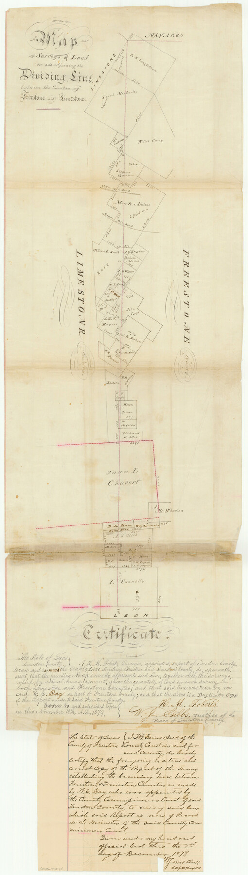
Map of Surveys of Land on and Adjoining the Dividing Line between the Counties of Freestone and Limestone
-
Map/Doc
53598
-
Collection
General Map Collection
-
Counties
Freestone
-
Subjects
County Boundaries
-
Height x Width
43.9 x 12.4 inches
111.5 x 31.5 cm
Part of: General Map Collection
Flight Mission No. BQR-13K, Frame 22, Brazoria County

Print $20.00
- Digital $50.00
Flight Mission No. BQR-13K, Frame 22, Brazoria County
1952
Size 18.9 x 22.4 inches
Map/Doc 84070
Hutchinson County Sketch File 28

Print $6.00
- Digital $50.00
Hutchinson County Sketch File 28
1926
Size 11.3 x 8.8 inches
Map/Doc 27261
Flight Mission No. DQO-8K, Frame79, Galveston County

Print $20.00
- Digital $50.00
Flight Mission No. DQO-8K, Frame79, Galveston County
1952
Size 18.7 x 22.5 inches
Map/Doc 85183
Caldwell County

Print $20.00
- Digital $50.00
Caldwell County
1935
Size 36.1 x 40.3 inches
Map/Doc 77227
Midland County Working Sketch 25

Print $40.00
- Digital $50.00
Midland County Working Sketch 25
1957
Size 58.3 x 49.1 inches
Map/Doc 71006
Lavaca County Working Sketch 3

Print $20.00
- Digital $50.00
Lavaca County Working Sketch 3
1928
Size 22.8 x 27.2 inches
Map/Doc 70356
Jefferson County Aerial Photograph Index Sheet 6

Print $20.00
- Digital $50.00
Jefferson County Aerial Photograph Index Sheet 6
1953
Size 23.3 x 17.0 inches
Map/Doc 83710
Crane County Working Sketch 23

Print $20.00
- Digital $50.00
Crane County Working Sketch 23
1963
Size 25.8 x 23.2 inches
Map/Doc 68300
Brazoria County NRC Article 33.136 Sketch 27

Print $24.00
Brazoria County NRC Article 33.136 Sketch 27
2025
Map/Doc 97472
[Sketch for Mineral Application 13436 - Cut-off Bayou]
![65676, [Sketch for Mineral Application 13436 - Cut-off Bayou], General Map Collection](https://historictexasmaps.com/wmedia_w700/maps/65676.tif.jpg)
Print $20.00
- Digital $50.00
[Sketch for Mineral Application 13436 - Cut-off Bayou]
1928
Size 44.1 x 21.6 inches
Map/Doc 65676
Harris County Historic Topographic 31

Print $20.00
- Digital $50.00
Harris County Historic Topographic 31
1915
Size 29.2 x 22.7 inches
Map/Doc 65842
Upton County Boundary File 1

Print $5.00
- Digital $50.00
Upton County Boundary File 1
Size 13.4 x 9.0 inches
Map/Doc 59506
You may also like
Motley County Sketch File 18 (N)

Print $4.00
- Digital $50.00
Motley County Sketch File 18 (N)
1913
Size 11.3 x 8.7 inches
Map/Doc 32062

[County School Land for Shackelford, Reeves, Hardeman, Val Verde, Hood, Martin, Rusk, Atascosa, and Edwards Counties]
![91114, [County School Land for Shackelford, Reeves, Hardeman, Val Verde, Hood, Martin, Rusk, Atascosa, and Edwards Counties], Twichell Survey Records](https://historictexasmaps.com/wmedia_w700/maps/91114-1.tif.jpg)
Print $2.00
- Digital $50.00
[County School Land for Shackelford, Reeves, Hardeman, Val Verde, Hood, Martin, Rusk, Atascosa, and Edwards Counties]
Size 8.2 x 5.9 inches
Map/Doc 91114
Morris County Rolled Sketch 2A

Print $20.00
- Digital $50.00
Morris County Rolled Sketch 2A
Size 24.3 x 18.7 inches
Map/Doc 10675
Pecos County Sketch File 77

Print $4.00
- Digital $50.00
Pecos County Sketch File 77
1943
Size 11.2 x 8.7 inches
Map/Doc 33909
Aransas County Sketch File 15a

Print $14.00
- Digital $50.00
Aransas County Sketch File 15a
Size 11.0 x 8.4 inches
Map/Doc 13136
FT. W. & R. G. Ry. Right of Way Map, Winchell to Brady, McCulloch County, Texas

Print $40.00
- Digital $50.00
FT. W. & R. G. Ry. Right of Way Map, Winchell to Brady, McCulloch County, Texas
1918
Size 38.0 x 121.9 inches
Map/Doc 61410
Wharton County Sketch File 8

Print $4.00
- Digital $50.00
Wharton County Sketch File 8
1882
Size 8.9 x 10.1 inches
Map/Doc 39927
Flight Mission No. CRE-2R, Frame 88, Jackson County

Print $20.00
- Digital $50.00
Flight Mission No. CRE-2R, Frame 88, Jackson County
1956
Size 15.9 x 15.9 inches
Map/Doc 85360
Flight Mission No. DAG-21K, Frame 30, Matagorda County

Print $20.00
- Digital $50.00
Flight Mission No. DAG-21K, Frame 30, Matagorda County
1952
Size 18.5 x 22.4 inches
Map/Doc 86397
Mileage Map of the Best Roads of Texas showing paved roads, road distances

Print $20.00
- Digital $50.00
Mileage Map of the Best Roads of Texas showing paved roads, road distances
1900
Size 21.7 x 28.7 inches
Map/Doc 95894
Harris County Working Sketch 62

Print $20.00
- Digital $50.00
Harris County Working Sketch 62
1954
Size 41.1 x 37.4 inches
Map/Doc 65954