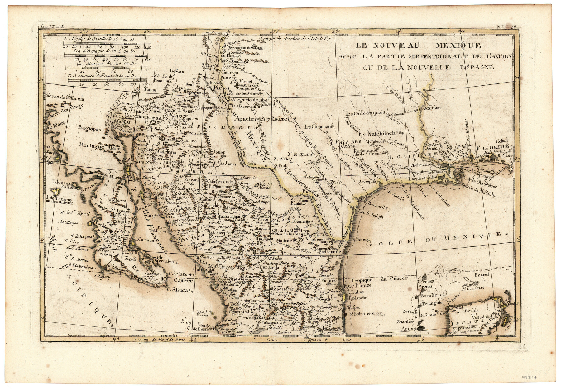
Le Nouveau Mexique avec la partie Septentrionale de l'Ancien ou de la Nouvelle Espagne
-
Map/Doc
97277
-
Collection
General Map Collection
-
Object Dates
[1780] (Creation Date)
-
People and Organizations
Rigobert Bonne (Cartographer)
Chase Untermeyer (Donor)
-
Subjects
Spanish Texas
-
Height x Width
10.0 x 14.4 inches
25.4 x 36.6 cm
-
Comments
Donated by Ambassador Chase Untermeyer in June 2024.
Shows towns, mountains, and rivers in northern Mexico, Louisiana and western Florida.
Relief shown pictorially
Appears in Bonne's Atlas de toutes les parties connues du globe terrestre. [Genève : J.L. Pellet, 1780]
Prime meridians: Isle de Fer and Paris
Outlines hand colored
In upper left margin: Liv. VI et X
In upper right margin: No. 28
Part of: General Map Collection
Titus County Boundary File 3

Print $6.00
- Digital $50.00
Titus County Boundary File 3
Size 7.6 x 6.9 inches
Map/Doc 59300
Hudspeth County Working Sketch 57

Print $20.00
- Digital $50.00
Hudspeth County Working Sketch 57
1992
Size 9.6 x 26.5 inches
Map/Doc 66342
San Patricio County Rolled Sketch 20

Print $20.00
- Digital $50.00
San Patricio County Rolled Sketch 20
1953
Size 37.6 x 31.9 inches
Map/Doc 7578
Blanco County Boundary File 5

Print $100.00
- Digital $50.00
Blanco County Boundary File 5
Size 17.1 x 14.1 inches
Map/Doc 50555
Flight Mission No. CGI-2N, Frame 185, Cameron County

Print $20.00
- Digital $50.00
Flight Mission No. CGI-2N, Frame 185, Cameron County
1954
Size 18.5 x 22.2 inches
Map/Doc 84545
[Ft. W. & R. G. Ry. Right of Way Map, Chapin to Bluffdale, Hood County, Texas]
![64643, [Ft. W. & R. G. Ry. Right of Way Map, Chapin to Bluffdale, Hood County, Texas], General Map Collection](https://historictexasmaps.com/wmedia_w700/maps/64643.tif.jpg)
Print $40.00
- Digital $50.00
[Ft. W. & R. G. Ry. Right of Way Map, Chapin to Bluffdale, Hood County, Texas]
1918
Size 38.8 x 120.3 inches
Map/Doc 64643
Crockett County Working Sketch 42

Print $20.00
- Digital $50.00
Crockett County Working Sketch 42
1930
Size 25.8 x 28.0 inches
Map/Doc 68375
Atascosa County Working Sketch 19

Print $20.00
- Digital $50.00
Atascosa County Working Sketch 19
1952
Size 24.4 x 27.3 inches
Map/Doc 67215
King County Working Sketch 8

Print $20.00
- Digital $50.00
King County Working Sketch 8
1955
Size 30.8 x 24.8 inches
Map/Doc 70172
Val Verde County Sketch File 20

Print $20.00
- Digital $50.00
Val Verde County Sketch File 20
1881
Size 26.5 x 37.2 inches
Map/Doc 12569
Coke County Working Sketch 15

Print $20.00
- Digital $50.00
Coke County Working Sketch 15
1948
Size 25.7 x 21.7 inches
Map/Doc 68052
Flight Mission No. DQN-7K, Frame 13, Calhoun County

Print $20.00
- Digital $50.00
Flight Mission No. DQN-7K, Frame 13, Calhoun County
1953
Size 18.4 x 22.1 inches
Map/Doc 84464
You may also like
[North part] Cass County
![90385, [North part] Cass County, Twichell Survey Records](https://historictexasmaps.com/wmedia_w700/maps/90385-1.tif.jpg)
Print $20.00
- Digital $50.00
[North part] Cass County
1896
Size 37.3 x 19.5 inches
Map/Doc 90385
San Augustine County

Print $20.00
- Digital $50.00
San Augustine County
1871
Size 20.7 x 14.2 inches
Map/Doc 4014
Fannin County Working Sketch 3

Print $20.00
- Digital $50.00
Fannin County Working Sketch 3
1925
Size 22.2 x 30.0 inches
Map/Doc 69157
[East Part of Bailey County and West Part of Lamb County]
![91048, [East Part of Bailey County and West Part of Lamb County], Twichell Survey Records](https://historictexasmaps.com/wmedia_w700/maps/91048-1.tif.jpg)
Print $20.00
- Digital $50.00
[East Part of Bailey County and West Part of Lamb County]
Size 22.5 x 18.3 inches
Map/Doc 91048
Pecos County Sketch File 7

Print $20.00
- Digital $50.00
Pecos County Sketch File 7
Size 29.7 x 44.5 inches
Map/Doc 10568
El Paso County Rolled Sketch 50

Print $40.00
- Digital $50.00
El Paso County Rolled Sketch 50
1956
Size 20.7 x 80.1 inches
Map/Doc 8876

Angelina County Sketch File 11c

Print $7.00
- Digital $50.00
Angelina County Sketch File 11c
Size 11.1 x 6.0 inches
Map/Doc 12946
General Highway Map, Bexar County, Texas

Print $20.00
General Highway Map, Bexar County, Texas
1961
Size 18.3 x 25.0 inches
Map/Doc 79371
Montgomery County Rolled Sketch 29

Print $20.00
- Digital $50.00
Montgomery County Rolled Sketch 29
1948
Size 36.4 x 31.7 inches
Map/Doc 9537
Montague County Sketch File 20

Print $42.00
- Digital $50.00
Montague County Sketch File 20
1923
Size 34.6 x 19.8 inches
Map/Doc 12106
Real County Rolled Sketch 3

Print $20.00
- Digital $50.00
Real County Rolled Sketch 3
1955
Size 14.6 x 23.3 inches
Map/Doc 7453