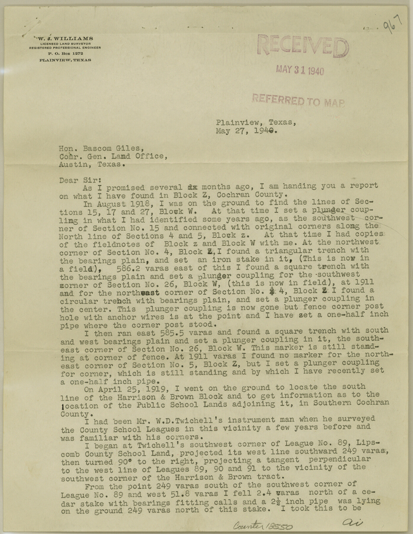
Cochran County Sketch File 7
[Surveyor's explanation regarding Block Z]
-
Map/Doc
18550
-
Collection
General Map Collection
-
Object Dates
1940/5/27 (Creation Date)
1940/5/31 (File Date)
-
People and Organizations
W.J. Williams (Surveyor/Engineer)
-
Counties
Cochran
-
Subjects
Surveying Sketch File
-
Height x Width
11.2 x 8.6 inches
28.4 x 21.8 cm
-
Medium
paper, print
-
Comments
See Cochran County Rolled Sketch 2 (5500) for sketch.
-
Features
Bull Bat Mill
Related maps
Cochran County Rolled Sketch 2

Print $20.00
- Digital $50.00
Cochran County Rolled Sketch 2
1940
Size 27.7 x 33.9 inches
Map/Doc 5500
Part of: General Map Collection
Kendall County Working Sketch 23

Print $20.00
- Digital $50.00
Kendall County Working Sketch 23
1974
Size 21.7 x 24.5 inches
Map/Doc 66695
Bee County Working Sketch 3
Print $20.00
- Digital $50.00
Bee County Working Sketch 3
1915
Size 22.8 x 20.3 inches
Map/Doc 67253
Polk County Rolled Sketch 33

Print $20.00
- Digital $50.00
Polk County Rolled Sketch 33
Size 26.5 x 38.5 inches
Map/Doc 7319
Cottle County Sketch File 8

Print $20.00
- Digital $50.00
Cottle County Sketch File 8
1894
Size 37.6 x 17.6 inches
Map/Doc 11192
Presidio County Rolled Sketch 1

Print $20.00
- Digital $50.00
Presidio County Rolled Sketch 1
Size 24.5 x 15.7 inches
Map/Doc 7325
Tyler County Working Sketch 14

Print $20.00
- Digital $50.00
Tyler County Working Sketch 14
1959
Size 24.8 x 30.9 inches
Map/Doc 69484
Wichita County Rolled Sketch 14

Print $20.00
- Digital $50.00
Wichita County Rolled Sketch 14
1927
Size 36.7 x 30.5 inches
Map/Doc 8251
Gonzales County Sketch File 3

Print $24.00
- Digital $50.00
Gonzales County Sketch File 3
1871
Size 12.6 x 8.3 inches
Map/Doc 24361
Flight Mission No. BQR-22K, Frame 38, Brazoria County

Print $20.00
- Digital $50.00
Flight Mission No. BQR-22K, Frame 38, Brazoria County
1953
Size 18.5 x 22.3 inches
Map/Doc 84122
Menard County Boundary File 1

Print $14.00
- Digital $50.00
Menard County Boundary File 1
Size 12.7 x 8.1 inches
Map/Doc 57035
Harris County Historic Topographic 17

Print $20.00
- Digital $50.00
Harris County Historic Topographic 17
1916
Size 29.5 x 22.7 inches
Map/Doc 65827
Hutchinson County Boundary File 4

Print $17.00
- Digital $50.00
Hutchinson County Boundary File 4
Size 14.3 x 8.7 inches
Map/Doc 55305
You may also like
Red River County Working Sketch 43

Print $40.00
- Digital $50.00
Red River County Working Sketch 43
1968
Size 72.5 x 36.8 inches
Map/Doc 72026
DeWitt County Working Sketch 12

Print $20.00
- Digital $50.00
DeWitt County Working Sketch 12
1981
Size 17.0 x 12.5 inches
Map/Doc 68602
[Surveys near Carancahua Bay]
![106, [Surveys near Carancahua Bay], General Map Collection](https://historictexasmaps.com/wmedia_w700/maps/106.tif.jpg)
Print $2.00
- Digital $50.00
[Surveys near Carancahua Bay]
1844
Size 13.1 x 8.0 inches
Map/Doc 106
Flight Mission No. DQN-2K, Frame 80, Calhoun County

Print $20.00
- Digital $50.00
Flight Mission No. DQN-2K, Frame 80, Calhoun County
1953
Size 18.4 x 22.2 inches
Map/Doc 84272
Haskell County Working Sketch 2

Print $3.00
- Digital $50.00
Haskell County Working Sketch 2
1914
Size 14.9 x 10.1 inches
Map/Doc 66060
Tarrant County Working Sketch 19

Print $20.00
- Digital $50.00
Tarrant County Working Sketch 19
1999
Size 11.8 x 18.1 inches
Map/Doc 62436
Bastrop County Working Sketch 15

Print $20.00
- Digital $50.00
Bastrop County Working Sketch 15
1993
Size 23.5 x 21.1 inches
Map/Doc 67315
Brewster County Working Sketch 71b

Print $40.00
- Digital $50.00
Brewster County Working Sketch 71b
1961
Size 50.6 x 55.0 inches
Map/Doc 67870
Comal County Sketch File 20

Print $6.00
- Digital $50.00
Comal County Sketch File 20
1857
Size 12.4 x 8.1 inches
Map/Doc 19039
Crockett County Working Sketch 33

Print $20.00
- Digital $50.00
Crockett County Working Sketch 33
1926
Size 27.0 x 32.8 inches
Map/Doc 68366
Flight Mission No. CLL-1N, Frame 182, Willacy County

Print $20.00
- Digital $50.00
Flight Mission No. CLL-1N, Frame 182, Willacy County
1954
Size 18.4 x 22.0 inches
Map/Doc 87052
