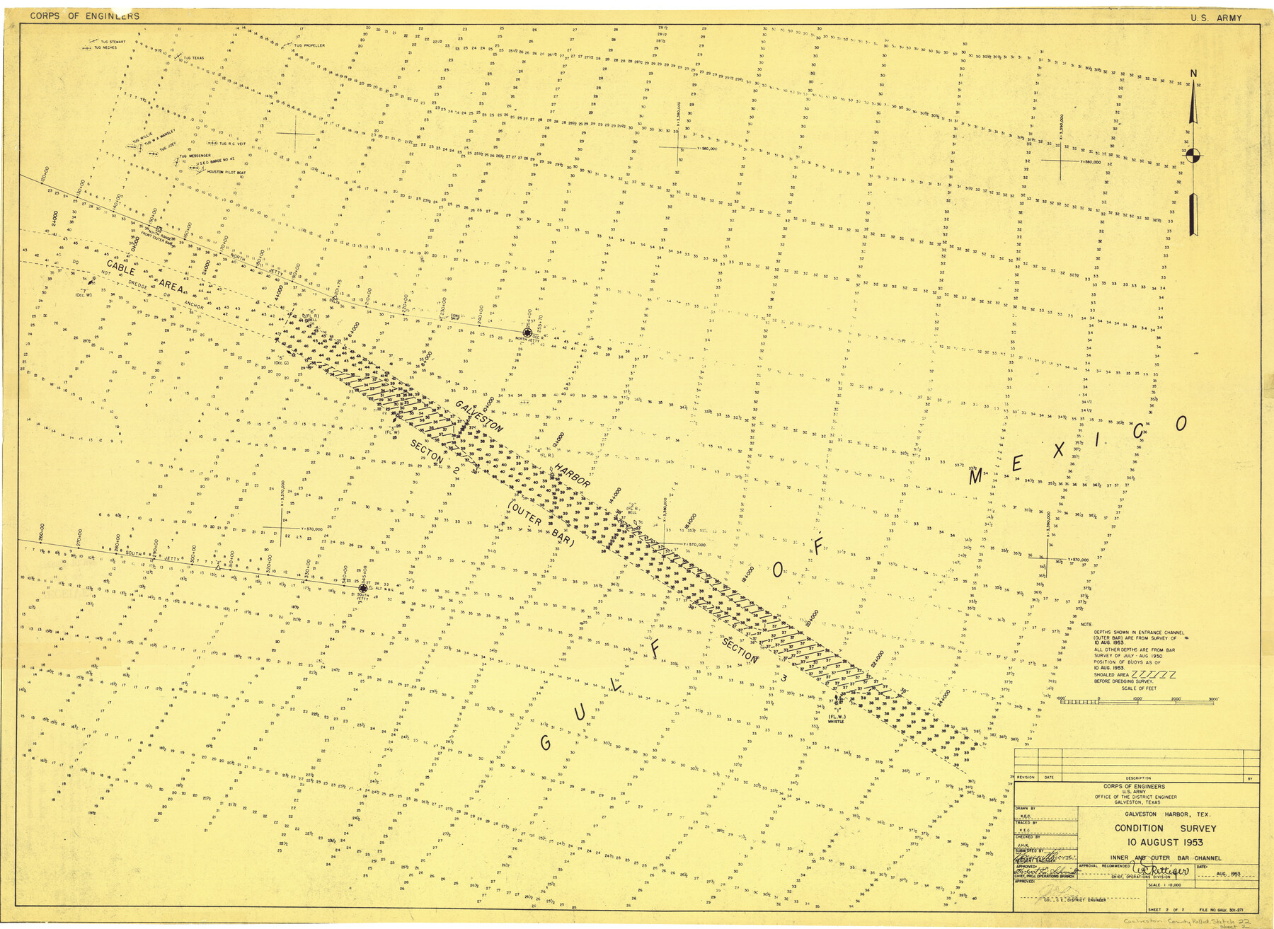
Galveston County Rolled Sketch 22
Galveston Harbor - Condition Survey
-
Map/Doc
9663
-
Collection
General Map Collection
-
Object Dates
8/10/1953 (Creation Date)
-
Counties
Galveston
-
Subjects
Surveying Rolled Sketch
-
Height x Width
28.8 x 39.5 inches
73.2 x 100.3 cm
-
Comments
Sheet 2 of 2. For sheet 1 see 9083.
Related maps
Galveston County Rolled Sketch 22

Print $20.00
- Digital $50.00
Galveston County Rolled Sketch 22
1953
Size 29.6 x 40.8 inches
Map/Doc 9083
Part of: General Map Collection
Coke County Rolled Sketch 23

Print $20.00
- Digital $50.00
Coke County Rolled Sketch 23
1944
Size 13.7 x 14.7 inches
Map/Doc 5524
Franklin County

Print $20.00
- Digital $50.00
Franklin County
1897
Size 35.1 x 14.3 inches
Map/Doc 3556
Rio Grande, Harlingen Sheet

Print $20.00
- Digital $50.00
Rio Grande, Harlingen Sheet
1935
Size 37.2 x 37.2 inches
Map/Doc 65113
Haskell County Boundary File 7

Print $40.00
- Digital $50.00
Haskell County Boundary File 7
Size 3.6 x 38.5 inches
Map/Doc 54584
Presidio County Rolled Sketch T-1

Print $20.00
- Digital $50.00
Presidio County Rolled Sketch T-1
Size 26.8 x 27.1 inches
Map/Doc 7416
Aransas County Rolled Sketch 27A

Print $2.00
- Digital $50.00
Aransas County Rolled Sketch 27A
1930
Size 8.9 x 7.2 inches
Map/Doc 5058
Live Oak County Working Sketch 16

Print $20.00
- Digital $50.00
Live Oak County Working Sketch 16
1954
Size 22.2 x 21.8 inches
Map/Doc 70601
Matagorda County Sketch File 46

Print $107.00
- Digital $50.00
Matagorda County Sketch File 46
1985
Size 11.2 x 8.5 inches
Map/Doc 30932

Brazoria County Rolled Sketch CL

Print $20.00
- Digital $50.00
Brazoria County Rolled Sketch CL
1934
Size 22.0 x 32.8 inches
Map/Doc 8463
Jefferson County Sketch File 28

Print $2.00
- Digital $50.00
Jefferson County Sketch File 28
1900
Size 9.2 x 8.6 inches
Map/Doc 28193
Flight Mission No. CGI-1N, Frame 184, Cameron County

Print $20.00
- Digital $50.00
Flight Mission No. CGI-1N, Frame 184, Cameron County
1955
Size 18.5 x 22.2 inches
Map/Doc 84519
You may also like
Presidio County Rolled Sketch 114

Print $20.00
- Digital $50.00
Presidio County Rolled Sketch 114
Size 28.2 x 40.3 inches
Map/Doc 7390
Orange County Working Sketch 31

Print $20.00
- Digital $50.00
Orange County Working Sketch 31
1955
Size 24.2 x 13.8 inches
Map/Doc 71363
General Highway Map. Detail of Cities and Towns in Galveston County, Texas [Galveston and vicinity]
![79097, General Highway Map. Detail of Cities and Towns in Galveston County, Texas [Galveston and vicinity], Texas State Library and Archives](https://historictexasmaps.com/wmedia_w700/maps/79097.tif.jpg)
Print $20.00
General Highway Map. Detail of Cities and Towns in Galveston County, Texas [Galveston and vicinity]
1939
Size 18.4 x 25.0 inches
Map/Doc 79097
Right of Way and Track Map, Houston & Texas Central R.R. operated by the T. and N. O. R.R., Fort Worth Branch

Print $40.00
- Digital $50.00
Right of Way and Track Map, Houston & Texas Central R.R. operated by the T. and N. O. R.R., Fort Worth Branch
1918
Size 31.9 x 57.7 inches
Map/Doc 64779
Presidio County Working Sketch 101

Print $20.00
- Digital $50.00
Presidio County Working Sketch 101
1979
Size 37.6 x 31.0 inches
Map/Doc 71778
Williamson County Sketch File 31

Print $14.00
- Digital $50.00
Williamson County Sketch File 31
1991
Size 11.2 x 8.4 inches
Map/Doc 40386
Flight Mission No. DIX-5P, Frame 108, Aransas County

Print $20.00
- Digital $50.00
Flight Mission No. DIX-5P, Frame 108, Aransas County
1956
Size 17.2 x 18.1 inches
Map/Doc 83787
Cottle County Sketch File 3a

Print $14.00
- Digital $50.00
Cottle County Sketch File 3a
Size 12.9 x 8.8 inches
Map/Doc 19459
Roberts County Working Sketch 2

Print $20.00
- Digital $50.00
Roberts County Working Sketch 2
1939
Size 10.8 x 17.7 inches
Map/Doc 63528
Brewster County Rolled Sketch 60

Print $20.00
- Digital $50.00
Brewster County Rolled Sketch 60
Size 24.8 x 36.5 inches
Map/Doc 61783
Map of Jones County

Print $20.00
- Digital $50.00
Map of Jones County
1898
Size 41.2 x 40.0 inches
Map/Doc 16862
Flight Mission No. BRA-16M, Frame 129, Jefferson County

Print $20.00
- Digital $50.00
Flight Mission No. BRA-16M, Frame 129, Jefferson County
1953
Size 18.4 x 22.7 inches
Map/Doc 85739