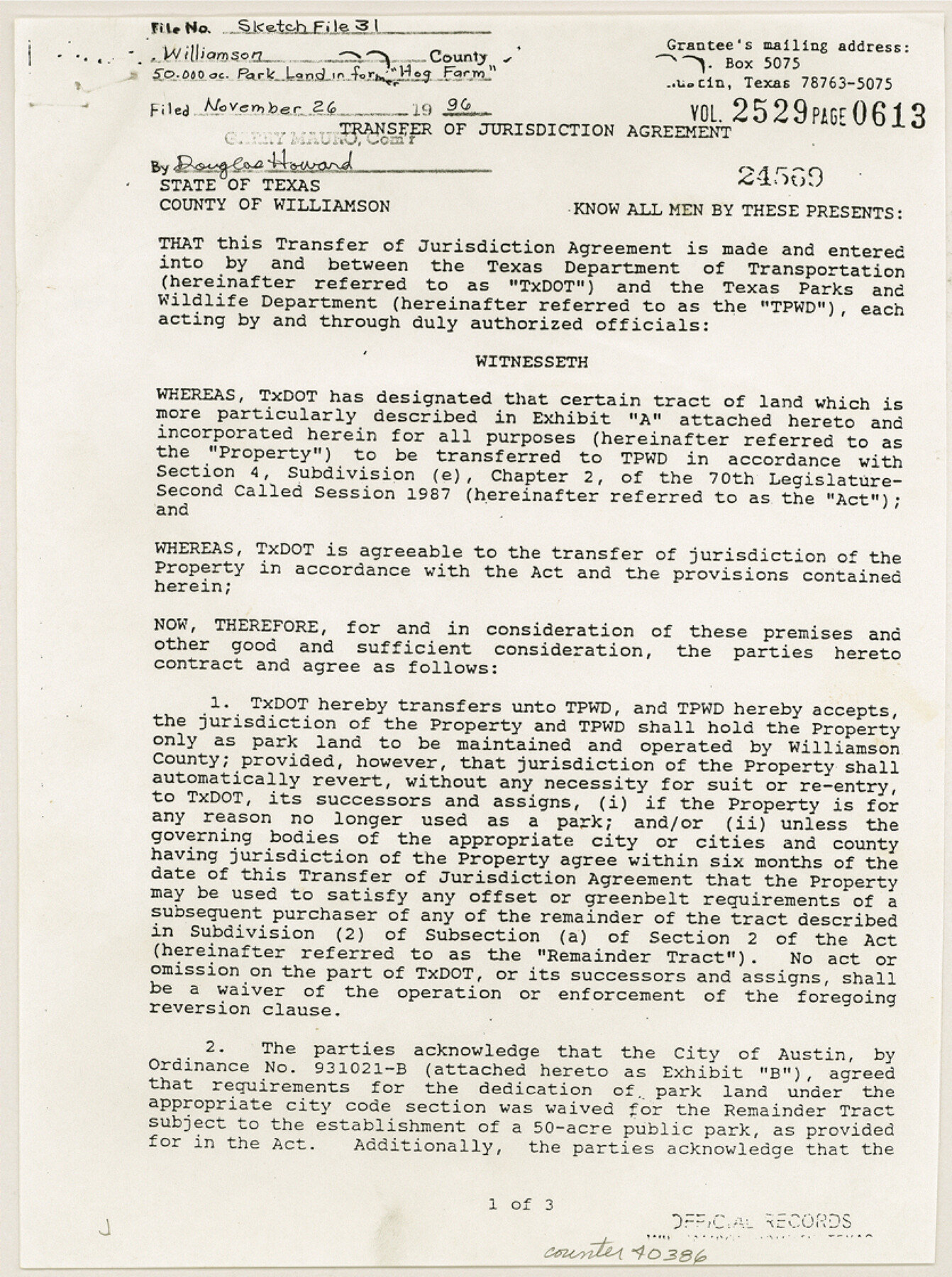
Williamson County Sketch File 31
[Transfer of jurisdiction agreement for 50 acres of park land in former "Hog Farm" located in the Samuel Damon survey southwest from Georgetown]
-
Map/Doc
40386
-
Collection
General Map Collection
-
Object Dates
1991-1993 (Creation Date)
11/26/1996 (File Date)
-
Counties
Williamson
-
Subjects
Surveying Sketch File
-
Height x Width
11.2 x 8.4 inches
28.5 x 21.3 cm
-
Medium
paper, print
-
Features
Austin
U.S. Highway 183
Part of: General Map Collection
Comal County Sketch File 3

Print $8.00
- Digital $50.00
Comal County Sketch File 3
1853
Size 4.4 x 8.4 inches
Map/Doc 18999
Upton County Rolled Sketch 59

Print $40.00
- Digital $50.00
Upton County Rolled Sketch 59
Size 37.8 x 48.4 inches
Map/Doc 10062
Blanco County Working Sketch 31

Print $20.00
- Digital $50.00
Blanco County Working Sketch 31
1972
Size 19.1 x 25.7 inches
Map/Doc 67391
Jones County Boundary File 1b

Print $40.00
- Digital $50.00
Jones County Boundary File 1b
1882
Size 37.5 x 12.6 inches
Map/Doc 44359
Flight Mission No. BQY-4M, Frame 41, Harris County

Print $20.00
- Digital $50.00
Flight Mission No. BQY-4M, Frame 41, Harris County
1953
Size 18.6 x 22.4 inches
Map/Doc 85256
Bailey County Sketch File 17

Print $12.00
- Digital $50.00
Bailey County Sketch File 17
Size 10.9 x 7.4 inches
Map/Doc 13980
Val Verde County Working Sketch 82

Print $20.00
- Digital $50.00
Val Verde County Working Sketch 82
1973
Size 42.1 x 33.1 inches
Map/Doc 72217
Jeff Davis County Sketch File 19

Print $10.00
- Digital $50.00
Jeff Davis County Sketch File 19
1908
Size 14.4 x 8.8 inches
Map/Doc 27973
Sterling County

Print $20.00
- Digital $50.00
Sterling County
1971
Size 44.7 x 33.4 inches
Map/Doc 73294
Flight Mission No. DAG-22K, Frame 87, Matagorda County

Print $20.00
- Digital $50.00
Flight Mission No. DAG-22K, Frame 87, Matagorda County
1953
Size 18.6 x 22.4 inches
Map/Doc 86471
Floyd County Sketch File 22

Print $4.00
- Digital $50.00
Floyd County Sketch File 22
Size 8.8 x 8.0 inches
Map/Doc 22774
Bee County Working Sketch 34

Print $20.00
- Digital $50.00
Bee County Working Sketch 34
1988
Size 46.3 x 43.6 inches
Map/Doc 67285
You may also like
Fort Bend County Sketch File 15

Print $5.00
- Digital $50.00
Fort Bend County Sketch File 15
Size 11.9 x 12.8 inches
Map/Doc 22925
Motley County Sketch File 27 (S)

Print $6.00
- Digital $50.00
Motley County Sketch File 27 (S)
Size 14.3 x 8.3 inches
Map/Doc 32208
[Sketch of Potter County Road, North of River]
![93058, [Sketch of Potter County Road, North of River], Twichell Survey Records](https://historictexasmaps.com/wmedia_w700/maps/93058-1.tif.jpg)
Print $3.00
- Digital $50.00
[Sketch of Potter County Road, North of River]
Size 9.6 x 15.0 inches
Map/Doc 93058
Armstrong County Sketch File A-12

Print $40.00
- Digital $50.00
Armstrong County Sketch File A-12
Size 41.3 x 18.5 inches
Map/Doc 10374
Hall County Sketch File 35

Print $22.00
- Digital $50.00
Hall County Sketch File 35
1913
Size 11.2 x 8.8 inches
Map/Doc 24884
Brewster County Working Sketch 77

Print $20.00
- Digital $50.00
Brewster County Working Sketch 77
1968
Size 25.0 x 20.9 inches
Map/Doc 67677
[Right of Way & Track Map, The Texas & Pacific Ry. Co. Main Line]
![64688, [Right of Way & Track Map, The Texas & Pacific Ry. Co. Main Line], General Map Collection](https://historictexasmaps.com/wmedia_w700/maps/64688.tif.jpg)
Print $20.00
- Digital $50.00
[Right of Way & Track Map, The Texas & Pacific Ry. Co. Main Line]
Size 11.0 x 19.0 inches
Map/Doc 64688
Wharton County Sketch File A2

Print $32.00
- Digital $50.00
Wharton County Sketch File A2
1898
Size 22.1 x 15.7 inches
Map/Doc 12670
Throckmorton County Sketch File 12

Print $20.00
- Digital $50.00
Throckmorton County Sketch File 12
Size 16.2 x 22.3 inches
Map/Doc 12435
Crockett County Sketch File 73

Print $6.00
- Digital $50.00
Crockett County Sketch File 73
1933
Size 11.2 x 8.7 inches
Map/Doc 19869
Colorado County Working Sketch 11

Print $3.00
- Digital $50.00
Colorado County Working Sketch 11
1942
Size 10.6 x 16.5 inches
Map/Doc 68111
Bexar County Sketch File 3

Print $4.00
- Digital $50.00
Bexar County Sketch File 3
Size 12.8 x 8.3 inches
Map/Doc 14473