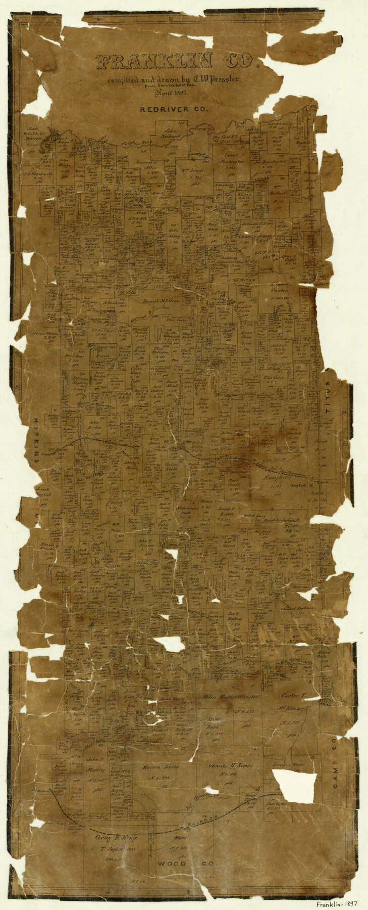
Franklin County
-
Map/Doc
3556
-
Collection
General Map Collection
-
Object Dates
4/1897 (Creation Date)
-
People and Organizations
Chas. W. Pressler (Draftsman)
-
Counties
Franklin
-
Subjects
County
-
Height x Width
35.1 x 14.3 inches
89.2 x 36.3 cm
-
Features
Cypress Creek
Ripley's Creek
Gray Rock
Blundell's Creek
Andy's Creek
Titus Creek
Panther Creek
Smith's Creek
Cedar Creek
Mount Vernon
Mountain Creek
Blair's Creek
Big Cypress Creek
Glade Creek
Caddo Creek
EL&RR
Dry Cypress Creek
Sulphur Fork
Denton's Creek
SL&SW
Big Creek
Bearpen Creek
Lick Creek
Campbell's Creek
Prairie Creek
Whiteoak Bayou
Mitchell's Creek
East Creek
Stoney Creek
Cob Jones Creek
Lewis Creek
South Fork [of Sulphur Fork]
North Fork [of Sulphur Fork]
Part of: General Map Collection
Houston County Sketch File 39

Print $6.00
- Digital $50.00
Houston County Sketch File 39
1845
Size 17.0 x 10.9 inches
Map/Doc 26824
Strip Map of Texas-Oklahoma Boundary from Denison East to the Oklahoma-Arkansas State Line

Print $20.00
- Digital $50.00
Strip Map of Texas-Oklahoma Boundary from Denison East to the Oklahoma-Arkansas State Line
1933
Size 37.7 x 24.5 inches
Map/Doc 75927
Kinney County Working Sketch 28

Print $20.00
- Digital $50.00
Kinney County Working Sketch 28
1957
Size 33.3 x 34.4 inches
Map/Doc 70210

Donley County Sketch File 30

Print $24.00
- Digital $50.00
Donley County Sketch File 30
1906
Size 11.3 x 8.7 inches
Map/Doc 21270
Brewster County Rolled Sketch 95

Print $20.00
- Digital $50.00
Brewster County Rolled Sketch 95
1947
Size 29.4 x 38.0 inches
Map/Doc 5252
[Val Verde County]
![63097, [Val Verde County], General Map Collection](https://historictexasmaps.com/wmedia_w700/maps/63097.tif.jpg)
Print $20.00
- Digital $50.00
[Val Verde County]
1898
Size 41.1 x 37.1 inches
Map/Doc 63097
Zapata County Rolled Sketch 19

Print $20.00
- Digital $50.00
Zapata County Rolled Sketch 19
1955
Size 29.0 x 20.9 inches
Map/Doc 8316
Hardin County Sketch File 5a

Print $6.00
- Digital $50.00
Hardin County Sketch File 5a
Size 8.1 x 3.5 inches
Map/Doc 25094
Colorado River, New Taiton Sheet

Print $6.00
- Digital $50.00
Colorado River, New Taiton Sheet
1939
Size 27.4 x 35.4 inches
Map/Doc 65313
Anderson County Working Sketch 38

Print $20.00
- Digital $50.00
Anderson County Working Sketch 38
1985
Size 43.3 x 45.9 inches
Map/Doc 67038
Crockett County Sketch File 84

Print $6.00
- Digital $50.00
Crockett County Sketch File 84
1942
Size 11.4 x 8.9 inches
Map/Doc 19905
You may also like
[General Highway Map Supplementary Sheet Showing Detail of Cities and Towns in Bexar County Texas]
![76289, [General Highway Map Supplementary Sheet Showing Detail of Cities and Towns in Bexar County Texas], Texas State Library and Archives](https://historictexasmaps.com/wmedia_w700/maps/76289.tif.jpg)
Print $20.00
[General Highway Map Supplementary Sheet Showing Detail of Cities and Towns in Bexar County Texas]
1936
Size 18.7 x 24.9 inches
Map/Doc 76289
Flight Mission No. DQN-1K, Frame 116, Calhoun County

Print $20.00
- Digital $50.00
Flight Mission No. DQN-1K, Frame 116, Calhoun County
1953
Size 18.7 x 22.4 inches
Map/Doc 84182
[Blocks M-22, M-25 and vicinity]
![91235, [Blocks M-22, M-25 and vicinity], Twichell Survey Records](https://historictexasmaps.com/wmedia_w700/maps/91235-1.tif.jpg)
Print $20.00
- Digital $50.00
[Blocks M-22, M-25 and vicinity]
Size 27.4 x 25.2 inches
Map/Doc 91235
Dickens County Rolled Sketch 14

Print $40.00
- Digital $50.00
Dickens County Rolled Sketch 14
1981
Size 36.5 x 80.7 inches
Map/Doc 8792
Arizona Chemical Co. Brownfield Plant

Print $20.00
- Digital $50.00
Arizona Chemical Co. Brownfield Plant
Size 28.3 x 19.9 inches
Map/Doc 92892
The Republic County of Refugio. December 29, 1845

Print $20.00
The Republic County of Refugio. December 29, 1845
2020
Size 22.3 x 21.6 inches
Map/Doc 96258
Zapata County Rolled Sketch 26

Print $20.00
- Digital $50.00
Zapata County Rolled Sketch 26
1982
Size 43.0 x 30.7 inches
Map/Doc 8319
[Blocks O, N, 34, B19, B29]
![92969, [Blocks O, N, 34, B19, B29], Twichell Survey Records](https://historictexasmaps.com/wmedia_w700/maps/92969-1.tif.jpg)
Print $20.00
- Digital $50.00
[Blocks O, N, 34, B19, B29]
Size 24.1 x 24.4 inches
Map/Doc 92969
Fort Bend County Sketch File 27

Print $20.00
- Digital $50.00
Fort Bend County Sketch File 27
1910
Size 17.9 x 37.7 inches
Map/Doc 10453
Travis County Appraisal District Plat Map 2_1004

Print $20.00
- Digital $50.00
Travis County Appraisal District Plat Map 2_1004
Size 21.4 x 26.5 inches
Map/Doc 94238
Williamson County State Real Property Sketch 1

Print $20.00
- Digital $50.00
Williamson County State Real Property Sketch 1
1985
Size 46.1 x 36.2 inches
Map/Doc 61692
General Highway Map, Collin County, Texas

Print $20.00
General Highway Map, Collin County, Texas
1939
Size 18.6 x 25.0 inches
Map/Doc 79052