Galveston County Rolled Sketch 22
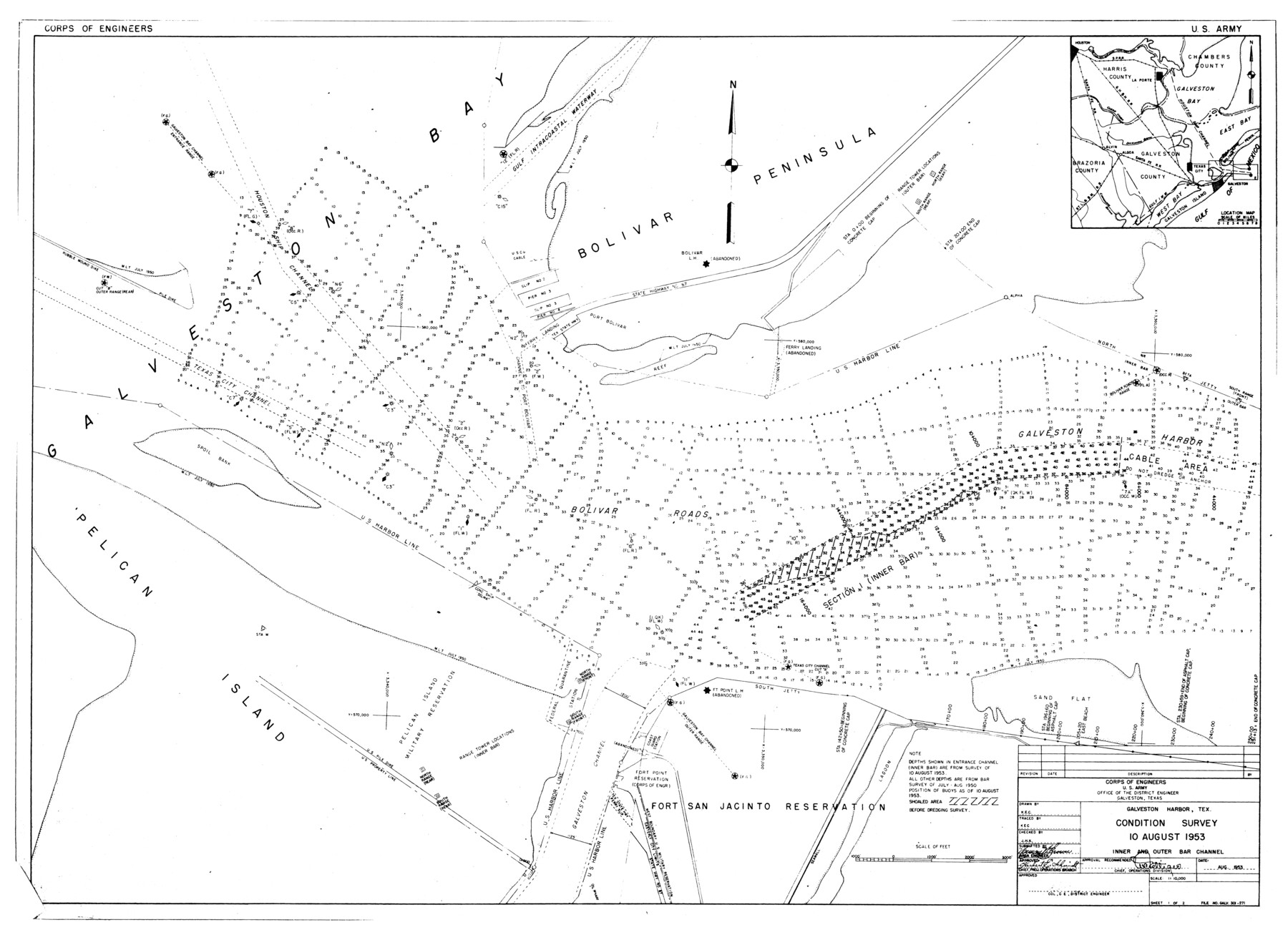
Galveston Harbor, Tex. Condition Survey, 10 August, 1953, Inner and Outer Bar Channel
-
Map/Doc
9083
-
Collection
General Map Collection
-
Object Dates
1953 (Creation Date)
1976/2/10 (File Date)
-
Counties
Galveston
-
Subjects
Surveying Rolled Sketch
-
Height x Width
29.6 x 40.8 inches
75.2 x 103.6 cm
-
Comments
Sheet 1 of 2. For sheet 2 see 9663.
Related maps
Galveston County Rolled Sketch 22

Print $20.00
- Digital $50.00
Galveston County Rolled Sketch 22
1953
Size 28.8 x 39.5 inches
Map/Doc 9663
Part of: General Map Collection
Fisher County Rolled Sketch 3

Print $20.00
- Digital $50.00
Fisher County Rolled Sketch 3
Size 40.5 x 38.6 inches
Map/Doc 8887
Reagan County Sketch File 9

Print $20.00
- Digital $50.00
Reagan County Sketch File 9
1928
Size 27.0 x 22.3 inches
Map/Doc 12216
Refugio County Sketch File 17a

Print $2.00
- Digital $50.00
Refugio County Sketch File 17a
1916
Size 11.4 x 9.0 inches
Map/Doc 35275
Schleicher County Working Sketch 12

Print $20.00
- Digital $50.00
Schleicher County Working Sketch 12
1925
Size 23.7 x 22.2 inches
Map/Doc 63814
Hardin County Working Sketch 29

Print $20.00
- Digital $50.00
Hardin County Working Sketch 29
1958
Size 36.7 x 22.1 inches
Map/Doc 63427
Hill County Sketch File 22

Print $8.00
- Digital $50.00
Hill County Sketch File 22
1860
Size 7.7 x 8.2 inches
Map/Doc 26505
Right of Way and Track Map, The Missouri, Kansas and Texas Ry. of Texas operated by the Missouri, Kansas and Texas Ry. of Texas, Henrietta Division

Print $40.00
- Digital $50.00
Right of Way and Track Map, The Missouri, Kansas and Texas Ry. of Texas operated by the Missouri, Kansas and Texas Ry. of Texas, Henrietta Division
1918
Size 25.4 x 56.3 inches
Map/Doc 64068
Flight Mission No. DCL-7C, Frame 114, Kenedy County

Print $20.00
- Digital $50.00
Flight Mission No. DCL-7C, Frame 114, Kenedy County
1943
Size 18.6 x 22.2 inches
Map/Doc 86079
Crockett County Sketch File 75a

Print $6.00
- Digital $50.00
Crockett County Sketch File 75a
Size 14.2 x 8.8 inches
Map/Doc 19873
Newton County Sketch File 4a

Print $4.00
- Digital $50.00
Newton County Sketch File 4a
Size 12.6 x 8.0 inches
Map/Doc 32362
Webb County Rolled Sketch 57

Print $20.00
- Digital $50.00
Webb County Rolled Sketch 57
Size 23.5 x 32.2 inches
Map/Doc 8209
Calhoun County Rolled Sketch 26

Print $20.00
- Digital $50.00
Calhoun County Rolled Sketch 26
1941
Size 10.9 x 39.9 inches
Map/Doc 5374
You may also like
Layout of the porciones as described in the Visita General of Mier, 1767

Layout of the porciones as described in the Visita General of Mier, 1767
2009
Size 11.0 x 8.5 inches
Map/Doc 94043

Castro County Sketch File 8

Print $20.00
- Digital $50.00
Castro County Sketch File 8
1908
Size 27.2 x 24.0 inches
Map/Doc 11060
Pecos County Sketch File 31 1/2

Print $20.00
- Digital $50.00
Pecos County Sketch File 31 1/2
1931
Size 34.3 x 23.4 inches
Map/Doc 12174
Dimmit County Sketch File 43

Print $20.00
- Digital $50.00
Dimmit County Sketch File 43
1905
Size 22.1 x 19.2 inches
Map/Doc 11353
[Survey 9, Block 9 Potter and Randall]
![91720, [Survey 9, Block 9 Potter and Randall], Twichell Survey Records](https://historictexasmaps.com/wmedia_w700/maps/91720-1.tif.jpg)
Print $20.00
- Digital $50.00
[Survey 9, Block 9 Potter and Randall]
Size 22.3 x 15.9 inches
Map/Doc 91720
Brewster County Sketch File NS-2

Print $14.00
- Digital $50.00
Brewster County Sketch File NS-2
1913
Size 14.3 x 8.8 inches
Map/Doc 15946
Montague County Working Sketch 7

Print $20.00
- Digital $50.00
Montague County Working Sketch 7
1927
Size 41.1 x 28.4 inches
Map/Doc 75970
PSL Field Notes for Block CS in Hartley County

PSL Field Notes for Block CS in Hartley County
Map/Doc 81656
Taylor County Working Sketch 4a

Print $20.00
- Digital $50.00
Taylor County Working Sketch 4a
1944
Size 17.2 x 14.0 inches
Map/Doc 69613
Travis County Sketch File 4A

Print $8.00
- Digital $50.00
Travis County Sketch File 4A
1855
Size 8.4 x 11.2 inches
Map/Doc 38280
General Highway Map. Detail of Cities and Towns in Bee County, Texas. City Map of Beeville, Bee County, Texas

Print $20.00
General Highway Map. Detail of Cities and Towns in Bee County, Texas. City Map of Beeville, Bee County, Texas
1961
Size 25.0 x 18.2 inches
Map/Doc 79365