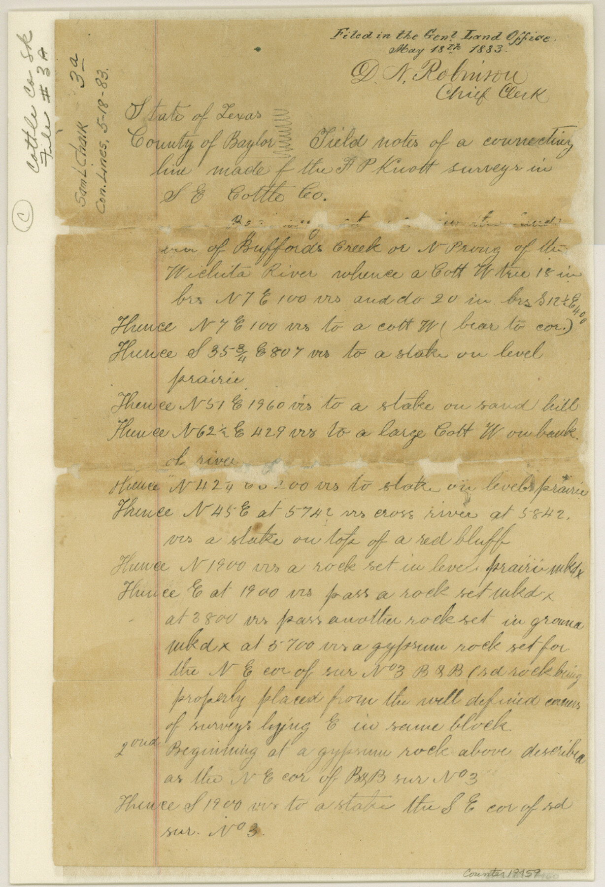
Cottle County Sketch File 3a
[Field notes of a connecting line made of the F. P. Knott surveys in southeast Cottle County]
-
Map/Doc
19459
-
Collection
General Map Collection
-
Object Dates
1883/5/18 (File Date)
-
People and Organizations
S.L. Chalk (Surveyor/Engineer)
D.N. Robinson (GLO Clerk)
Walter Bailes (Chainman)
Frank Mongomery [sic] (Chainman)
Jmes E. Majors (Chainman)
W.H. Martin (Chainman)
-
Counties
Cottle
-
Subjects
Surveying Sketch File
-
Height x Width
12.9 x 8.8 inches
32.8 x 22.4 cm
-
Medium
paper, manuscript
-
Features
Bufford's Creek
North Prong of Wichita River
Buffalo Hump Mountain
Dixie Mountain
Part of: General Map Collection
Flight Mission No. BRE-1P, Frame 47, Nueces County

Print $20.00
- Digital $50.00
Flight Mission No. BRE-1P, Frame 47, Nueces County
1956
Size 18.4 x 22.3 inches
Map/Doc 86636
Guadalupe County Sketch File 24

Print $4.00
- Digital $50.00
Guadalupe County Sketch File 24
1838
Size 12.9 x 8.4 inches
Map/Doc 24715
El Paso County Sketch File 1

Print $48.00
- Digital $50.00
El Paso County Sketch File 1
1849
Size 8.9 x 8.2 inches
Map/Doc 21883
Texas, Corpus Christi, Corpus Christi to Laguna Madre

Print $40.00
- Digital $50.00
Texas, Corpus Christi, Corpus Christi to Laguna Madre
1934
Size 35.1 x 48.6 inches
Map/Doc 73457
Right of Way and Track Map, the Missouri, Kansas and Texas Ry. of Texas - Henrietta Division

Print $20.00
- Digital $50.00
Right of Way and Track Map, the Missouri, Kansas and Texas Ry. of Texas - Henrietta Division
1918
Size 11.8 x 26.8 inches
Map/Doc 64755
Parker County Sketch File 28

Print $6.00
- Digital $50.00
Parker County Sketch File 28
1876
Size 15.7 x 10.2 inches
Map/Doc 33568
Brazos Santiago, Texas

Print $20.00
- Digital $50.00
Brazos Santiago, Texas
1900
Size 18.3 x 26.7 inches
Map/Doc 73032
Fisher County Working Sketch 18

Print $20.00
- Digital $50.00
Fisher County Working Sketch 18
1941
Size 24.7 x 16.6 inches
Map/Doc 69152
Pecos County Sketch File 63

Print $94.00
- Digital $50.00
Pecos County Sketch File 63
1919
Size 8.1 x 13.9 inches
Map/Doc 33792
Jefferson County Rolled Sketch 57

Print $20.00
- Digital $50.00
Jefferson County Rolled Sketch 57
1883
Size 25.9 x 18.6 inches
Map/Doc 6407
Map of Portland, Texas in San Patricio County

Print $20.00
- Digital $50.00
Map of Portland, Texas in San Patricio County
Size 39.8 x 46.0 inches
Map/Doc 48886
Tyler County Sketch File 7

Print $4.00
- Digital $50.00
Tyler County Sketch File 7
1874
Size 13.4 x 7.7 inches
Map/Doc 38637
You may also like
Hutchinson County Sketch File 2

Print $8.00
- Digital $50.00
Hutchinson County Sketch File 2
1882
Size 14.2 x 8.7 inches
Map/Doc 27173
The United States

Print $20.00
- Digital $50.00
The United States
1907
Size 21.1 x 28.3 inches
Map/Doc 95859
Coke County Sketch File 28

Print $20.00
- Digital $50.00
Coke County Sketch File 28
1886
Size 36.4 x 26.5 inches
Map/Doc 11113
English Field Notes of the Spanish Archives - Book Lockhart

English Field Notes of the Spanish Archives - Book Lockhart
1832
Map/Doc 96539
Crockett County Sketch File 51a

Print $10.00
- Digital $50.00
Crockett County Sketch File 51a
1922
Size 14.3 x 8.8 inches
Map/Doc 19812
Lampasas County Sketch File 10

Print $8.00
- Digital $50.00
Lampasas County Sketch File 10
1872
Size 12.7 x 7.9 inches
Map/Doc 29416
Brazoria County Working Sketch 42

Print $20.00
- Digital $50.00
Brazoria County Working Sketch 42
1984
Size 43.5 x 47.1 inches
Map/Doc 67527
La Salle County Sketch File 14

Print $4.00
- Digital $50.00
La Salle County Sketch File 14
Size 6.4 x 6.7 inches
Map/Doc 29483
Red River County Sketch File A

Print $40.00
- Digital $50.00
Red River County Sketch File A
1900
Size 20.1 x 23.8 inches
Map/Doc 12236
Flight Mission No. DIX-6P, Frame 126, Aransas County

Print $20.00
- Digital $50.00
Flight Mission No. DIX-6P, Frame 126, Aransas County
1956
Size 19.3 x 22.9 inches
Map/Doc 83832
Shackelford County Rolled Sketch 3

Print $40.00
- Digital $50.00
Shackelford County Rolled Sketch 3
1955
Size 35.4 x 49.9 inches
Map/Doc 9915
Grayson County Sketch File 28

Print $4.00
- Digital $50.00
Grayson County Sketch File 28
1990
Size 14.3 x 8.8 inches
Map/Doc 24517