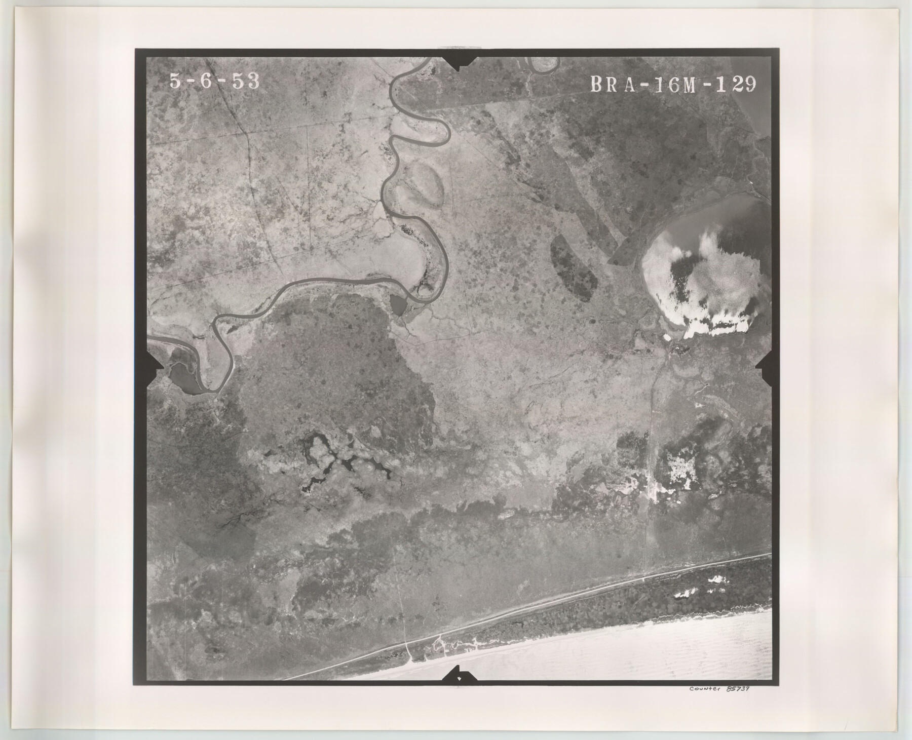
Flight Mission No. BRA-16M, Frame 129, Jefferson County
BRA-16M-129
-
Map/Doc
85739
-
Collection
General Map Collection
-
Object Dates
1953/5/6 (Creation Date)
-
People and Organizations
U. S. Department of Agriculture (Publisher)
-
Counties
Jefferson
-
Subjects
Aerial Photograph
-
Height x Width
18.4 x 22.7 inches
46.7 x 57.7 cm
-
Comments
Flown by Jack Ammann Photogrammetric Engineers of San Antonio, Texas.
Part of: General Map Collection
Martin County Working Sketch 10

Print $40.00
- Digital $50.00
Martin County Working Sketch 10
1971
Size 50.0 x 37.4 inches
Map/Doc 70828
Brewster County Rolled Sketch 79

Print $20.00
- Digital $50.00
Brewster County Rolled Sketch 79
Size 36.9 x 28.0 inches
Map/Doc 5244
Map of Haskell County

Print $20.00
- Digital $50.00
Map of Haskell County
1899
Size 40.1 x 35.3 inches
Map/Doc 16847
Jackson County Sketch File A2 (1)

Print $20.00
- Digital $50.00
Jackson County Sketch File A2 (1)
1899
Size 18.2 x 22.5 inches
Map/Doc 11848
El Paso County Sketch File 22

Print $22.00
- Digital $50.00
El Paso County Sketch File 22
1888
Size 14.2 x 9.0 inches
Map/Doc 22031
Flight Mission No. DIX-8P, Frame 75, Aransas County

Print $20.00
- Digital $50.00
Flight Mission No. DIX-8P, Frame 75, Aransas County
1956
Size 18.9 x 22.3 inches
Map/Doc 83906
Andrews County Working Sketch 13

Print $20.00
- Digital $50.00
Andrews County Working Sketch 13
1956
Size 37.3 x 30.6 inches
Map/Doc 67059
Texas-Louisiana Gulf Coastal Region showing Oil & Gas Fields & Prospects, Pipe Lines, Refineries & Principal Highways

Print $20.00
- Digital $50.00
Texas-Louisiana Gulf Coastal Region showing Oil & Gas Fields & Prospects, Pipe Lines, Refineries & Principal Highways
Size 22.4 x 44.2 inches
Map/Doc 96874
Webb County Sketch File 50

Print $20.00
- Digital $50.00
Webb County Sketch File 50
1939
Size 27.4 x 18.6 inches
Map/Doc 12648
Comanche County Rolled Sketch 2

Print $40.00
- Digital $50.00
Comanche County Rolled Sketch 2
1989
Size 36.9 x 48.6 inches
Map/Doc 10299
Uvalde County Working Sketch 54

Print $20.00
- Digital $50.00
Uvalde County Working Sketch 54
1983
Size 39.6 x 32.3 inches
Map/Doc 72124
Wharton County Sketch File 1

Print $6.00
- Digital $50.00
Wharton County Sketch File 1
Size 10.6 x 8.7 inches
Map/Doc 39910
You may also like
Kimble County Working Sketch 45

Print $20.00
- Digital $50.00
Kimble County Working Sketch 45
1950
Size 26.4 x 28.5 inches
Map/Doc 70113
Navarro County Sketch File 21

Print $4.00
- Digital $50.00
Navarro County Sketch File 21
1859
Size 9.0 x 8.4 inches
Map/Doc 32350
[Sketch of Berry Doolittle, C. B. Emmons. R. D. Price and other surveys]
![90213, [Sketch of Berry Doolittle, C. B. Emmons. R. D. Price and other surveys], Twichell Survey Records](https://historictexasmaps.com/wmedia_w700/maps/90213-1.tif.jpg)
Print $20.00
- Digital $50.00
[Sketch of Berry Doolittle, C. B. Emmons. R. D. Price and other surveys]
Size 25.8 x 19.7 inches
Map/Doc 90213
The Peters Colony. August 30, 1841

Print $20.00
The Peters Colony. August 30, 1841
2020
Size 21.7 x 21.7 inches
Map/Doc 96362
Reconnaissance Map, Roby Sheet

Print $20.00
- Digital $50.00
Reconnaissance Map, Roby Sheet
1893
Size 17.0 x 20.8 inches
Map/Doc 90869
Hunt County Working Sketch 2

Print $20.00
- Digital $50.00
Hunt County Working Sketch 2
Size 20.5 x 16.5 inches
Map/Doc 66349
Flight Mission No. CUG-2P, Frame 24, Kleberg County

Print $20.00
- Digital $50.00
Flight Mission No. CUG-2P, Frame 24, Kleberg County
1956
Size 18.4 x 22.3 inches
Map/Doc 86188
Hood County Working Sketch 20

Print $20.00
- Digital $50.00
Hood County Working Sketch 20
1989
Size 39.6 x 34.7 inches
Map/Doc 66214
Medina County Working Sketch 3

Print $40.00
- Digital $50.00
Medina County Working Sketch 3
1945
Size 52.6 x 37.1 inches
Map/Doc 70918
Galveston to Rio Grande

Print $20.00
- Digital $50.00
Galveston to Rio Grande
1946
Size 44.6 x 36.6 inches
Map/Doc 69952
Montague County Working Sketch 33

Print $20.00
- Digital $50.00
Montague County Working Sketch 33
1976
Size 30.6 x 43.3 inches
Map/Doc 71099
Harris County Sketch File 33a

Print $20.00
- Digital $50.00
Harris County Sketch File 33a
Size 34.1 x 30.0 inches
Map/Doc 10478