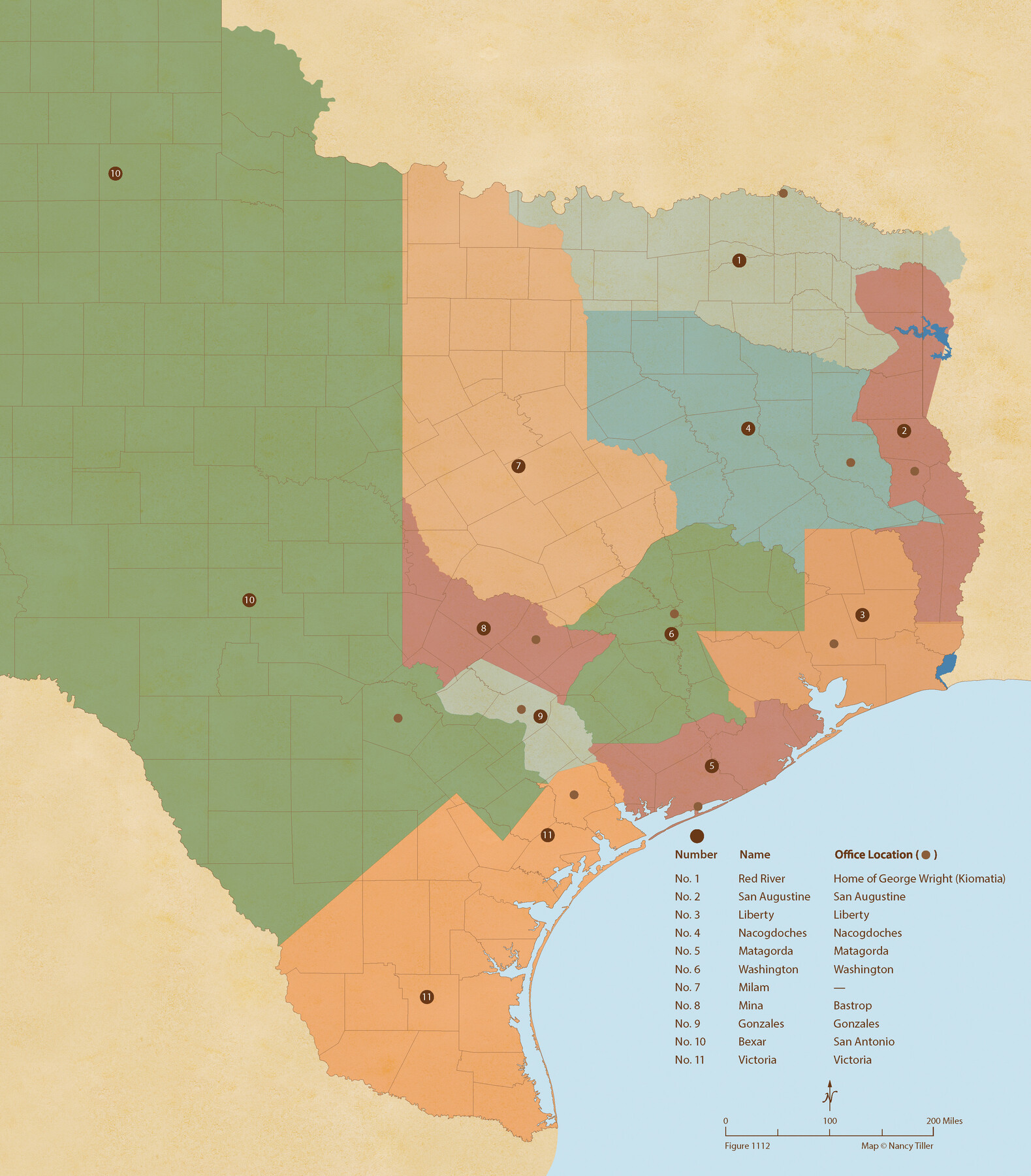
The Land Offices. December 22, 1836
Figure No. 1112 from 'A Boundary Atlas of Texas, 1821-1845' by Jim Tiller
-
Map/Doc
96425
-
Collection
Nancy and Jim Tiller Digital Collection
-
Object Dates
2020/1/1 (Creation Date)
-
People and Organizations
Jim Tiller (Author)
Nancy Tiller (Cartographer)
Gang Gong (GIS Professional)
-
Subjects
Atlas Republic of Texas Texas Boundaries
-
Height x Width
24.7 x 21.7 inches
62.7 x 55.1 cm
-
Medium
digital image
-
Comments
To purchase a digital PDF copy of "A Boundary Atlas of Texas, 1821-1845" see 96437.
Part of: Nancy and Jim Tiller Digital Collection
Republic Counties. January 1, 1844

Print $20.00
Republic Counties. January 1, 1844
2020
Size 24.5 x 21.7 inches
Map/Doc 96317
The Mexican Municipality of Matagorda. December 28, 1834

Print $20.00
The Mexican Municipality of Matagorda. December 28, 1834
2020
Size 15.9 x 21.7 inches
Map/Doc 96026
The Judicial District/County of Trinity. Abolished, Spring 1842

Print $20.00
The Judicial District/County of Trinity. Abolished, Spring 1842
2020
Size 14.7 x 21.7 inches
Map/Doc 96351
The Republic County of Colorado. 1840

Print $20.00
The Republic County of Colorado. 1840
2020
Size 18.4 x 21.7 inches
Map/Doc 96122
The Chief Justice County of Goliad. Proposed, No Date

Print $20.00
The Chief Justice County of Goliad. Proposed, No Date
2020
Size 14.7 x 21.7 inches
Map/Doc 96046
The Republic County of Galveston. December 16, 1839

Print $20.00
The Republic County of Galveston. December 16, 1839
2020
Size 14.7 x 21.9 inches
Map/Doc 96144
The Judicial District/County of Menard. Created, January 22, 1841

Print $20.00
The Judicial District/County of Menard. Created, January 22, 1841
2020
Size 22.4 x 21.7 inches
Map/Doc 96335
The Republic County of Bowie. Created, December 17, 1840

Print $20.00
The Republic County of Bowie. Created, December 17, 1840
2020
Size 19.5 x 21.7 inches
Map/Doc 96102
The Chief Justice County of Harrisburg. January 30, 1837

Print $20.00
The Chief Justice County of Harrisburg. January 30, 1837
2020
Size 17.5 x 21.7 inches
Map/Doc 96049
The Mexican Department of Nacogdoches. May 6, 1833

Print $20.00
The Mexican Department of Nacogdoches. May 6, 1833
2020
Size 18.5 x 21.7 inches
Map/Doc 95973
The Mexican Municipality of San Augustine. Created March 6, 1834

Print $20.00
The Mexican Municipality of San Augustine. Created March 6, 1834
2020
Size 24.1 x 21.7 inches
Map/Doc 96032
The Judicial District/County of Panola. June 24, 1841

Print $20.00
The Judicial District/County of Panola. June 24, 1841
2020
Size 19.3 x 21.7 inches
Map/Doc 96341
You may also like
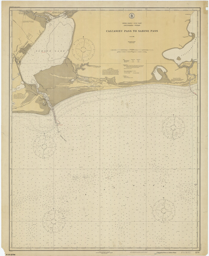
Calcasieu Pass to Sabine Pass
Print $20.00
- Digital $50.00
Calcasieu Pass to Sabine Pass
1925
Size 44.1 x 36.0 inches
Map/Doc 69804
Young County Rolled Sketch 18

Print $20.00
- Digital $50.00
Young County Rolled Sketch 18
2020
Size 22.6 x 30.4 inches
Map/Doc 95960
Cottle County Sketch File 15

Print $4.00
- Digital $50.00
Cottle County Sketch File 15
1891
Size 11.2 x 9.0 inches
Map/Doc 19516
Rand McNally Main Highway Map of Texas

Print $20.00
Rand McNally Main Highway Map of Texas
1923
Size 27.7 x 40.3 inches
Map/Doc 76260
Flight Mission No. DQN-6K, Frame 71, Calhoun County

Print $20.00
- Digital $50.00
Flight Mission No. DQN-6K, Frame 71, Calhoun County
1953
Size 18.5 x 22.2 inches
Map/Doc 84443
Texas - Official Highway Travel Map

Texas - Official Highway Travel Map
Size 27.4 x 36.4 inches
Map/Doc 94299
Working Sketch in Gray, Donley, and Carson Counties, Texas

Print $20.00
- Digital $50.00
Working Sketch in Gray, Donley, and Carson Counties, Texas
1909
Size 22.7 x 27.0 inches
Map/Doc 90779
Coleman County Sketch File 44

Print $17.00
- Digital $50.00
Coleman County Sketch File 44
Size 14.1 x 8.6 inches
Map/Doc 18783
Kleberg County Boundary File 1

Print $10.00
- Digital $50.00
Kleberg County Boundary File 1
Size 9.3 x 5.9 inches
Map/Doc 64961
Brazoria County Sketch File 9

Print $6.00
- Digital $50.00
Brazoria County Sketch File 9
Size 14.0 x 9.0 inches
Map/Doc 14936
Plano del Presidio de Bahia dela Espiritu Santo dependite dela Governacion de los Tejas situado en 29 grad. Y 39 min. de latitud boreal y 277° y 54' dela long. contados desde el Merid. De Tenerife

Plano del Presidio de Bahia dela Espiritu Santo dependite dela Governacion de los Tejas situado en 29 grad. Y 39 min. de latitud boreal y 277° y 54' dela long. contados desde el Merid. De Tenerife
1768
Size 16.7 x 21.0 inches
Map/Doc 96565
Limestone County Sketch File 24

Print $8.00
- Digital $50.00
Limestone County Sketch File 24
1942
Size 11.2 x 8.8 inches
Map/Doc 30206