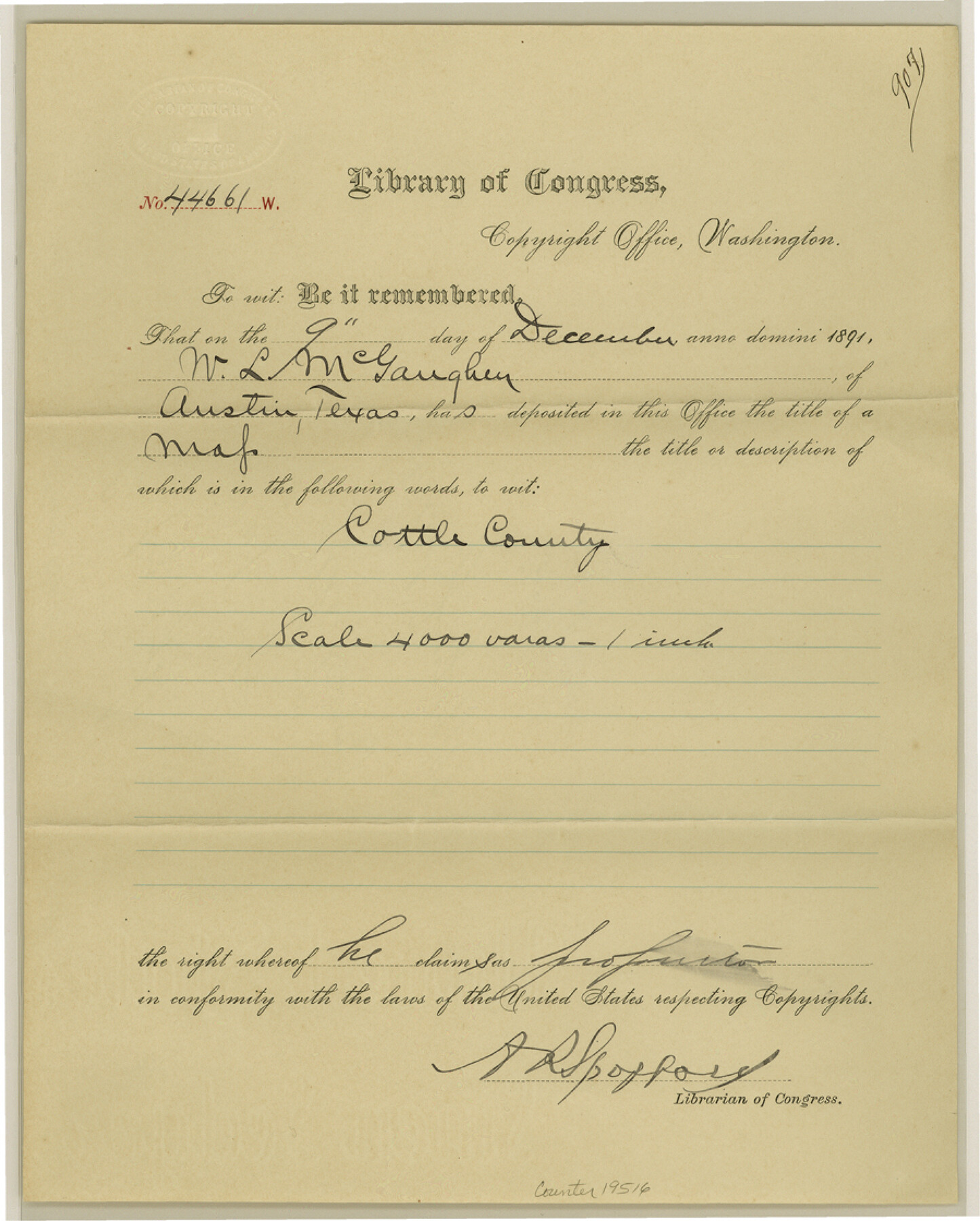
Cottle County Sketch File 15
[Certificate of copyright from Library of Congress for Cottle County Map]
-
Map/Doc
19516
-
Collection
General Map Collection
-
Object Dates
1891/12/9 (Creation Date)
1892/1/19 (File Date)
-
People and Organizations
Wm. Bramlette (GLO Clerk)
-
Counties
Cottle
-
Subjects
Surveying Sketch File
-
Height x Width
11.2 x 9.0 inches
28.4 x 22.9 cm
-
Medium
paper, manuscript
-
Scale
1:4000
Part of: General Map Collection
Upton County Sketch File R

Print $4.00
- Digital $50.00
Upton County Sketch File R
Size 13.4 x 8.8 inches
Map/Doc 38848
Reeves County Working Sketch 26

Print $20.00
- Digital $50.00
Reeves County Working Sketch 26
1967
Size 44.5 x 36.0 inches
Map/Doc 63469
McLennan County Working Sketch Graphic Index

Print $20.00
- Digital $50.00
McLennan County Working Sketch Graphic Index
1946
Size 41.8 x 44.8 inches
Map/Doc 76637
Travis County Sketch File 46

Print $20.00
- Digital $50.00
Travis County Sketch File 46
1939
Size 21.0 x 21.2 inches
Map/Doc 12468
Brown County Rolled Sketch 1

Print $20.00
- Digital $50.00
Brown County Rolled Sketch 1
1969
Size 15.4 x 22.1 inches
Map/Doc 5348
Fort Bend County Sketch File 27

Print $20.00
- Digital $50.00
Fort Bend County Sketch File 27
1910
Size 17.9 x 37.7 inches
Map/Doc 10453
Aransas County Working Sketch 20

Print $20.00
- Digital $50.00
Aransas County Working Sketch 20
1980
Size 11.9 x 24.4 inches
Map/Doc 67187

[Capitol lands granted for purpose of building State Capitol]
![2073, [Capitol lands granted for purpose of building State Capitol], General Map Collection](https://historictexasmaps.com/wmedia_w700/maps/2073.tif.jpg)
Print $20.00
- Digital $50.00
[Capitol lands granted for purpose of building State Capitol]
1956
Size 31.5 x 13.0 inches
Map/Doc 2073
Liberty County Working Sketch 51

Print $20.00
- Digital $50.00
Liberty County Working Sketch 51
1955
Size 17.5 x 38.5 inches
Map/Doc 70511
Flight Mission No. BRA-6M, Frame 148, Jefferson County

Print $20.00
- Digital $50.00
Flight Mission No. BRA-6M, Frame 148, Jefferson County
1953
Size 18.5 x 22.4 inches
Map/Doc 85449
Kimble County Working Sketch 78

Print $20.00
- Digital $50.00
Kimble County Working Sketch 78
1970
Size 46.0 x 31.6 inches
Map/Doc 70146
You may also like
La Salle County Working Sketch 54

Print $20.00
- Digital $50.00
La Salle County Working Sketch 54
2009
Size 23.2 x 46.2 inches
Map/Doc 89048
Randall County Sketch File 10

Print $4.00
- Digital $50.00
Randall County Sketch File 10
1941
Size 11.4 x 8.8 inches
Map/Doc 34972
Reagan County Sketch File 15

Print $4.00
- Digital $50.00
Reagan County Sketch File 15
1931
Size 8.0 x 13.3 inches
Map/Doc 35000
Brewster County Working Sketch 91

Print $40.00
- Digital $50.00
Brewster County Working Sketch 91
1975
Size 65.7 x 43.6 inches
Map/Doc 67691
El Paso County Sketch File 35 (3)

Print $40.00
- Digital $50.00
El Paso County Sketch File 35 (3)
1886
Size 12.8 x 8.3 inches
Map/Doc 22179
Crockett County Sketch File 44

Print $8.00
- Digital $50.00
Crockett County Sketch File 44
1881
Size 12.8 x 8.8 inches
Map/Doc 19768
Flight Mission No. BQR-9K, Frame 50, Brazoria County

Print $20.00
- Digital $50.00
Flight Mission No. BQR-9K, Frame 50, Brazoria County
1952
Size 18.7 x 22.4 inches
Map/Doc 84054
Real County Working Sketch 36

Print $20.00
- Digital $50.00
Real County Working Sketch 36
1950
Size 24.7 x 35.9 inches
Map/Doc 71928
Sherman County Sketch File 7

Print $2.00
- Digital $50.00
Sherman County Sketch File 7
1993
Size 14.6 x 9.0 inches
Map/Doc 36725
Hudspeth County Working Sketch 26

Print $40.00
- Digital $50.00
Hudspeth County Working Sketch 26
1972
Size 31.5 x 54.0 inches
Map/Doc 66308
Sketch X, Hardin County

Print $20.00
- Digital $50.00
Sketch X, Hardin County
1904
Size 26.3 x 38.1 inches
Map/Doc 75823
Kinney County Working Sketch 10

Print $20.00
- Digital $50.00
Kinney County Working Sketch 10
1933
Size 23.1 x 18.4 inches
Map/Doc 70192