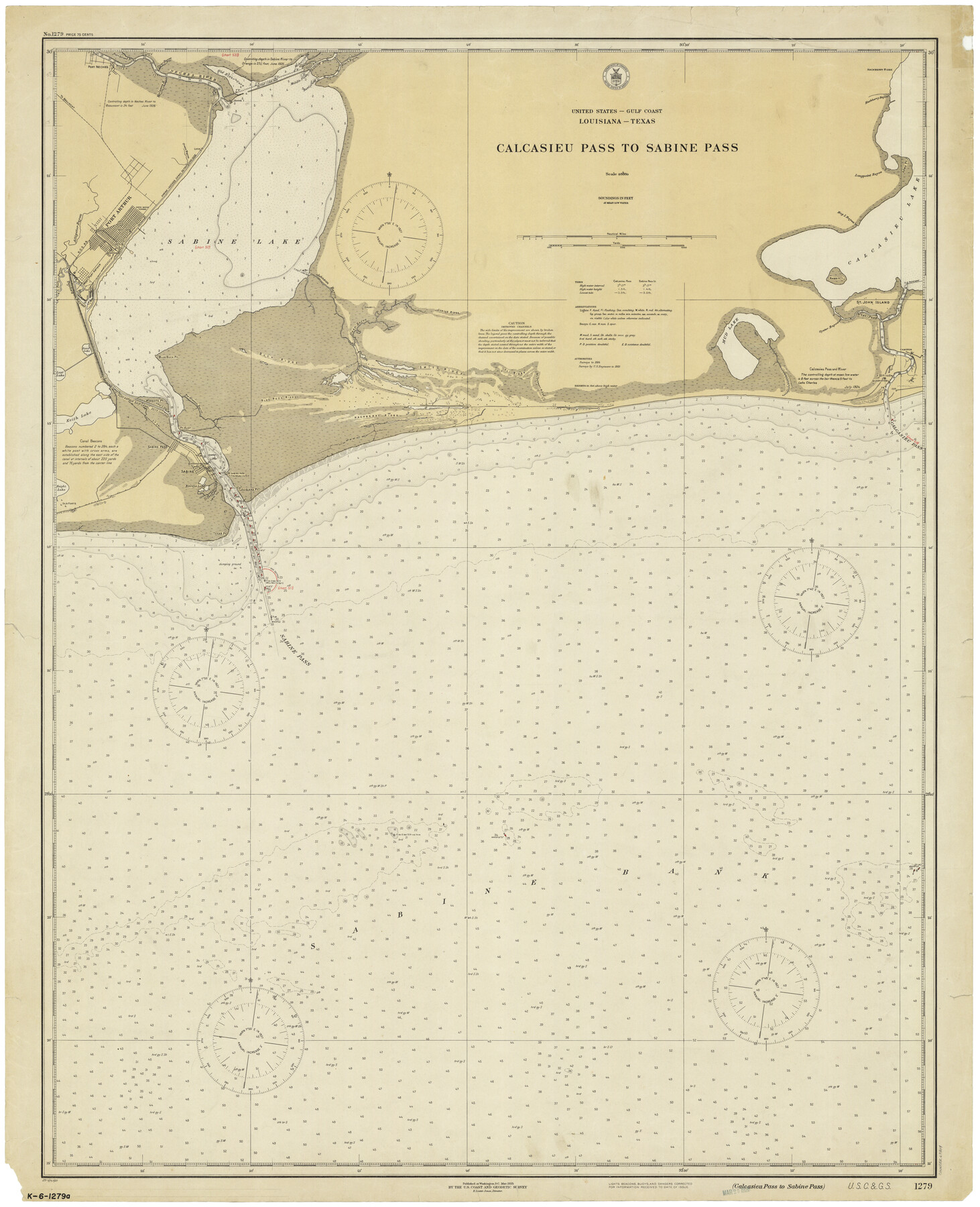
Calcasieu Pass to Sabine Pass
K-6-1279a
-
Map/Doc
69804
-
Collection
General Map Collection
-
Object Dates
3/1925 (Creation Date)
-
Counties
Jefferson Orange
-
Subjects
Nautical Charts
-
Height x Width
44.1 x 36.0 inches
112.0 x 91.4 cm
Part of: General Map Collection
Matagorda County NRC Article 33.136 Sketch 9

Print $28.00
- Digital $50.00
Matagorda County NRC Article 33.136 Sketch 9
2011
Size 24.0 x 36.0 inches
Map/Doc 94811
Map of Nacogdoches County

Print $20.00
- Digital $50.00
Map of Nacogdoches County
1881
Size 24.1 x 21.5 inches
Map/Doc 4605
Duval County Sketch File 66

Print $12.00
- Digital $50.00
Duval County Sketch File 66
1944
Size 14.5 x 8.8 inches
Map/Doc 21444
[Sketch for Mineral Application 16700 - Pecos River Bed]
![2808, [Sketch for Mineral Application 16700 - Pecos River Bed], General Map Collection](https://historictexasmaps.com/wmedia_w700/maps/2808.tif.jpg)
Print $20.00
- Digital $50.00
[Sketch for Mineral Application 16700 - Pecos River Bed]
1927
Size 19.9 x 30.9 inches
Map/Doc 2808
Portion of States Submerged Area in Matagorda Bay

Print $20.00
- Digital $50.00
Portion of States Submerged Area in Matagorda Bay
1923
Size 12.7 x 13.5 inches
Map/Doc 2956
Hockley County

Print $20.00
- Digital $50.00
Hockley County
1900
Size 41.5 x 36.7 inches
Map/Doc 16852
Edwards County Working Sketch 97

Print $20.00
- Digital $50.00
Edwards County Working Sketch 97
1969
Size 25.5 x 27.6 inches
Map/Doc 68973
Flight Mission No. CUG-3P, Frame 189, Kleberg County

Print $20.00
- Digital $50.00
Flight Mission No. CUG-3P, Frame 189, Kleberg County
1956
Size 18.6 x 22.2 inches
Map/Doc 86293
Hamilton County Sketch File 14

Print $10.00
- Digital $50.00
Hamilton County Sketch File 14
Size 10.1 x 8.0 inches
Map/Doc 24937
Tyler County Sketch File 3a

Print $4.00
- Digital $50.00
Tyler County Sketch File 3a
1857
Size 6.2 x 8.2 inches
Map/Doc 38626
Pecos County Sketch File 110

Print $22.00
- Digital $50.00
Pecos County Sketch File 110
1913
Size 12.9 x 8.8 inches
Map/Doc 34041
Crosby County Sketch File 34

Print $4.00
- Digital $50.00
Crosby County Sketch File 34
1892
Size 11.3 x 8.9 inches
Map/Doc 20104
You may also like
Flight Mission No. DQO-3K, Frame 19, Galveston County

Print $20.00
- Digital $50.00
Flight Mission No. DQO-3K, Frame 19, Galveston County
1952
Size 18.7 x 22.5 inches
Map/Doc 85060
Zavala County Sketch File 9

Print $20.00
- Digital $50.00
Zavala County Sketch File 9
1884
Size 29.1 x 15.9 inches
Map/Doc 12727
[Jas. T. Williams Survey and vicinity]
![91264, [Jas. T. Williams Survey and vicinity], Twichell Survey Records](https://historictexasmaps.com/wmedia_w700/maps/91264-1.tif.jpg)
Print $20.00
- Digital $50.00
[Jas. T. Williams Survey and vicinity]
Size 15.0 x 12.0 inches
Map/Doc 91264
McCulloch County Sketch File 2

Print $4.00
- Digital $50.00
McCulloch County Sketch File 2
1872
Size 12.8 x 8.1 inches
Map/Doc 31167
Angelina County Working Sketch 33

Print $20.00
- Digital $50.00
Angelina County Working Sketch 33
1955
Size 22.7 x 24.2 inches
Map/Doc 67116
Floyd County Boundary File 4

Print $4.00
- Digital $50.00
Floyd County Boundary File 4
Size 11.2 x 8.9 inches
Map/Doc 53494
Map of Robertson Co.

Print $20.00
- Digital $50.00
Map of Robertson Co.
1889
Size 44.0 x 39.1 inches
Map/Doc 3996
Kinney County Working Sketch 58

Print $20.00
- Digital $50.00
Kinney County Working Sketch 58
1996
Size 36.1 x 31.7 inches
Map/Doc 70240
Pecos County Rolled Sketch DK2

Print $20.00
- Digital $50.00
Pecos County Rolled Sketch DK2
1938
Size 31.8 x 40.0 inches
Map/Doc 9714
Map showing the Distribution of Slaves in the Southern States

Print $20.00
- Digital $50.00
Map showing the Distribution of Slaves in the Southern States
1861
Size 15.2 x 18.3 inches
Map/Doc 96634
Texas Gulf Coast, from the Sabine River to the Rio Grande as Subdivided for Mineral Development; Matagorda, Calhoun and Aransas Counties

Print $40.00
- Digital $50.00
Texas Gulf Coast, from the Sabine River to the Rio Grande as Subdivided for Mineral Development; Matagorda, Calhoun and Aransas Counties
1976
Size 43.0 x 90.9 inches
Map/Doc 1939
Real County Working Sketch 33

Print $40.00
- Digital $50.00
Real County Working Sketch 33
1948
Size 61.0 x 37.7 inches
Map/Doc 71925