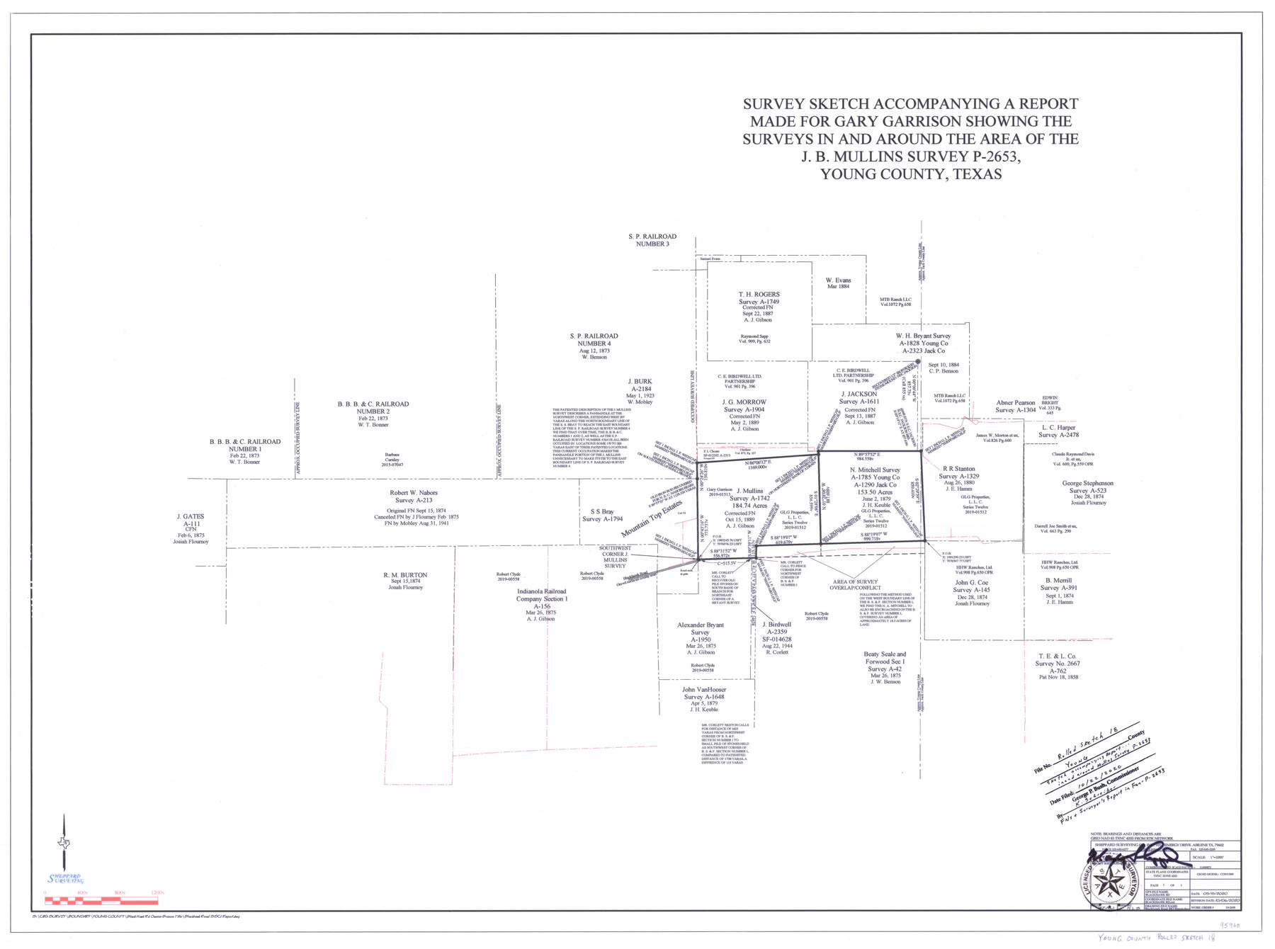
Young County Rolled Sketch 18
Survey sketch accompanying a report made for Gary Garrison showing the surveys in and around the area of the J.B. Mullins survey P-2653, Young County, Texas
-
Map/Doc
95960
-
Collection
General Map Collection
-
Object Dates
2020/5/15 (Creation Date)
2020/10/6 (Revision Date)
2020/10/22 (File Date)
-
People and Organizations
Maxey Sheppard (Surveyor/Engineer)
-
Counties
Young Jack
-
Subjects
Surveying Rolled Sketch
-
Height x Width
22.6 x 30.4 inches
57.4 x 77.2 cm
-
Medium
mylar, print
-
Scale
1" = 1000 feet
-
Comments
Field notes and surveyor's report in FAN P-2653.
Part of: General Map Collection
Flight Mission No. BRA-8M, Frame 131, Jefferson County

Print $20.00
- Digital $50.00
Flight Mission No. BRA-8M, Frame 131, Jefferson County
1953
Size 15.9 x 16.0 inches
Map/Doc 85627
Cottle County Sketch File 16a

Print $64.00
- Digital $50.00
Cottle County Sketch File 16a
1911
Size 11.5 x 8.9 inches
Map/Doc 19522
Val Verde County Rolled Sketch 79

Print $20.00
- Digital $50.00
Val Verde County Rolled Sketch 79
1983
Size 25.6 x 21.7 inches
Map/Doc 8141
Map of the Houston & Great Northern Railroad

Print $40.00
- Digital $50.00
Map of the Houston & Great Northern Railroad
1871
Size 29.3 x 122.1 inches
Map/Doc 64551
Real County Working Sketch 68

Print $20.00
- Digital $50.00
Real County Working Sketch 68
1973
Size 21.9 x 24.4 inches
Map/Doc 71960
Montague County Sketch File 2

Print $24.00
- Digital $50.00
Montague County Sketch File 2
1856
Size 12.0 x 8.5 inches
Map/Doc 31711
Dimmit County Sketch File 20 1/2

Print $43.00
- Digital $50.00
Dimmit County Sketch File 20 1/2
Size 9.0 x 8.6 inches
Map/Doc 21104
Clay County Sketch File 10

Print $4.00
- Digital $50.00
Clay County Sketch File 10
1860
Size 8.8 x 7.6 inches
Map/Doc 18406
Flight Mission No. CRK-7P, Frame 133, Refugio County

Print $20.00
- Digital $50.00
Flight Mission No. CRK-7P, Frame 133, Refugio County
1956
Size 18.3 x 22.1 inches
Map/Doc 86956

Township 6 North Range 13 West, North Western District, Louisiana

Print $20.00
- Digital $50.00
Township 6 North Range 13 West, North Western District, Louisiana
1841
Size 19.7 x 24.8 inches
Map/Doc 65864
El Paso County Sketch File 39

Print $27.00
- Digital $50.00
El Paso County Sketch File 39
1922
Size 13.9 x 8.8 inches
Map/Doc 22225
You may also like
Flight Mission No. BRE-2P, Frame 106, Nueces County

Print $20.00
- Digital $50.00
Flight Mission No. BRE-2P, Frame 106, Nueces County
1956
Size 18.7 x 22.8 inches
Map/Doc 86791
Pecos County Working Sketch 104

Print $40.00
- Digital $50.00
Pecos County Working Sketch 104
1971
Size 63.1 x 26.9 inches
Map/Doc 71577
Freestone County Working Sketch 16

Print $20.00
- Digital $50.00
Freestone County Working Sketch 16
1980
Size 47.1 x 39.7 inches
Map/Doc 69258
General Highway Map, San Jacinto County, Texas

Print $20.00
General Highway Map, San Jacinto County, Texas
1940
Size 24.9 x 18.4 inches
Map/Doc 79236
[Area between G. C. & S. F. RR. Co. Block 194 and Runnels County School Land Survey No. 3]
![91635, [Area between G. C. & S. F. RR. Co. Block 194 and Runnels County School Land Survey No. 3], Twichell Survey Records](https://historictexasmaps.com/wmedia_w700/maps/91635-1.tif.jpg)
Print $3.00
- Digital $50.00
[Area between G. C. & S. F. RR. Co. Block 194 and Runnels County School Land Survey No. 3]
1926
Size 16.6 x 11.9 inches
Map/Doc 91635
Phelps and Watson's Historical and Military Map of the Border and Southern States

Print $20.00
Phelps and Watson's Historical and Military Map of the Border and Southern States
1863
Size 25.5 x 36.3 inches
Map/Doc 76202
Rusk County Sketch File 42

Print $6.00
Rusk County Sketch File 42
1951
Size 11.5 x 8.9 inches
Map/Doc 35582
County School Lands

Print $3.00
- Digital $50.00
County School Lands
1913
Size 10.4 x 14.2 inches
Map/Doc 90450
Runnels County Working Sketch 4

Print $20.00
- Digital $50.00
Runnels County Working Sketch 4
1906
Size 15.1 x 19.3 inches
Map/Doc 63600
Map of Independence Area, Washington County, Texas

Print $20.00
- Digital $50.00
Map of Independence Area, Washington County, Texas
1935
Size 28.9 x 26.0 inches
Map/Doc 91990
Current Miscellaneous File 4

Print $8.00
- Digital $50.00
Current Miscellaneous File 4
1947
Size 11.5 x 9.1 inches
Map/Doc 73723
Menard County Sketch File 16

Print $6.00
- Digital $50.00
Menard County Sketch File 16
1892
Size 12.8 x 8.4 inches
Map/Doc 31513