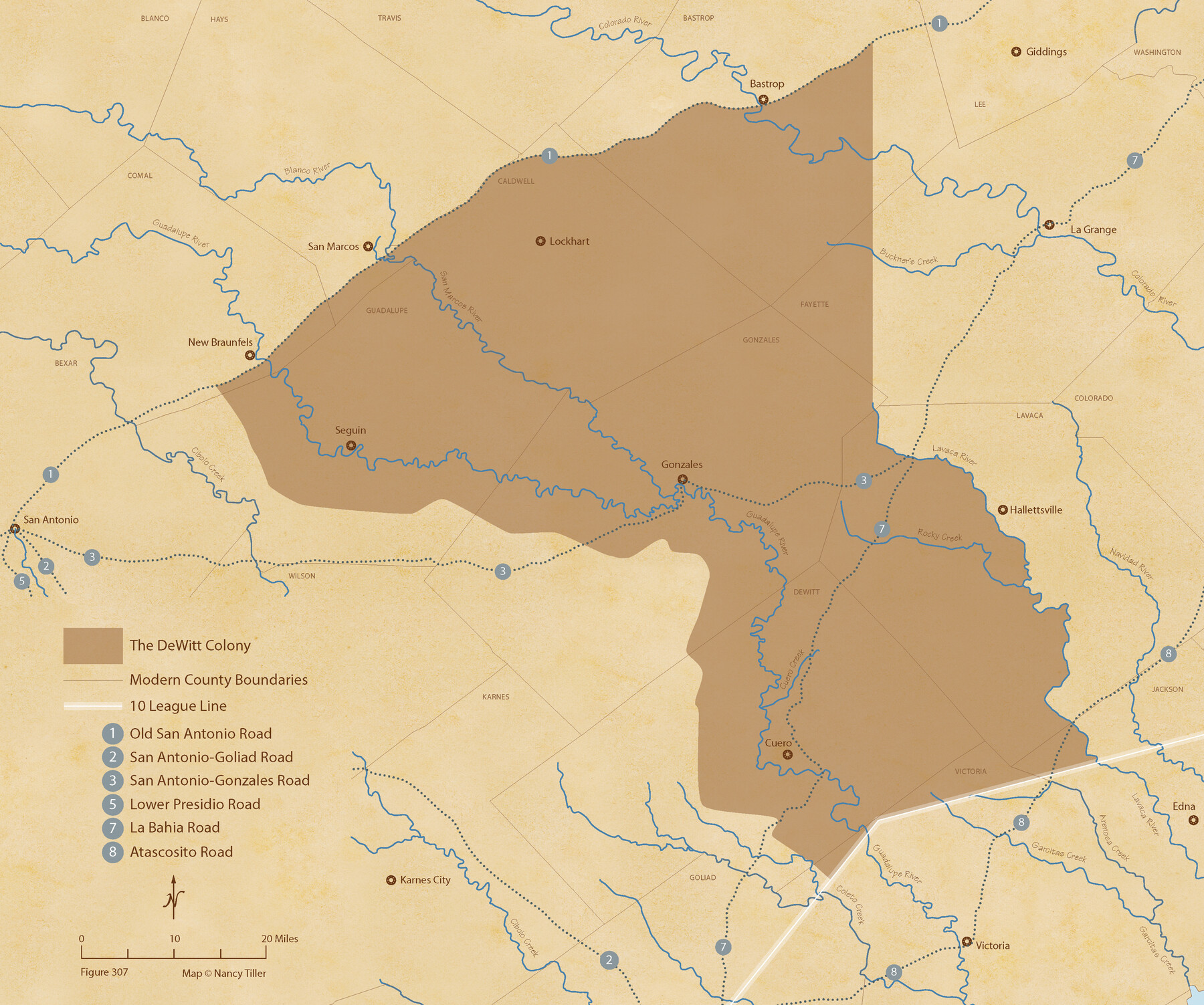
DeWitt Empresario Colony. April 15, 1825
Figure No. 307 from 'A Boundary Atlas of Texas, 1821-1845' by Jim Tiller
-
Map/Doc
95991
-
Collection
Nancy and Jim Tiller Digital Collection
-
Object Dates
2020/1/1 (Creation Date)
-
People and Organizations
Jim Tiller (Author)
Nancy Tiller (Cartographer)
Gang Gong (GIS Professional)
-
Subjects
Atlas Colony Mexican Texas Texas Boundaries
-
Height x Width
18.1 x 21.7 inches
46.0 x 55.1 cm
-
Medium
digital image
-
Comments
To purchase a digital PDF copy of "A Boundary Atlas of Texas, 1821-1845" see 96437.
Part of: Nancy and Jim Tiller Digital Collection
Thorn Empresario Colony. April 25, 1825

Print $20.00
Thorn Empresario Colony. April 25, 1825
2020
Size 17.0 x 21.7 inches
Map/Doc 96006
Austin Empresario Colony. January 17, 1821/February 18, 1823

Print $20.00
Austin Empresario Colony. January 17, 1821/February 18, 1823
2020
Size 18.8 x 21.6 inches
Map/Doc 95978
The Chief Justice County of Jackson. April 24, 1837

Print $20.00
The Chief Justice County of Jackson. April 24, 1837
2020
Size 18.4 x 21.7 inches
Map/Doc 96051
The Republic County of Jasper. Boundaries Defined, December 14, 1837

Print $20.00
The Republic County of Jasper. Boundaries Defined, December 14, 1837
2020
Size 19.5 x 21.7 inches
Map/Doc 96193
The Republic County of Matagorda. December 29, 1845

Print $20.00
The Republic County of Matagorda. December 29, 1845
2020
Size 21.0 x 21.7 inches
Map/Doc 96224
Austin Empresario Colony. February 25, 1831

Print $20.00
Austin Empresario Colony. February 25, 1831
2020
Size 17.0 x 21.7 inches
Map/Doc 95983
The Peters Colony. November 9, 1841

Print $20.00
The Peters Colony. November 9, 1841
2020
Size 21.7 x 21.7 inches
Map/Doc 96363
The Castro Colony. February 15, 1842

Print $20.00
The Castro Colony. February 15, 1842
2020
Size 23.0 x 17.7 inches
Map/Doc 96357
The Republic County of Bowie. January 16, 1843

Print $20.00
The Republic County of Bowie. January 16, 1843
2020
Size 19.5 x 21.7 inches
Map/Doc 96106
The Mexican Municipalities. On the Eve of Texas Independence, 1836

Print $20.00
The Mexican Municipalities. On the Eve of Texas Independence, 1836
2020
Size 17.2 x 21.6 inches
Map/Doc 96013
The Republic County of Montgomery. December 29, 1845

Print $20.00
The Republic County of Montgomery. December 29, 1845
2020
Size 19.9 x 21.7 inches
Map/Doc 96241
The Coastal and Border League Lines

Print $20.00
The Coastal and Border League Lines
2020
Size 20.2 x 21.6 inches
Map/Doc 95977
You may also like
Floyd County Rolled Sketch 4

Print $20.00
- Digital $50.00
Floyd County Rolled Sketch 4
1917
Size 22.8 x 33.8 inches
Map/Doc 5879
Crockett County Rolled Sketch 67

Print $20.00
- Digital $50.00
Crockett County Rolled Sketch 67
1948
Size 34.2 x 21.7 inches
Map/Doc 5610
Galveston County

Print $20.00
- Digital $50.00
Galveston County
1860
Size 20.2 x 31.4 inches
Map/Doc 3575
Comal County Sketch File 18

Print $4.00
- Digital $50.00
Comal County Sketch File 18
Size 6.7 x 13.0 inches
Map/Doc 19037
Crosby County Sketch File 14a

Print $40.00
- Digital $50.00
Crosby County Sketch File 14a
Size 18.9 x 20.5 inches
Map/Doc 11249
Flight Mission No. DCL-5C, Frame 50, Kenedy County

Print $20.00
- Digital $50.00
Flight Mission No. DCL-5C, Frame 50, Kenedy County
1943
Size 18.6 x 22.4 inches
Map/Doc 85846
A Geographically Correct County Map of States Traversed by the St. Louis, Iron Mountain and Southern Railway and its connections

Print $20.00
- Digital $50.00
A Geographically Correct County Map of States Traversed by the St. Louis, Iron Mountain and Southern Railway and its connections
1878
Size 16.9 x 27.0 inches
Map/Doc 95785
Drainage Basins of Texas Streams

Print $20.00
- Digital $50.00
Drainage Basins of Texas Streams
Size 17.0 x 19.3 inches
Map/Doc 65269
Photostat of section of hydrographic surveys H-5399, H-4822, H-470

Print $2.00
- Digital $50.00
Photostat of section of hydrographic surveys H-5399, H-4822, H-470
1933
Size 10.6 x 8.1 inches
Map/Doc 61159
Val Verde County Sketch File 40

Print $20.00
- Digital $50.00
Val Verde County Sketch File 40
1939
Size 15.3 x 25.5 inches
Map/Doc 12582
Preliminary Sketch of Galveston Bay Indicating Proposed Sites for Light Houses

Print $20.00
Preliminary Sketch of Galveston Bay Indicating Proposed Sites for Light Houses
1851
Size 20.7 x 18.0 inches
Map/Doc 76215
Coast of Texas and its defences

Print $20.00
- Digital $50.00
Coast of Texas and its defences
Size 27.6 x 18.2 inches
Map/Doc 72685