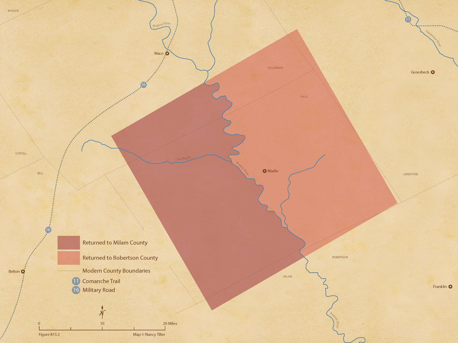
The Judicial District/County of Waco. Abolished, Spring 1842
Figure No. 815.2 from 'A Boundary Atlas of Texas, 1821-1845' by Jim Tiller
-
Map/Doc
96353
-
Collection
Nancy and Jim Tiller Digital Collection
-
Object Dates
2020/1/1 (Creation Date)
-
People and Organizations
Jim Tiller (Author)
Nancy Tiller (Cartographer)
Gang Gong (GIS Professional)
-
Subjects
Atlas Republic of Texas Texas Boundaries
-
Height x Width
16.2 x 21.7 inches
41.2 x 55.1 cm
-
Medium
digital image
-
Comments
To purchase a digital PDF copy of "A Boundary Atlas of Texas, 1821-1845" see 96437.
Part of: Nancy and Jim Tiller Digital Collection
The Republic County of Bastrop. December 29, 1845

Print $20.00
The Republic County of Bastrop. December 29, 1845
2020
Size 14.8 x 21.7 inches
Map/Doc 96092
Wavell Empresario Colony. Proposed, March 9, 1826

Print $20.00
Wavell Empresario Colony. Proposed, March 9, 1826
2020
Size 16.0 x 21.7 inches
Map/Doc 96009
The Chief Justice County of Austin. Proposed, No Date

Print $20.00
The Chief Justice County of Austin. Proposed, No Date
2020
Size 16.7 x 21.7 inches
Map/Doc 96037
The Judicial District/County of Ward. Abolished, Spring 1842

Print $20.00
The Judicial District/County of Ward. Abolished, Spring 1842
2020
Size 18.7 x 21.7 inches
Map/Doc 96355
The Republic County of Montgomery. December 29, 1845

Print $20.00
The Republic County of Montgomery. December 29, 1845
2020
Size 19.9 x 21.7 inches
Map/Doc 96241
From Citizens of Austin and Harris Counties Living in What Was to Become Fort Bend County for the Creation of a New County (Unnamed), Undated

Print $20.00
From Citizens of Austin and Harris Counties Living in What Was to Become Fort Bend County for the Creation of a New County (Unnamed), Undated
2020
Size 22.6 x 21.7 inches
Map/Doc 96399
The Republic County of Brazoria. January 20, 1841

Print $20.00
The Republic County of Brazoria. January 20, 1841
2020
Size 14.7 x 21.8 inches
Map/Doc 96114
The Republic County of Bexar. South View. Proposed, Fall 1837-December 31, 1838

Print $20.00
The Republic County of Bexar. South View. Proposed, Fall 1837-December 31, 1838
2020
Size 14.7 x 22.3 inches
Map/Doc 96095
The Republic County of Bastrop. January 25, 1840

Print $20.00
The Republic County of Bastrop. January 25, 1840
2020
Size 14.7 x 21.6 inches
Map/Doc 96091
The Republic County of Montgomery. December 31, 1838

Print $20.00
The Republic County of Montgomery. December 31, 1838
2020
Size 19.9 x 21.7 inches
Map/Doc 96236
The Republic County of Matagorda. December 24, 1844

Print $20.00
The Republic County of Matagorda. December 24, 1844
2020
Size 21.0 x 21.7 inches
Map/Doc 96223
The Judicial District/County of Hamilton. Created, February 2, 1842

Print $20.00
The Judicial District/County of Hamilton. Created, February 2, 1842
2020
Size 14.9 x 21.7 inches
Map/Doc 96329
You may also like
Flight Mission No. CUI-1H, Frame 140, Milam County

Print $20.00
- Digital $50.00
Flight Mission No. CUI-1H, Frame 140, Milam County
1951
Size 18.4 x 22.2 inches
Map/Doc 86606
Brewster County Working Sketch 70

Print $20.00
- Digital $50.00
Brewster County Working Sketch 70
1961
Size 30.5 x 44.0 inches
Map/Doc 67671

[Surveys in Austin's Colony along New Year's Creek and the Navidad River]
![212, [Surveys in Austin's Colony along New Year's Creek and the Navidad River], General Map Collection](https://historictexasmaps.com/wmedia_w700/maps/212.tif.jpg)
Print $20.00
- Digital $50.00
[Surveys in Austin's Colony along New Year's Creek and the Navidad River]
Size 20.2 x 15.6 inches
Map/Doc 212
Preliminary Sketch of Galveston Bay Indicating Proposed Sites for Light Houses

Print $20.00
Preliminary Sketch of Galveston Bay Indicating Proposed Sites for Light Houses
1851
Size 20.7 x 18.0 inches
Map/Doc 76215
Reeves County Working Sketch 45

Print $20.00
- Digital $50.00
Reeves County Working Sketch 45
1974
Size 46.9 x 32.3 inches
Map/Doc 63488
Terrell County Rolled Sketch 57

Print $20.00
- Digital $50.00
Terrell County Rolled Sketch 57
1986
Size 33.0 x 25.2 inches
Map/Doc 7974
El Paso County Rolled Sketch 61

Print $20.00
- Digital $50.00
El Paso County Rolled Sketch 61
1994
Size 27.8 x 39.0 inches
Map/Doc 5853
Refugio County Sketch File 21

Print $20.00
- Digital $50.00
Refugio County Sketch File 21
1933
Size 17.8 x 22.1 inches
Map/Doc 12248
Falls County Sketch File 11b

Print $4.00
- Digital $50.00
Falls County Sketch File 11b
1871
Size 10.4 x 8.5 inches
Map/Doc 22362
Hays County Sketch File 35

Print $4.00
- Digital $50.00
Hays County Sketch File 35
1873
Size 12.8 x 8.2 inches
Map/Doc 26277
Comanche County Sketch File 10

Print $4.00
- Digital $50.00
Comanche County Sketch File 10
1859
Size 8.4 x 16.0 inches
Map/Doc 19070