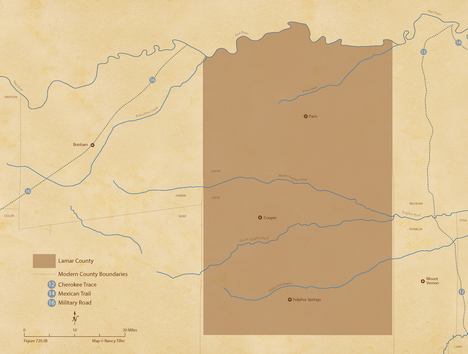
The Republic County of Lamar. Spring 1842
Figure No. 720.3 from 'A Boundary Atlas of Texas, 1821-1845' by Jim Tiller
-
Map/Doc
96204
-
Collection
Nancy and Jim Tiller Digital Collection
-
Object Dates
2020/1/1 (Creation Date)
-
People and Organizations
Jim Tiller (Author)
Nancy Tiller (Cartographer)
Gang Gong (GIS Professional)
-
Counties
Lamar
-
Subjects
Atlas County Republic of Texas Texas Boundaries
-
Height x Width
16.4 x 21.7 inches
41.7 x 55.1 cm
-
Medium
digital image
-
Comments
To purchase a digital PDF copy of "A Boundary Atlas of Texas, 1821-1845" see 96437.
Part of: Nancy and Jim Tiller Digital Collection
The Republic County of Houston. Created, June 12, 1837

Print $20.00
The Republic County of Houston. Created, June 12, 1837
2020
Size 19.7 x 21.7 inches
Map/Doc 96178
Exeter and Wilson Empresario Colony. September 23, 1828

Print $20.00
Exeter and Wilson Empresario Colony. September 23, 1828
2020
Size 15.5 x 21.7 inches
Map/Doc 95994
Austin Empresario Colony. February 25, 1831

Print $20.00
Austin Empresario Colony. February 25, 1831
2020
Size 17.0 x 21.7 inches
Map/Doc 95983
The Republic County of Montgomery. Created, December 14, 1837

Print $20.00
The Republic County of Montgomery. Created, December 14, 1837
2020
Size 19.9 x 21.7 inches
Map/Doc 96234
The Republic County of Brazoria. January 1, 1838

Print $20.00
The Republic County of Brazoria. January 1, 1838
2020
Size 14.7 x 21.8 inches
Map/Doc 96111
The Republic County of Colorado. Spring 1842

Print $20.00
The Republic County of Colorado. Spring 1842
2020
Size 18.4 x 21.7 inches
Map/Doc 96126
The Chief Justice County of Victoria. September 20, 1837

Print $20.00
The Chief Justice County of Victoria. September 20, 1837
2020
Size 23.3 x 21.7 inches
Map/Doc 96075
The Peters Colony. August 30, 1841

Print $20.00
The Peters Colony. August 30, 1841
2020
Size 21.7 x 21.7 inches
Map/Doc 96362
The d’Orvane Colony. June 3, 1842

Print $20.00
The d’Orvane Colony. June 3, 1842
2020
Size 13.1 x 21.7 inches
Map/Doc 96369
From Citizens of Nacogdoches County for the Creation of a New Judicial County (Unnamed), November 16, 1840

Print $20.00
From Citizens of Nacogdoches County for the Creation of a New Judicial County (Unnamed), November 16, 1840
2020
Size 14.6 x 21.7 inches
Map/Doc 96409
The Castro Colony. February 15, 1842

Print $20.00
The Castro Colony. February 15, 1842
2020
Size 23.0 x 17.7 inches
Map/Doc 96357
The Judicial District/County of Menard. December 7, 1841

Print $20.00
The Judicial District/County of Menard. December 7, 1841
2020
Size 22.4 x 21.7 inches
Map/Doc 96336
You may also like
Motley County Sketch File B4 (N)

Print $20.00
- Digital $50.00
Motley County Sketch File B4 (N)
1900
Size 23.5 x 25.8 inches
Map/Doc 42151
Howard County Working Sketch 8

Print $20.00
- Digital $50.00
Howard County Working Sketch 8
1956
Size 25.3 x 31.3 inches
Map/Doc 66275
1875 land survey for the International and Great Northern Rail-road Company

Print $40.00
- Digital $50.00
1875 land survey for the International and Great Northern Rail-road Company
1875
Size 42.5 x 60.6 inches
Map/Doc 2306
Flight Mission No. DIX-6P, Frame 194, Aransas County

Print $20.00
- Digital $50.00
Flight Mission No. DIX-6P, Frame 194, Aransas County
1956
Size 19.2 x 22.7 inches
Map/Doc 83856
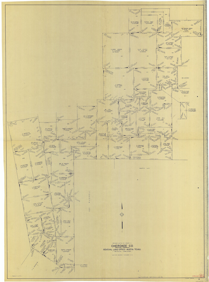
Cherokee County Working Sketch 10
Print $40.00
- Digital $50.00
Cherokee County Working Sketch 10
1957
Size 58.1 x 43.2 inches
Map/Doc 67965
Map of Matagorda Bay & Vicinity in Matagorda & Calhoun Counties Showing Subdivision for Mineral Development

Print $40.00
- Digital $50.00
Map of Matagorda Bay & Vicinity in Matagorda & Calhoun Counties Showing Subdivision for Mineral Development
1939
Size 46.1 x 55.5 inches
Map/Doc 2927
St. Louis Southwestern Railway of Texas

Print $20.00
- Digital $50.00
St. Louis Southwestern Railway of Texas
1906
Size 21.7 x 30.0 inches
Map/Doc 64452
Glasscock County Sketch File 16

Print $6.00
- Digital $50.00
Glasscock County Sketch File 16
1935
Size 14.4 x 10.9 inches
Map/Doc 24186
Culberson County Working Sketch Graphic Index, Sheet A (Sketches 1 to 40)

Print $40.00
- Digital $50.00
Culberson County Working Sketch Graphic Index, Sheet A (Sketches 1 to 40)
1943
Size 51.6 x 32.7 inches
Map/Doc 76514
Travis County Appraisal District Plat Map 2_0018

Print $20.00
- Digital $50.00
Travis County Appraisal District Plat Map 2_0018
Size 21.6 x 26.5 inches
Map/Doc 94208
Sterling County Sketch File 24

Print $6.00
- Digital $50.00
Sterling County Sketch File 24
1955
Size 11.1 x 8.5 inches
Map/Doc 37189
Uvalde County Sketch File 13

Print $20.00
- Digital $50.00
Uvalde County Sketch File 13
Size 14.3 x 29.1 inches
Map/Doc 12528