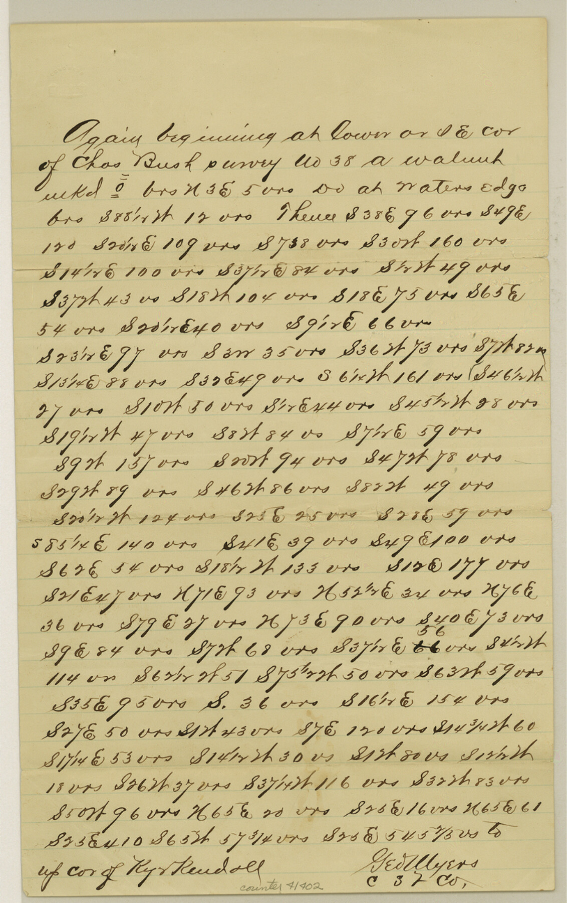
Zavala County Sketch File 37
[Connecting line from the southeast corner of the Chas. Bush survey no. 38 to the upper corner of the Kuykendall survey]
-
Map/Doc
41402
-
Collection
General Map Collection
-
People and Organizations
George Myers (Surveyor/Engineer)
-
Counties
Zavala
-
Subjects
Surveying Sketch File
-
Height x Width
12.9 x 8.1 inches
32.8 x 20.6 cm
-
Medium
paper, manuscript
Part of: General Map Collection
Presidio County Rolled Sketch 2

Print $20.00
- Digital $50.00
Presidio County Rolled Sketch 2
Size 30.2 x 18.6 inches
Map/Doc 7326
Pecos County Working Sketch 91a

Print $40.00
- Digital $50.00
Pecos County Working Sketch 91a
1965
Size 78.9 x 32.5 inches
Map/Doc 71563
Flight Mission No. CGN-3P, Frame 22, San Patricio County

Print $20.00
- Digital $50.00
Flight Mission No. CGN-3P, Frame 22, San Patricio County
1956
Size 18.6 x 22.3 inches
Map/Doc 86980
Matagorda County Working Sketch 31

Print $20.00
- Digital $50.00
Matagorda County Working Sketch 31
1982
Size 17.2 x 46.9 inches
Map/Doc 70889
Duval County Rolled Sketch 30

Print $20.00
- Digital $50.00
Duval County Rolled Sketch 30
1947
Size 15.8 x 27.8 inches
Map/Doc 5747
Atascosa County Sketch File 26

Print $4.00
- Digital $50.00
Atascosa County Sketch File 26
Size 8.2 x 12.7 inches
Map/Doc 13794
Donley County Sketch File B9

Print $20.00
- Digital $50.00
Donley County Sketch File B9
1920
Size 26.0 x 25.8 inches
Map/Doc 11379
Wichita County Rolled Sketch 9A

Print $20.00
- Digital $50.00
Wichita County Rolled Sketch 9A
1917
Size 32.4 x 27.9 inches
Map/Doc 8247
Reagan County Rolled Sketch 24

Print $26.00
- Digital $50.00
Reagan County Rolled Sketch 24
Size 44.0 x 39.9 inches
Map/Doc 9819
Right of Way and Track Map, Galveston, Harrisburg & San Antonio Ry. operated by the T. & N. O. R.R. Co., Victoria Division, Rosenberg to Beeville

Print $40.00
- Digital $50.00
Right of Way and Track Map, Galveston, Harrisburg & San Antonio Ry. operated by the T. & N. O. R.R. Co., Victoria Division, Rosenberg to Beeville
1918
Size 24.8 x 56.4 inches
Map/Doc 76164
Corpus Christi Harbor

Print $40.00
- Digital $50.00
Corpus Christi Harbor
1972
Size 36.9 x 52.3 inches
Map/Doc 73477
Red River County Working Sketch 50

Print $20.00
- Digital $50.00
Red River County Working Sketch 50
1970
Size 24.6 x 24.1 inches
Map/Doc 72033
You may also like
Tom Green County Working Sketch 13

Print $20.00
- Digital $50.00
Tom Green County Working Sketch 13
1981
Size 34.3 x 26.4 inches
Map/Doc 69382
Orange County Working Sketch 3

Print $20.00
- Digital $50.00
Orange County Working Sketch 3
1917
Size 12.7 x 20.3 inches
Map/Doc 71335
Flight Mission No. BRE-2P, Frame 131, Nueces County

Print $20.00
- Digital $50.00
Flight Mission No. BRE-2P, Frame 131, Nueces County
1956
Size 18.6 x 22.5 inches
Map/Doc 86804
Hall County Working Sketch 3

Print $20.00
- Digital $50.00
Hall County Working Sketch 3
1916
Size 15.6 x 17.1 inches
Map/Doc 63331
Brewster County Rolled Sketch 115

Digital $50.00
Brewster County Rolled Sketch 115
Size 11.5 x 138.4 inches
Map/Doc 8514
Jeff Davis County Rolled Sketch 25

Print $20.00
- Digital $50.00
Jeff Davis County Rolled Sketch 25
1953
Size 22.6 x 32.1 inches
Map/Doc 6373
Newton County Aerial Photograph Index Sheet 5

Print $20.00
- Digital $50.00
Newton County Aerial Photograph Index Sheet 5
1953
Size 24.1 x 17.7 inches
Map/Doc 83734
Flight Mission No. DIX-8P, Frame 86, Aransas County

Print $20.00
- Digital $50.00
Flight Mission No. DIX-8P, Frame 86, Aransas County
1956
Size 18.4 x 22.3 inches
Map/Doc 83911
Liberty County Sketch File 14

Print $4.00
- Digital $50.00
Liberty County Sketch File 14
1858
Size 12.9 x 8.1 inches
Map/Doc 29915
Menard County Sketch File 27

Print $8.00
- Digital $50.00
Menard County Sketch File 27
1943
Size 11.2 x 8.8 inches
Map/Doc 31564
Bosque County

Print $20.00
- Digital $50.00
Bosque County
1945
Size 42.6 x 33.0 inches
Map/Doc 77215
General Highway Map, Knox County, Texas

Print $20.00
General Highway Map, Knox County, Texas
1940
Size 18.3 x 24.8 inches
Map/Doc 79166