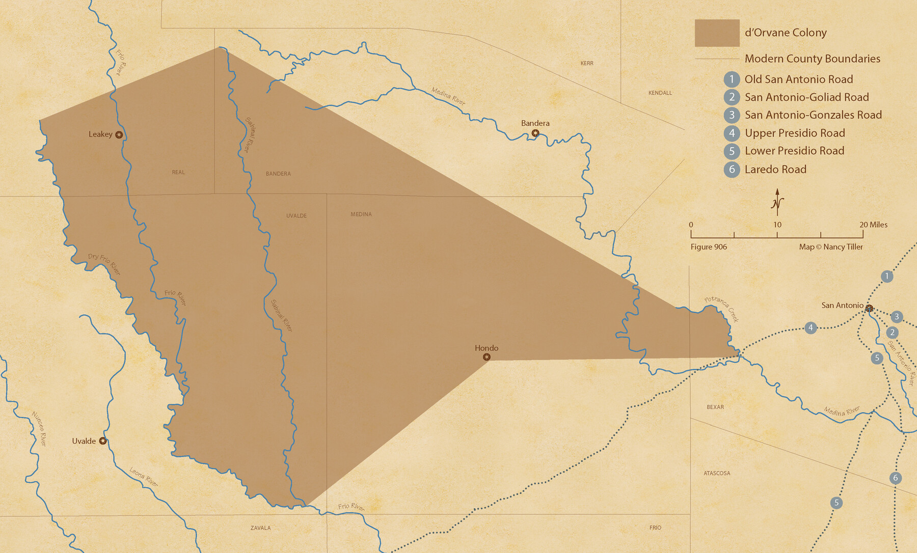
The d’Orvane Colony. June 3, 1842
Figure No. 906 from 'A Boundary Atlas of Texas, 1821-1845' by Jim Tiller
-
Map/Doc
96369
-
Collection
Nancy and Jim Tiller Digital Collection
-
Object Dates
2020/1/1 (Creation Date)
-
People and Organizations
Jim Tiller (Author)
Nancy Tiller (Cartographer)
Gang Gong (GIS Professional)
-
Subjects
Atlas Colony Republic of Texas Texas Boundaries
-
Height x Width
13.1 x 21.7 inches
33.3 x 55.1 cm
-
Medium
digital image
-
Comments
To purchase a digital PDF copy of "A Boundary Atlas of Texas, 1821-1845" see 96437.
Part of: Nancy and Jim Tiller Digital Collection
The Mexican Municipality of Colorado. Petition, December 30. 1835

Print $20.00
The Mexican Municipality of Colorado. Petition, December 30. 1835
2020
Size 15.4 x 21.6 inches
Map/Doc 96018
The Republic of Texas, Defined, December 19, 1836

Print $20.00
The Republic of Texas, Defined, December 19, 1836
2020
Size 24.6 x 21.7 inches
Map/Doc 96036
The Republic County of Houston. January 30, 1841

Print $20.00
The Republic County of Houston. January 30, 1841
2020
Size 19.7 x 21.8 inches
Map/Doc 96179
The Republic County of Goliad. December 29, 1845

Print $20.00
The Republic County of Goliad. December 29, 1845
2020
Size 17.5 x 21.7 inches
Map/Doc 96152
From Citizens of Colorado and Matagorda Counties for the Creation of a New County (Unnamed), August 6, 1840

Print $20.00
From Citizens of Colorado and Matagorda Counties for the Creation of a New County (Unnamed), August 6, 1840
2020
Size 18.5 x 21.7 inches
Map/Doc 96389
The Mexican Municipality of Austin. Proposed, No Date

Print $20.00
The Mexican Municipality of Austin. Proposed, No Date
2020
Size 17.0 x 21.7 inches
Map/Doc 96014
From Citizens of Nacogdoches County to Redefine the Boundaries of Nacogdoches County, December 2, 1841

Print $20.00
From Citizens of Nacogdoches County to Redefine the Boundaries of Nacogdoches County, December 2, 1841
2020
Size 22.5 x 21.7 inches
Map/Doc 96395
The Republic County of Washington. Spring 1842

Print $20.00
The Republic County of Washington. Spring 1842
2020
Size 11.8 x 21.7 inches
Map/Doc 96308
The Republic County of Colorado. December 29, 1845

Print $20.00
The Republic County of Colorado. December 29, 1845
2020
Size 18.4 x 21.7 inches
Map/Doc 96127
The Republic County of Victoria. December 29, 1845

Print $20.00
The Republic County of Victoria. December 29, 1845
2020
Size 24.3 x 21.7 inches
Map/Doc 96301
Wavell Empresario Colony. Proposed, March 9, 1826

Print $20.00
Wavell Empresario Colony. Proposed, March 9, 1826
2020
Size 16.0 x 21.7 inches
Map/Doc 96009
The Republic County of Harrison. January 16, 1843

Print $20.00
The Republic County of Harrison. January 16, 1843
2020
Size 18.6 x 21.7 inches
Map/Doc 96174
You may also like

Map of subdivision of submerged land in the Gulf of Mexico fronting on Matagorda Island and Peninsula

Print $40.00
- Digital $50.00
Map of subdivision of submerged land in the Gulf of Mexico fronting on Matagorda Island and Peninsula
1940
Size 28.3 x 60.5 inches
Map/Doc 2928
San Patricio County Sketch File 3

Print $10.00
- Digital $50.00
San Patricio County Sketch File 3
1850
Size 11.0 x 15.6 inches
Map/Doc 36029
San Augustine County Working Sketch 28

Print $20.00
- Digital $50.00
San Augustine County Working Sketch 28
2011
Size 23.4 x 36.7 inches
Map/Doc 90091
Rockwall County Sketch File 7

Print $4.00
Rockwall County Sketch File 7
1873
Size 12.6 x 8.3 inches
Map/Doc 35427
[Copy of a portion of] The Coast & Bays of Western Texas, St. Joseph's and Mustang Islands from Actual Survey, the Remainder from County Maps, Etc.
![72768, [Copy of a portion of] The Coast & Bays of Western Texas, St. Joseph's and Mustang Islands from Actual Survey, the Remainder from County Maps, Etc., General Map Collection](https://historictexasmaps.com/wmedia_w700/maps/72768.tif.jpg)
Print $20.00
- Digital $50.00
[Copy of a portion of] The Coast & Bays of Western Texas, St. Joseph's and Mustang Islands from Actual Survey, the Remainder from County Maps, Etc.
1857
Size 26.0 x 18.3 inches
Map/Doc 72768
Howard County Working Sketch 8

Print $20.00
- Digital $50.00
Howard County Working Sketch 8
1956
Size 25.3 x 31.3 inches
Map/Doc 66275
Rhyne Simpson Addition No. 2, City of Lubbock Section 3, Block O

Print $20.00
- Digital $50.00
Rhyne Simpson Addition No. 2, City of Lubbock Section 3, Block O
1957
Size 11.7 x 18.2 inches
Map/Doc 92752
Artesian Company Subdivision

Print $20.00
- Digital $50.00
Artesian Company Subdivision
1955
Size 12.0 x 15.8 inches
Map/Doc 92698
Map of Bandera County, Texas

Print $20.00
- Digital $50.00
Map of Bandera County, Texas
1879
Size 19.6 x 32.6 inches
Map/Doc 691
Flight Mission No. CGI-3N, Frame 67, Cameron County

Print $20.00
- Digital $50.00
Flight Mission No. CGI-3N, Frame 67, Cameron County
1954
Size 18.5 x 22.2 inches
Map/Doc 84561
Parker County Working Sketch 26

Print $20.00
- Digital $50.00
Parker County Working Sketch 26
2008
Map/Doc 88856