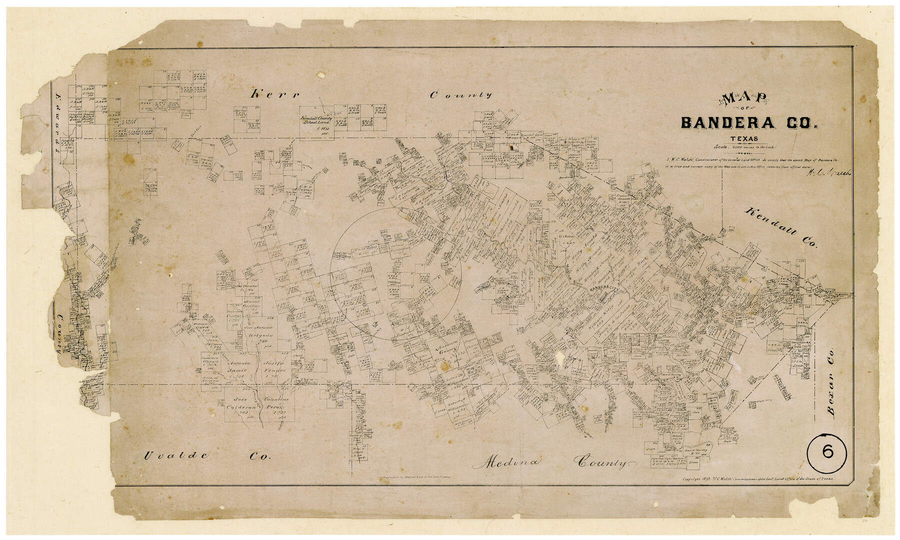
Map of Bandera County, Texas
-
Map/Doc
691
-
Collection
Maddox Collection
-
Object Dates
1879 (Creation Date)
-
People and Organizations
General Land Office (Publisher)
W.C. Walsh (GLO Commissioner)
August Gast & Co. (Lithographer)
-
Counties
Bandera
-
Subjects
County
-
Height x Width
19.6 x 32.6 inches
49.8 x 82.8 cm
-
Medium
paper, etching/engraving/lithograph
-
Scale
1:4000
-
Comments
Adopted with contributions from the 2010 State Employee Charitable Campaign (SECC).
-
Features
Commissioners Creek
Winans Creek
Comanche Trail
Cañon Creek
Little Creek
Seco Pass
Williams Creek
Hondo Creek
Thomas Creek
Medina River
Indian Creek
Don Pedro Spring
Galigher Spring
Verde Creek
East Prong [of Verde Creek]
Sabine Creek
Turkey Creek
Rio Frio
Sabinal Creek
Bandera Pass
Cypress Creek
Wallace Creek
Dry Arroyo
North Prong [of Bandera River]
South Prong [of Bandera River]
East Fork [of Bandera River]
Frio Trail
Myrtle Creek
Bear Creek
Pipe Creek
Privilego Creek
Mason's Creek
Bandera Creek
Bandera City
Part of: Maddox Collection
Map of Hays County, Texas

Print $20.00
- Digital $50.00
Map of Hays County, Texas
1880
Size 24.3 x 21.4 inches
Map/Doc 5029
Nolan County, Texas

Print $20.00
- Digital $50.00
Nolan County, Texas
1870
Size 23.9 x 19.5 inches
Map/Doc 744
Bell County, Texas

Print $20.00
- Digital $50.00
Bell County, Texas
1879
Size 23.7 x 29.0 inches
Map/Doc 516
Free & Williams Subdivision of the north half of Outlots 56 and 57

Print $20.00
- Digital $50.00
Free & Williams Subdivision of the north half of Outlots 56 and 57
Size 10.9 x 29.5 inches
Map/Doc 475
Map showing A. & N. W., Raymond Word #3, S.S. Hervey #496, and M. Farley #495 corrected to conform to the judgement in Cause #2888, Travis County District Court, State of Texas versus D. Sullivan, et al

Print $20.00
- Digital $50.00
Map showing A. & N. W., Raymond Word #3, S.S. Hervey #496, and M. Farley #495 corrected to conform to the judgement in Cause #2888, Travis County District Court, State of Texas versus D. Sullivan, et al
1915
Size 18.5 x 30.0 inches
Map/Doc 75812
Sketch of Surveys in Knox, Baylor, Haskell and Throckmorton Ctes

Print $40.00
- Digital $50.00
Sketch of Surveys in Knox, Baylor, Haskell and Throckmorton Ctes
1888
Size 43.3 x 58.5 inches
Map/Doc 4386
McCulloch County, Texas

Print $20.00
- Digital $50.00
McCulloch County, Texas
1879
Size 24.6 x 18.0 inches
Map/Doc 573
Working Sketch in Dimmit Co.

Print $20.00
- Digital $50.00
Working Sketch in Dimmit Co.
1883
Size 14.9 x 14.6 inches
Map/Doc 436
Wendlandt's Subdivision of part of Outlot 4, Division "Z"

Print $20.00
- Digital $50.00
Wendlandt's Subdivision of part of Outlot 4, Division "Z"
1910
Size 17.9 x 13.5 inches
Map/Doc 5041
[George Tenille Grant, Brazoria County, Texas]
![10751, [George Tenille Grant, Brazoria County, Texas], Maddox Collection](https://historictexasmaps.com/wmedia_w700/maps/10751.tif.jpg)
Print $2.00
- Digital $50.00
[George Tenille Grant, Brazoria County, Texas]
Size 11.2 x 9.2 inches
Map/Doc 10751
Floyd County, Texas

Print $20.00
- Digital $50.00
Floyd County, Texas
1889
Size 24.8 x 19.2 inches
Map/Doc 626
Hall County, Texas

Print $20.00
- Digital $50.00
Hall County, Texas
1880
Size 24.9 x 20.4 inches
Map/Doc 480
You may also like
Kinney County Working Sketch 52

Print $20.00
- Digital $50.00
Kinney County Working Sketch 52
1980
Size 26.1 x 31.0 inches
Map/Doc 70234
Revised Map of Austin, Texas

Print $20.00
Revised Map of Austin, Texas
1885
Size 16.5 x 14.0 inches
Map/Doc 76272
Kimble County Rolled Sketch 40

Print $20.00
- Digital $50.00
Kimble County Rolled Sketch 40
Size 27.5 x 22.4 inches
Map/Doc 6530
S. M. S. Flat Top Ranch

Print $6.00
- Digital $50.00
S. M. S. Flat Top Ranch
1955
Size 23.2 x 32.8 inches
Map/Doc 2102
Bird's Eye View of the City of Belton, Bell County, Texas

Print $20.00
Bird's Eye View of the City of Belton, Bell County, Texas
1881
Size 18.5 x 23.8 inches
Map/Doc 89074
Menard County Sketch File 21

Print $40.00
- Digital $50.00
Menard County Sketch File 21
1913
Size 14.1 x 14.8 inches
Map/Doc 31551

Gillespie County, Texas

Print $20.00
- Digital $50.00
Gillespie County, Texas
1879
Size 21.2 x 26.9 inches
Map/Doc 547
Nueces County NRC Article 33.136 Sketch 22

Print $42.00
Nueces County NRC Article 33.136 Sketch 22
2023
Map/Doc 97180
Matagorda County Working Sketch 24

Print $20.00
- Digital $50.00
Matagorda County Working Sketch 24
1972
Size 25.3 x 34.5 inches
Map/Doc 70882
Menard County Working Sketch 20

Print $20.00
- Digital $50.00
Menard County Working Sketch 20
1947
Size 38.5 x 34.9 inches
Map/Doc 70967
Callahan County Sketch File 2

Print $8.00
- Digital $50.00
Callahan County Sketch File 2
1858
Size 11.8 x 8.7 inches
Map/Doc 35853