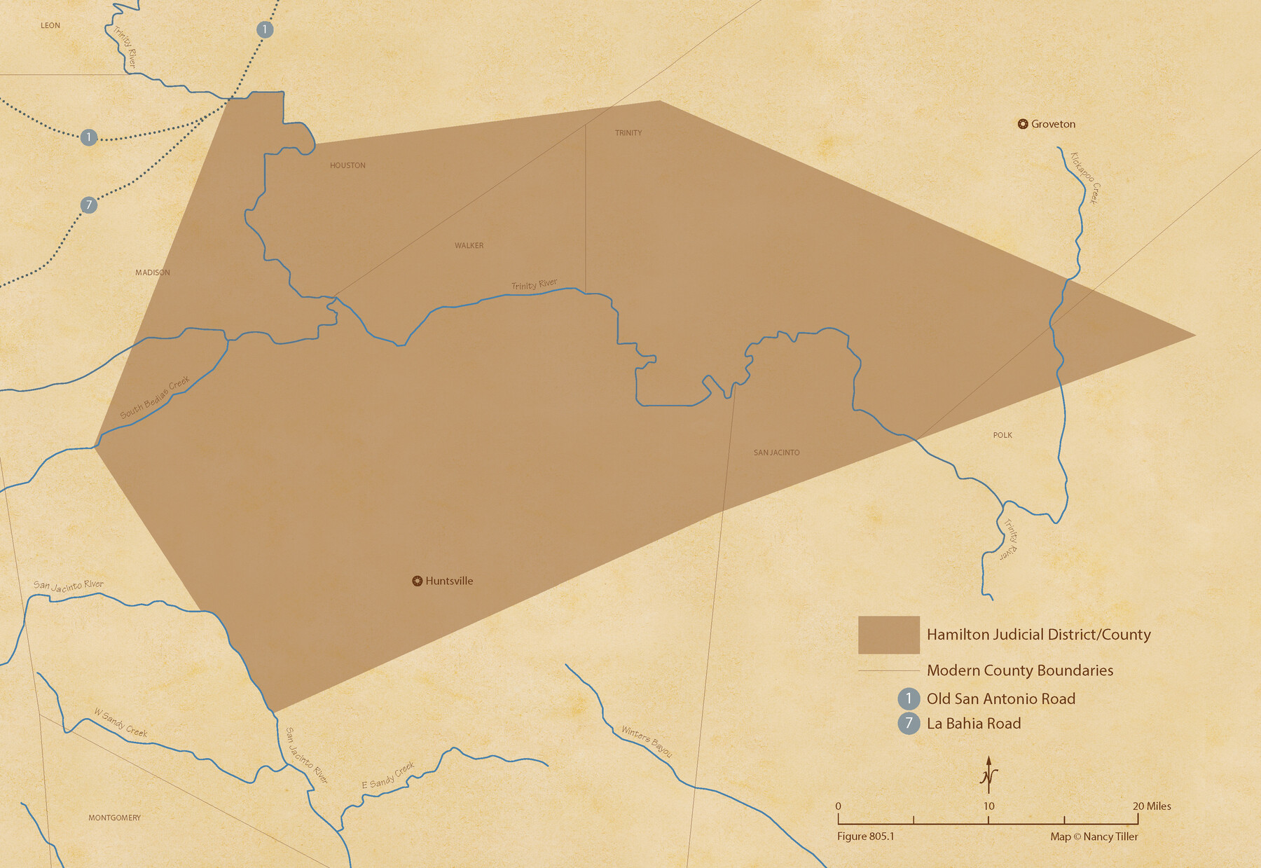
The Judicial District/County of Hamilton. Created, February 2, 1842
Figure No. 805.1 from 'A Boundary Atlas of Texas, 1821-1845' by Jim Tiller
-
Map/Doc
96329
-
Collection
Nancy and Jim Tiller Digital Collection
-
Object Dates
2020/1/1 (Creation Date)
-
People and Organizations
Jim Tiller (Author)
Nancy Tiller (Cartographer)
Gang Gong (GIS Professional)
-
Subjects
Atlas Republic of Texas Texas Boundaries
-
Height x Width
14.9 x 21.7 inches
37.9 x 55.1 cm
-
Medium
digital image
-
Comments
To purchase a digital PDF copy of "A Boundary Atlas of Texas, 1821-1845" see 96437.
Part of: Nancy and Jim Tiller Digital Collection
The Republic County of Fayette. Created, December 14, 1837

Print $20.00
The Republic County of Fayette. Created, December 14, 1837
2020
Size 14.7 x 21.7 inches
Map/Doc 96131
The Republic County of Colorado. Proposed, Late Fall 1837

Print $20.00
The Republic County of Colorado. Proposed, Late Fall 1837
2020
Size 18.4 x 21.7 inches
Map/Doc 96118
The Judicial District/County of Hamilton. Created, February 2, 1842

Print $20.00
The Judicial District/County of Hamilton. Created, February 2, 1842
2020
Size 14.9 x 21.7 inches
Map/Doc 96329
The Chief Justice County of Liberty. Lands in Conflict with Harrisburg County

Print $20.00
The Chief Justice County of Liberty. Lands in Conflict with Harrisburg County
2020
Size 20.5 x 21.7 inches
Map/Doc 96056
The Republic County of Houston. Spring 1842

Print $20.00
The Republic County of Houston. Spring 1842
2020
Size 19.7 x 21.8 inches
Map/Doc 96182
From Citizens of Nacogdoches County to Redefine the Boundaries of Nacogdoches County, December 2, 1841

Print $20.00
From Citizens of Nacogdoches County to Redefine the Boundaries of Nacogdoches County, December 2, 1841
2020
Size 22.5 x 21.7 inches
Map/Doc 96395
The Republic County of Harrison. Spring 1842

Print $20.00
The Republic County of Harrison. Spring 1842
2020
Size 18.6 x 21.7 inches
Map/Doc 96173
Power and Hewetson Empresario Colony. June 11, 1828

Print $20.00
Power and Hewetson Empresario Colony. June 11, 1828
2020
Size 17.5 x 21.7 inches
Map/Doc 96003
The Republic County of Travis. December 29, 1845

Print $20.00
The Republic County of Travis. December 29, 1845
2020
Size 20.8 x 21.6 inches
Map/Doc 96293
The Republic County of Bowie. Spring 1842

Print $20.00
The Republic County of Bowie. Spring 1842
2020
Size 19.5 x 21.7 inches
Map/Doc 96105
Republic Counties. December 29, 1845

Print $20.00
Republic Counties. December 29, 1845
2020
Size 24.5 x 21.7 inches
Map/Doc 96319
From Citizens of Red River County for the Creation of a New County to be Called Aurora, December 3, 1840

Print $20.00
From Citizens of Red River County for the Creation of a New County to be Called Aurora, December 3, 1840
2020
Size 19.8 x 21.7 inches
Map/Doc 96391
You may also like
Hays County Boundary File 42

Print $6.00
- Digital $50.00
Hays County Boundary File 42
Size 9.1 x 3.7 inches
Map/Doc 54609
Navigation Maps of Gulf Intracoastal Waterway, Port Arthur to Brownsville, Texas

Print $4.00
- Digital $50.00
Navigation Maps of Gulf Intracoastal Waterway, Port Arthur to Brownsville, Texas
1951
Size 16.7 x 21.6 inches
Map/Doc 65420
Rhyne Simpson Addition No. 2, City of Lubbock Section 3, Block O

Print $20.00
- Digital $50.00
Rhyne Simpson Addition No. 2, City of Lubbock Section 3, Block O
1957
Size 11.7 x 18.2 inches
Map/Doc 92752
Outer Continental Shelf Leasing Maps (Louisiana Offshore Operations)

Print $20.00
- Digital $50.00
Outer Continental Shelf Leasing Maps (Louisiana Offshore Operations)
1959
Size 17.9 x 14.0 inches
Map/Doc 76097
Grayson County Sketch File 21

Print $14.00
- Digital $50.00
Grayson County Sketch File 21
Size 7.7 x 17.8 inches
Map/Doc 24495
Nautical Chart 885-SC Intracoastal Waterway - Ellender to Galveston Bay, Louisiana-Texas

Print $20.00
- Digital $50.00
Nautical Chart 885-SC Intracoastal Waterway - Ellender to Galveston Bay, Louisiana-Texas
1972
Size 15.9 x 26.8 inches
Map/Doc 75910
Rusk County Working Sketch 21

Print $20.00
- Digital $50.00
Rusk County Working Sketch 21
1953
Size 27.6 x 28.3 inches
Map/Doc 63657
[Right of Way and Track Map, the Missouri, Kansas and Texas Ry. of Texas - Henrietta Division]
![64757, [Right of Way and Track Map, the Missouri, Kansas and Texas Ry. of Texas - Henrietta Division], General Map Collection](https://historictexasmaps.com/wmedia_w700/maps/64757.tif.jpg)
Print $20.00
- Digital $50.00
[Right of Way and Track Map, the Missouri, Kansas and Texas Ry. of Texas - Henrietta Division]
1918
Size 11.8 x 26.9 inches
Map/Doc 64757
Jasper County Sketch File 12

Print $4.00
- Digital $50.00
Jasper County Sketch File 12
Size 8.8 x 10.0 inches
Map/Doc 27792
Revised Map of the State of Texas

Print $20.00
Revised Map of the State of Texas
1876
Size 20.2 x 19.6 inches
Map/Doc 79301
[Tom Green County]
![16901, [Tom Green County], General Map Collection](https://historictexasmaps.com/wmedia_w700/maps/16901.tif.jpg)
Print $20.00
- Digital $50.00
[Tom Green County]
1888
Size 33.2 x 34.4 inches
Map/Doc 16901
Milam County Working Sketch 17

Print $40.00
- Digital $50.00
Milam County Working Sketch 17
1972
Size 54.7 x 32.2 inches
Map/Doc 89031