
Reeves County Working Sketch 45
-
Map/Doc
63488
-
Collection
General Map Collection
-
Object Dates
5/6/1974 (Creation Date)
-
Counties
Reeves
-
Subjects
Surveying Working Sketch
-
Height x Width
46.9 x 32.3 inches
119.1 x 82.0 cm
-
Scale
1" = 500 varas
Part of: General Map Collection

Floyd County Sketch File 27

Print $6.00
- Digital $50.00
Floyd County Sketch File 27
1900
Size 14.4 x 8.9 inches
Map/Doc 22789
United States - Gulf Coast - From Latitude 26° 33' to the Rio Grande Texas

Print $20.00
- Digital $50.00
United States - Gulf Coast - From Latitude 26° 33' to the Rio Grande Texas
1919
Size 27.5 x 18.3 inches
Map/Doc 72855
Right of Way and Track Map International & Gt Northern Ry. operated by the International & Gt. Northern Ry. Co., San Antonio Division

Print $40.00
- Digital $50.00
Right of Way and Track Map International & Gt Northern Ry. operated by the International & Gt. Northern Ry. Co., San Antonio Division
1917
Size 25.4 x 58.1 inches
Map/Doc 64787
Grayson County Working Sketch 5

Print $20.00
- Digital $50.00
Grayson County Working Sketch 5
1939
Size 28.4 x 40.6 inches
Map/Doc 63244
Starr County Sketch File 26

Print $20.00
- Digital $50.00
Starr County Sketch File 26
1923
Size 31.7 x 27.2 inches
Map/Doc 10607
Bastrop County Working Sketch 13

Print $20.00
- Digital $50.00
Bastrop County Working Sketch 13
1979
Size 23.6 x 30.0 inches
Map/Doc 67313
Brazos County Sketch File 1

Print $4.00
- Digital $50.00
Brazos County Sketch File 1
1858
Size 10.4 x 7.6 inches
Map/Doc 15550
Grayson County Working Sketch 2

Print $20.00
- Digital $50.00
Grayson County Working Sketch 2
1939
Size 27.8 x 40.9 inches
Map/Doc 63241
Briscoe County Sketch File 10

Print $4.00
- Digital $50.00
Briscoe County Sketch File 10
1901
Size 11.2 x 8.7 inches
Map/Doc 16420
Vicinity of San Luis Pass, Galveston Island, Texas
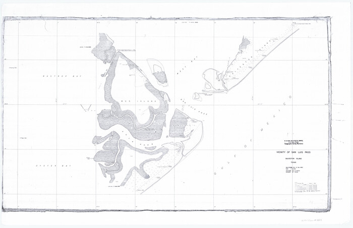
Print $40.00
- Digital $50.00
Vicinity of San Luis Pass, Galveston Island, Texas
1933
Size 36.9 x 57.2 inches
Map/Doc 69942
El Paso County Boundary File 19

Print $9.00
- Digital $50.00
El Paso County Boundary File 19
Size 13.6 x 8.7 inches
Map/Doc 53206
You may also like
Karnes County Rolled Sketch 3A

Print $20.00
- Digital $50.00
Karnes County Rolled Sketch 3A
1959
Size 23.9 x 28.6 inches
Map/Doc 6455
Montague County Rolled Sketch 2

Print $20.00
- Digital $50.00
Montague County Rolled Sketch 2
1940
Size 32.5 x 35.5 inches
Map/Doc 9525
Flight Mission No. BRE-2P, Frame 8, Nueces County

Print $20.00
- Digital $50.00
Flight Mission No. BRE-2P, Frame 8, Nueces County
1956
Size 18.7 x 22.6 inches
Map/Doc 86717
Coleman County Sketch File 45

Print $20.00
- Digital $50.00
Coleman County Sketch File 45
1897
Size 23.9 x 23.8 inches
Map/Doc 11124
Bastrop County Working Sketch 8

Print $20.00
- Digital $50.00
Bastrop County Working Sketch 8
1937
Size 23.9 x 43.1 inches
Map/Doc 67308
Crockett County Working Sketch Graphic Index - northeast part

Print $20.00
- Digital $50.00
Crockett County Working Sketch Graphic Index - northeast part
1976
Size 35.6 x 46.4 inches
Map/Doc 76511
A Geographically Correct Map of the State of Texas

Print $20.00
- Digital $50.00
A Geographically Correct Map of the State of Texas
1876
Size 20.4 x 21.7 inches
Map/Doc 95361
Location from Del Rio to Johnstone, Southern Pacific Railway Co.

Print $20.00
- Digital $50.00
Location from Del Rio to Johnstone, Southern Pacific Railway Co.
Size 13.3 x 44.3 inches
Map/Doc 64290
Crockett County Rolled Sketch 27A
Print $40.00
- Digital $50.00
Crockett County Rolled Sketch 27A
1925
Size 22.3 x 59.5 inches
Map/Doc 8692
Map of the Rio Grande & Eagle Pass Ry. from Sections 14-20 Inclusive, Webb County

Print $40.00
- Digital $50.00
Map of the Rio Grande & Eagle Pass Ry. from Sections 14-20 Inclusive, Webb County
1909
Size 25.3 x 55.6 inches
Map/Doc 64657
Red River County Working Sketch 47

Print $6.00
- Digital $50.00
Red River County Working Sketch 47
1969
Size 34.3 x 24.2 inches
Map/Doc 72030
Sketch of Kent Co.

Print $20.00
- Digital $50.00
Sketch of Kent Co.
1884
Size 15.1 x 16.5 inches
Map/Doc 439