El Paso County Rolled Sketch 61
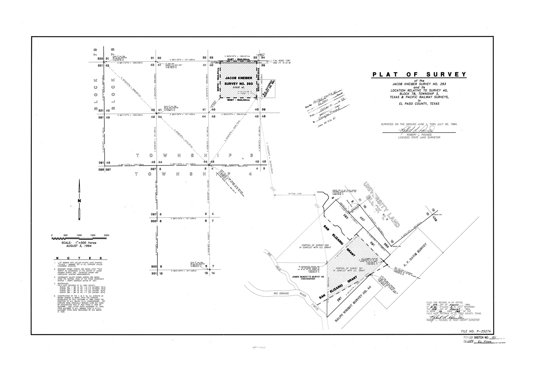
Plat of survey of the Jacob Kneiber survey no. 293 and its location relative to survey 40, Block 78, Township 3, Texas & Pacific Railway surveys in El Paso County, Texas
-
Map/Doc
5853
-
Collection
General Map Collection
-
Object Dates
1994/7/30 (Survey Date)
1994/10/21 (File Date)
1994/8/3 (Creation Date)
-
People and Organizations
Robert L. Pounds (Surveyor/Engineer)
-
Counties
El Paso
-
Subjects
Surveying Rolled Sketch
-
Height x Width
27.8 x 39.0 inches
70.6 x 99.1 cm
-
Medium
mylar, print
-
Scale
1" = 500 varas
-
Comments
See El Paso County Sketch File 41 (22238) for report and El Paso County Sketch File 31 (22084) for additional plats and correspondence.
Related maps
El Paso County Sketch File 31

Print $185.00
- Digital $50.00
El Paso County Sketch File 31
1968
Size 8.9 x 17.7 inches
Map/Doc 22084
El Paso County Sketch File 41

Print $6.00
- Digital $50.00
El Paso County Sketch File 41
1994
Size 11.4 x 8.8 inches
Map/Doc 22238
Part of: General Map Collection
Presidio County Working Sketch 137

Print $20.00
- Digital $50.00
Presidio County Working Sketch 137
1990
Size 24.1 x 42.8 inches
Map/Doc 71815
Hays County Rolled Sketch 32

Print $20.00
- Digital $50.00
Hays County Rolled Sketch 32
2003
Size 15.6 x 20.0 inches
Map/Doc 78489
Parker County Sketch File 20

Print $4.00
- Digital $50.00
Parker County Sketch File 20
Size 5.2 x 6.5 inches
Map/Doc 33558
Hemphill County Working Sketch 16

Print $20.00
- Digital $50.00
Hemphill County Working Sketch 16
1971
Size 27.0 x 40.0 inches
Map/Doc 66111
Cameron County Rolled Sketch 30

Print $20.00
- Digital $50.00
Cameron County Rolled Sketch 30
1930
Size 36.3 x 24.4 inches
Map/Doc 5394
Crockett County Working Sketch 2

Print $20.00
- Digital $50.00
Crockett County Working Sketch 2
Size 18.4 x 14.9 inches
Map/Doc 68335
Industrial - Commercial - Progressive Dallas

Industrial - Commercial - Progressive Dallas
1940
Size 19.1 x 23.7 inches
Map/Doc 96509
Liberty County Rolled Sketch F

Print $20.00
- Digital $50.00
Liberty County Rolled Sketch F
Size 24.9 x 25.5 inches
Map/Doc 6621
Map of Eastland Co.

Print $20.00
- Digital $50.00
Map of Eastland Co.
1896
Size 40.0 x 42.8 inches
Map/Doc 78411
Shelby County Working Sketch 9

Print $20.00
- Digital $50.00
Shelby County Working Sketch 9
1945
Size 30.8 x 28.5 inches
Map/Doc 63862
Little River, Faubion Bridge Sheet

Print $20.00
- Digital $50.00
Little River, Faubion Bridge Sheet
1914
Size 18.5 x 27.6 inches
Map/Doc 69682
Right-of-Way Map Seawall Extension Galveston Island

Print $40.00
- Digital $50.00
Right-of-Way Map Seawall Extension Galveston Island
1958
Size 16.4 x 62.8 inches
Map/Doc 73617
You may also like
The Peters Colony. November 9, 1841

Print $20.00
The Peters Colony. November 9, 1841
2020
Size 21.7 x 21.7 inches
Map/Doc 96363
State of Texas

Print $40.00
- Digital $50.00
State of Texas
1948
Size 44.6 x 56.8 inches
Map/Doc 78634
Travis County Sketch File 57

Print $8.00
- Digital $50.00
Travis County Sketch File 57
1947
Size 11.4 x 8.8 inches
Map/Doc 38402
[H. & G. N. Block 1, G. C. & S. F. Block Z]
![91168, [H. & G. N. Block 1, G. C. & S. F. Block Z], Twichell Survey Records](https://historictexasmaps.com/wmedia_w700/maps/91168-1.tif.jpg)
Print $3.00
- Digital $50.00
[H. & G. N. Block 1, G. C. & S. F. Block Z]
Size 16.8 x 10.5 inches
Map/Doc 91168
Map of Rockport Texas, Aransas County

Print $20.00
- Digital $50.00
Map of Rockport Texas, Aransas County
1888
Size 29.0 x 20.5 inches
Map/Doc 380
Victoria County Rolled Sketch 4A

Print $40.00
- Digital $50.00
Victoria County Rolled Sketch 4A
Size 66.4 x 43.9 inches
Map/Doc 10095
Harrison County Working Sketch 12

Print $20.00
- Digital $50.00
Harrison County Working Sketch 12
1960
Size 26.6 x 31.4 inches
Map/Doc 66032
Plan of the Battle of Buena-Vista fought February 22nd and 23rd, 1847

Print $20.00
- Digital $50.00
Plan of the Battle of Buena-Vista fought February 22nd and 23rd, 1847
1847
Size 17.6 x 21.6 inches
Map/Doc 95829
[Sketch of area just south of Levi Pruitt survey]
![91855, [Sketch of area just south of Levi Pruitt survey], Twichell Survey Records](https://historictexasmaps.com/wmedia_w700/maps/91855-1.tif.jpg)
Print $20.00
- Digital $50.00
[Sketch of area just south of Levi Pruitt survey]
1924
Size 17.0 x 17.8 inches
Map/Doc 91855
Map of the Public Land States and Territories constructed from the Public Surveys and other official sources in the General Land Office

Print $20.00
- Digital $50.00
Map of the Public Land States and Territories constructed from the Public Surveys and other official sources in the General Land Office
Size 31.0 x 46.6 inches
Map/Doc 94152
Map of La Salle County

Print $20.00
- Digital $50.00
Map of La Salle County
1877
Size 29.8 x 21.1 inches
Map/Doc 3797
Bowie County Working Sketch 28

Print $20.00
- Digital $50.00
Bowie County Working Sketch 28
1988
Size 35.1 x 41.5 inches
Map/Doc 67432