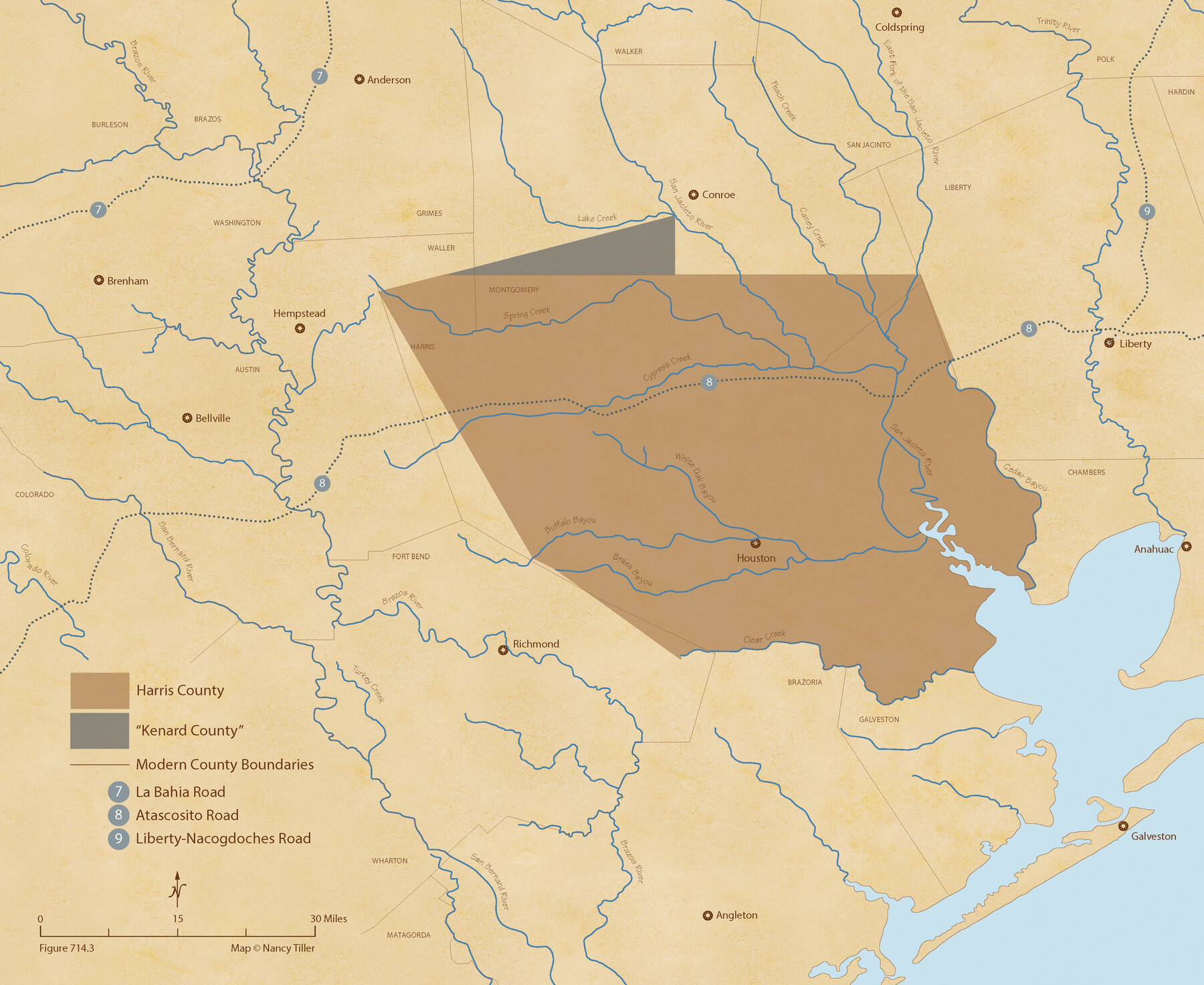
The Republic County of Harris. May 15, 1838
Figure No. 714.3 from 'A Boundary Atlas of Texas, 1821-1845' by Jim Tiller
-
Map/Doc
96163
-
Collection
Nancy and Jim Tiller Digital Collection
-
Object Dates
2020/1/1 (Creation Date)
-
People and Organizations
Jim Tiller (Author)
Nancy Tiller (Cartographer)
Gang Gong (GIS Professional)
-
Counties
Harris
-
Subjects
Atlas County Republic of Texas Texas Boundaries
-
Height x Width
17.7 x 21.7 inches
45.0 x 55.1 cm
-
Medium
digital image
-
Comments
To purchase a digital PDF copy of "A Boundary Atlas of Texas, 1821-1845" see 96437.
Part of: Nancy and Jim Tiller Digital Collection
The Republic County of Rusk. December 31, 1844

Print $20.00
The Republic County of Rusk. December 31, 1844
2020
Size 19.1 x 21.7 inches
Map/Doc 96266
The Republic County of Harrison. Created, January 28, 1839

Print $20.00
The Republic County of Harrison. Created, January 28, 1839
2020
Size 18.6 x 21.7 inches
Map/Doc 96169
Republic Counties. January 1, 1843

Print $20.00
Republic Counties. January 1, 1843
2020
Size 24.5 x 21.7 inches
Map/Doc 96316
The Mexican Municipality of Brazoria. December 28, 1834

Print $20.00
The Mexican Municipality of Brazoria. December 28, 1834
2020
Size 16.5 x 21.7 inches
Map/Doc 96017
The Judicial District/County of Burnet. Boundaries Redefined, December 6, 1841

Print $20.00
The Judicial District/County of Burnet. Boundaries Redefined, December 6, 1841
2020
Size 19.2 x 21.6 inches
Map/Doc 96323
Republic Counties. January 1, 1840

Print $20.00
Republic Counties. January 1, 1840
2020
Size 24.5 x 21.7 inches
Map/Doc 96313
The Republic County of Galveston. January 20, 1841

Print $20.00
The Republic County of Galveston. January 20, 1841
2020
Size 14.7 x 21.9 inches
Map/Doc 96145
From Citizens of Nacogdoches County for the Creation of a New County to be Called Smith, September 4, 1841

Print $20.00
From Citizens of Nacogdoches County for the Creation of a New County to be Called Smith, September 4, 1841
2020
Size 18.3 x 21.7 inches
Map/Doc 96392
The Republic County of Nacogdoches. February 1, 1842

Print $20.00
The Republic County of Nacogdoches. February 1, 1842
2020
Size 15.9 x 21.8 inches
Map/Doc 96247
Vehlein and Company Empresario Colony. November 17, 1828

Print $20.00
Vehlein and Company Empresario Colony. November 17, 1828
2020
Size 20.8 x 21.7 inches
Map/Doc 96008
The Judicial District/County of Pashcal. Abolished, Spring 1842

Print $20.00
The Judicial District/County of Pashcal. Abolished, Spring 1842
2020
Size 15.0 x 21.7 inches
Map/Doc 96345
The Republic County of Colorado. December 29, 1845

Print $20.00
The Republic County of Colorado. December 29, 1845
2020
Size 18.4 x 21.7 inches
Map/Doc 96127
You may also like
Trinity County Sketch File 24

Print $4.00
- Digital $50.00
Trinity County Sketch File 24
Size 7.5 x 10.5 inches
Map/Doc 38556
Flight Mission No. DQO-11K, Frame 16, Galveston County

Print $20.00
- Digital $50.00
Flight Mission No. DQO-11K, Frame 16, Galveston County
1952
Size 18.8 x 22.5 inches
Map/Doc 85209
Armstrong County Sketch File 3

Print $40.00
- Digital $50.00
Armstrong County Sketch File 3
1883
Size 27.4 x 29.4 inches
Map/Doc 10839
Starr County Working Sketch 6

Print $20.00
- Digital $50.00
Starr County Working Sketch 6
Size 24.3 x 16.2 inches
Map/Doc 63922

Val Verde County Sketch File A1

Print $6.00
- Digital $50.00
Val Verde County Sketch File A1
1895
Size 14.4 x 9.2 inches
Map/Doc 39038
Right of Way and Track Map, Galveston, Harrisburg & San Antonio Ry. operated by the T. & N. O. R.R. Co., Victoria Division, Rosenberg to Beeville

Print $40.00
- Digital $50.00
Right of Way and Track Map, Galveston, Harrisburg & San Antonio Ry. operated by the T. & N. O. R.R. Co., Victoria Division, Rosenberg to Beeville
Size 24.3 x 55.8 inches
Map/Doc 76162
Mills County Working Sketch 20

Print $20.00
- Digital $50.00
Mills County Working Sketch 20
1970
Size 43.1 x 43.4 inches
Map/Doc 71050
West Part of Jeff Davis Co.

Print $20.00
- Digital $50.00
West Part of Jeff Davis Co.
1977
Size 35.0 x 45.2 inches
Map/Doc 73195
Harris County Working Sketch 72

Print $20.00
- Digital $50.00
Harris County Working Sketch 72
1958
Size 24.9 x 43.6 inches
Map/Doc 65964
Concho County Sketch File 46

Print $24.00
- Digital $50.00
Concho County Sketch File 46
1961
Size 14.2 x 8.6 inches
Map/Doc 19213
Hale County Rolled Sketch 5

Print $20.00
- Digital $50.00
Hale County Rolled Sketch 5
1893
Size 29.0 x 22.2 inches
Map/Doc 9094