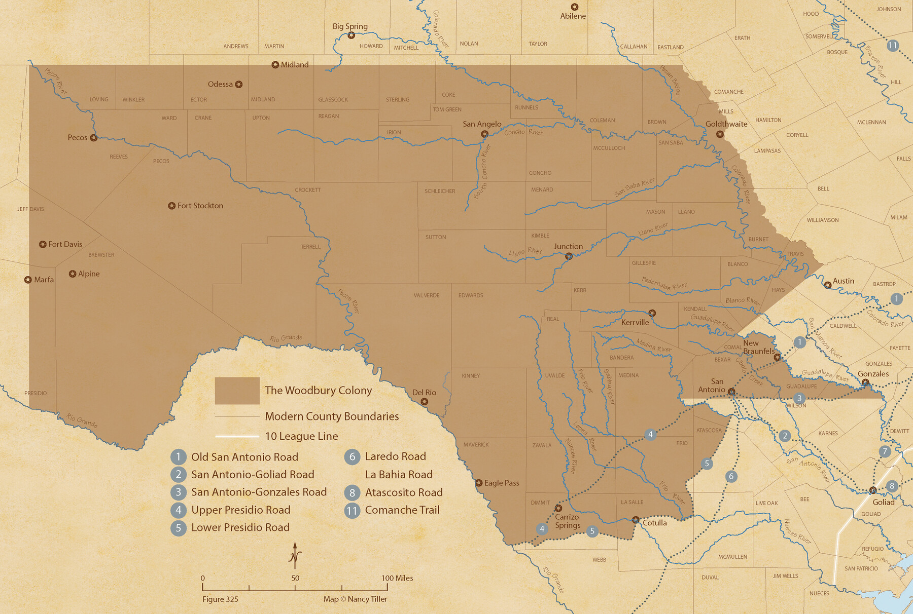
Woodbury Empresario Colony. November 14, 1826
Figure No. 325 from 'A Boundary Atlas of Texas, 1821-1845' by Jim Tiller
-
Map/Doc
96011
-
Collection
Nancy and Jim Tiller Digital Collection
-
Object Dates
2020/1/1 (Creation Date)
-
People and Organizations
Jim Tiller (Author)
Nancy Tiller (Cartographer)
Gang Gong (GIS Professional)
-
Subjects
Atlas Colony Mexican Texas Texas Boundaries
-
Height x Width
14.7 x 21.8 inches
37.3 x 55.4 cm
-
Medium
digital image
-
Comments
To purchase a digital PDF copy of "A Boundary Atlas of Texas, 1821-1845" see 96437.
Part of: Nancy and Jim Tiller Digital Collection
The Chief Justice County of Jasper. Lands in Conflict with Sabine County

Print $20.00
The Chief Justice County of Jasper. Lands in Conflict with Sabine County
2020
Size 18.3 x 21.7 inches
Map/Doc 96053
Republic Counties. January 1, 1845

Print $20.00
Republic Counties. January 1, 1845
2020
Size 24.5 x 21.7 inches
Map/Doc 96318
The Republic County of Jackson. January 19, 1841

Print $20.00
The Republic County of Jackson. January 19, 1841
2020
Size 15.6 x 21.8 inches
Map/Doc 96188
The Republic County of Robertson. December 29, 1845

Print $20.00
The Republic County of Robertson. December 29, 1845
2020
Size 16.9 x 21.7 inches
Map/Doc 96264
The Republic County of Jackson. December 29, 1845

Print $20.00
The Republic County of Jackson. December 29, 1845
2020
Size 15.6 x 21.8 inches
Map/Doc 96192
The Chief Justice County of Sabine. Lands in Conflict with Jasper and San Augustine Counties

Print $20.00
The Chief Justice County of Sabine. Lands in Conflict with Jasper and San Augustine Counties
2020
Size 20.0 x 21.7 inches
Map/Doc 96069
Text and Map Related to the Creation of a New County Out of Red River and Shelby Counties (Unnamed), Undated

Print $20.00
Text and Map Related to the Creation of a New County Out of Red River and Shelby Counties (Unnamed), Undated
2020
Size 12.5 x 19.7 inches
Map/Doc 96403
The Mexican Company Empresario Colony. May 1, 1832

Print $20.00
The Mexican Company Empresario Colony. May 1, 1832
2020
Size 15.0 x 21.7 inches
Map/Doc 95999
The Republic County of Shelby. Spring 1842

Print $20.00
The Republic County of Shelby. Spring 1842
2020
Size 20.0 x 21.7 inches
Map/Doc 96284
The Republic County of Jackson. September 17, 1838

Print $20.00
The Republic County of Jackson. September 17, 1838
2020
Size 15.6 x 21.8 inches
Map/Doc 96185
The Republic County of Harris. Proposed, Late Fall 1837

Print $20.00
The Republic County of Harris. Proposed, Late Fall 1837
2020
Size 17.7 x 21.7 inches
Map/Doc 96161
From Citizens of Washington County Living East of the Brazos River and West of the Navasota River for the Creation of a New County (Unnamed), Undated

Print $20.00
From Citizens of Washington County Living East of the Brazos River and West of the Navasota River for the Creation of a New County (Unnamed), Undated
2020
Size 20.4 x 21.7 inches
Map/Doc 96408
You may also like
Flight Mission No. DQN-5K, Frame 26, Calhoun County

Print $20.00
- Digital $50.00
Flight Mission No. DQN-5K, Frame 26, Calhoun County
1953
Size 18.6 x 22.3 inches
Map/Doc 84377
Goliad Co. Sketch

Print $3.00
- Digital $50.00
Goliad Co. Sketch
1900
Size 15.6 x 11.3 inches
Map/Doc 417
Hardin County Working Sketch 11

Print $20.00
- Digital $50.00
Hardin County Working Sketch 11
1929
Size 25.4 x 24.1 inches
Map/Doc 63409
Texas Land Commissioner George P. Bush's Energy Map of Texas Showing Significant Events and Well & Pipeline Locations Between 1543 and 2015

Print $20.00
- Digital $50.00
Texas Land Commissioner George P. Bush's Energy Map of Texas Showing Significant Events and Well & Pipeline Locations Between 1543 and 2015
2015
Size 33.3 x 36.3 inches
Map/Doc 93978
[H. & T. C. RR. Company, Block 47, Map C]
![91258, [H. & T. C. RR. Company, Block 47, Map C], Twichell Survey Records](https://historictexasmaps.com/wmedia_w700/maps/91258-1.tif.jpg)
Print $20.00
- Digital $50.00
[H. & T. C. RR. Company, Block 47, Map C]
Size 34.1 x 20.7 inches
Map/Doc 91258
The Judicial District/County of Menard. December 7, 1841

Print $20.00
The Judicial District/County of Menard. December 7, 1841
2020
Size 22.4 x 21.7 inches
Map/Doc 96336
Trinity River, White Rock Creek Sheet

Print $6.00
- Digital $50.00
Trinity River, White Rock Creek Sheet
1923
Size 33.0 x 24.2 inches
Map/Doc 65198
Flight Mission No. DQO-2K, Frame 140, Galveston County

Print $20.00
- Digital $50.00
Flight Mission No. DQO-2K, Frame 140, Galveston County
1952
Size 18.8 x 22.5 inches
Map/Doc 85037
Henderson County

Print $40.00
- Digital $50.00
Henderson County
1897
Size 30.2 x 60.8 inches
Map/Doc 66859
Pecos County Rolled Sketch 14

Print $40.00
- Digital $50.00
Pecos County Rolled Sketch 14
Size 39.5 x 82.3 inches
Map/Doc 75942
Burleson County Working Sketch 25

Print $20.00
- Digital $50.00
Burleson County Working Sketch 25
1981
Size 27.9 x 31.0 inches
Map/Doc 67744
A Pocket Guide to Austin, Texas - Area Map and Downtown Map

A Pocket Guide to Austin, Texas - Area Map and Downtown Map
Size 17.0 x 20.1 inches
Map/Doc 94385